Fort Moultrie Topo Map South Carolina
To zoom in, hover over the map of Fort Moultrie
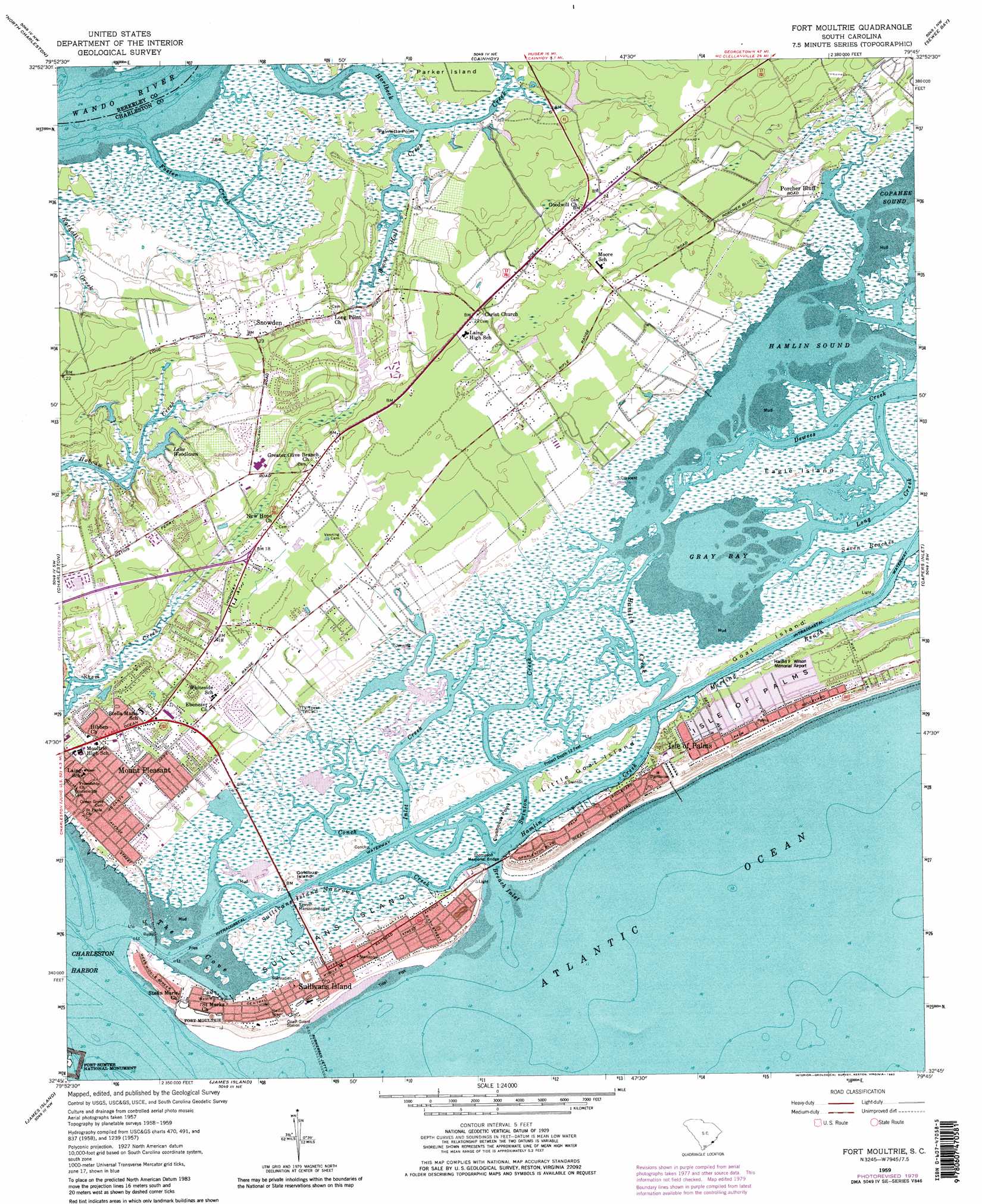
USGS Topo Quad 32079g7 - 1:24,000 scale
| Topo Map Name: | Fort Moultrie |
| USGS Topo Quad ID: | 32079g7 |
| Print Size: | ca. 21 1/4" wide x 27" high |
| Southeast Coordinates: | 32.75° N latitude / 79.75° W longitude |
| Map Center Coordinates: | 32.8125° N latitude / 79.8125° W longitude |
| U.S. State: | SC |
| Filename: | o32079g7.jpg |
| Download Map JPG Image: | Fort Moultrie topo map 1:24,000 scale |
| Map Type: | Topographic |
| Topo Series: | 7.5´ |
| Map Scale: | 1:24,000 |
| Source of Map Images: | United States Geological Survey (USGS) |
| Alternate Map Versions: |
Fort Moultrie SC 1943 Download PDF Buy paper map Fort Moultrie SC 1943 Download PDF Buy paper map Fort Moultrie SC 1959, updated 1960 Download PDF Buy paper map Fort Moultrie SC 1959, updated 1964 Download PDF Buy paper map Fort Moultrie SC 1959, updated 1973 Download PDF Buy paper map Fort Moultrie SC 1959, updated 1980 Download PDF Buy paper map Fort Moultrie SC 1959, updated 1980 Download PDF Buy paper map Fort Moultrie SC 2011 Download PDF Buy paper map Fort Moultrie SC 2014 Download PDF Buy paper map |
1:24,000 Topo Quads surrounding Fort Moultrie
Mount Holly |
Kittredge |
Huger |
Ocean Bay |
Awendaw |
Ladson |
North Charleston |
Cainhoy |
Sewee Bay |
Bull Island |
Johns Island |
Charleston |
Fort Moultrie |
Capers Inlet |
|
Legareville |
James Island |
|||
Kiawah Island |
> Back to 32079e1 at 1:100,000 scale
> Back to 32078a1 at 1:250,000 scale
> Back to U.S. Topo Maps home
Fort Moultrie topo map: Gazetteer
Fort Moultrie: Airports
Ravens Run Airport elevation 2m 6′Fort Moultrie: Bays
Breach Inlet elevation 2m 6′Gray Bay elevation 0m 0′
Hamlin Sound elevation 0m 0′
Jeanette Creek elevation 0m 0′
The Cove elevation 0m 0′
Fort Moultrie: Bridges
Ben M Sawyer Memorial Bridge elevation 0m 0′Thompson Memorial Bridge elevation 0m 0′
Fort Moultrie: Capes
Clubhouse Point elevation 1m 3′Old Womans Point elevation 9m 29′
Palmetto Point elevation 2m 6′
Fort Moultrie: Channels
Meeting Reach elevation 0m 0′Sullivans Island Narrows elevation 0m 0′
Fort Moultrie: Dams
South Carolina Noname 10033 D-1740 Dam elevation 3m 9′South Carolina Noname 10034 D-3045 Dam elevation 0m 0′
Fort Moultrie: Islands
Eagle Island elevation 0m 0′Goat Island elevation 1m 3′
Goldbug Island elevation 0m 0′
Island of Palms elevation 2m 6′
Little Goat Island elevation 0m 0′
Sullivans Island elevation 3m 9′
Fort Moultrie: Lakes
Lake Woodlawn elevation 0m 0′Fort Moultrie: Parks
Fort Sumter National Monument elevation 3m 9′Mount Pleasant Historic District elevation 12m 39′
Mount Pleasant Sports Complex elevation 5m 16′
United States Coast Guard Historic District elevation 2m 6′
Fort Moultrie: Populated Places
Avian Park elevation 2m 6′Brook Green Meadow elevation 7m 22′
Cassina Heights elevation 3m 9′
Creekside Park elevation 0m 0′
Forest Trail elevation 1m 3′
Fort Moultrie elevation 3m 9′
Harborgate elevation 3m 9′
Heritage elevation 2m 6′
Hickory Shadows elevation 3m 9′
Island of Palms elevation 0m 0′
Isle of Palms elevation 0m 0′
Moss Park elevation 4m 13′
Moultrie Heights elevation 1m 3′
Mount Pleasant elevation 3m 9′
Myrtle Acres elevation 2m 6′
Osceola Heights elevation 1m 3′
Osceola Oaks elevation 4m 13′
Palmetto Fort elevation 6m 19′
Parish Place elevation 8m 26′
Point Pleasant elevation 8m 26′
Porcher Bluff elevation 2m 6′
Seaside Farms Estates elevation 3m 9′
Shemwood elevation 8m 26′
Snowden elevation 6m 19′
Somerset Point elevation 3m 9′
Sullivans Island elevation 4m 13′
The Village elevation 2m 6′
Wando Estates elevation 1m 3′
Waterway Arms elevation 1m 3′
Fort Moultrie: Post Offices
Isle of Palms Post Office elevation 4m 13′Isle of Palms Post Office (historical) elevation 1m 3′
Sullivans Island Post Office elevation 4m 13′
Fort Moultrie: Reservoirs
Lake Wackedaw elevation 3m 9′Fort Moultrie: Streams
Boone Hall Creek elevation 0m 0′Conch Creek elevation 0m 0′
Foster Creek elevation 0m 0′
Hamlin Creek elevation 0m 0′
Inlet Creek elevation 0m 0′
Long Creek elevation 0m 0′
Morgan Creek elevation 0m 0′
Swinton Creek elevation 0m 0′
Fort Moultrie digital topo map on disk
Buy this Fort Moultrie topo map showing relief, roads, GPS coordinates and other geographical features, as a high-resolution digital map file on DVD:
South Carolina, Western North Carolina & Northeastern Georgia
Buy digital topo maps: South Carolina, Western North Carolina & Northeastern Georgia