North Charleston Topo Map South Carolina
To zoom in, hover over the map of North Charleston
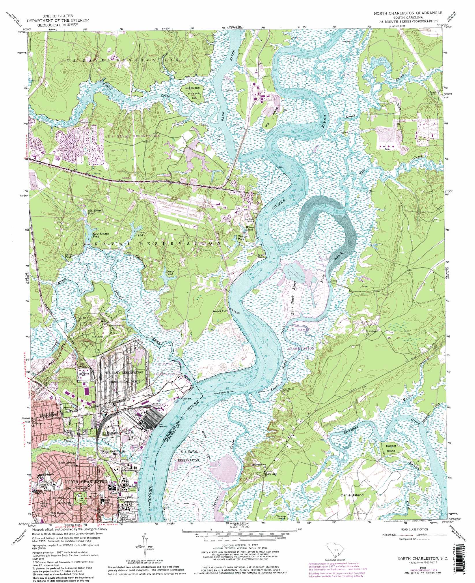
USGS Topo Quad 32079h8 - 1:24,000 scale
| Topo Map Name: | North Charleston |
| USGS Topo Quad ID: | 32079h8 |
| Print Size: | ca. 21 1/4" wide x 27" high |
| Southeast Coordinates: | 32.875° N latitude / 79.875° W longitude |
| Map Center Coordinates: | 32.9375° N latitude / 79.9375° W longitude |
| U.S. State: | SC |
| Filename: | o32079h8.jpg |
| Download Map JPG Image: | North Charleston topo map 1:24,000 scale |
| Map Type: | Topographic |
| Topo Series: | 7.5´ |
| Map Scale: | 1:24,000 |
| Source of Map Images: | United States Geological Survey (USGS) |
| Alternate Map Versions: |
Melgrove SC 1940 Download PDF Buy paper map North Charleston SC 1958, updated 1959 Download PDF Buy paper map North Charleston SC 1958, updated 1966 Download PDF Buy paper map North Charleston SC 1958, updated 1973 Download PDF Buy paper map North Charleston SC 1958, updated 1980 Download PDF Buy paper map North Charleston SC 1998, updated 1999 Download PDF Buy paper map North Charleston SC 2011 Download PDF Buy paper map North Charleston SC 2014 Download PDF Buy paper map |
1:24,000 Topo Quads surrounding North Charleston
Summerville Nw |
Moncks Corner |
Cordesville |
Bethera |
Shulerville |
Summerville |
Mount Holly |
Kittredge |
Huger |
Ocean Bay |
Stallsville |
Ladson |
North Charleston |
Cainhoy |
Sewee Bay |
Ravenel |
Johns Island |
Charleston |
Fort Moultrie |
Capers Inlet |
Wadmalaw Island |
Legareville |
James Island |
> Back to 32079e1 at 1:100,000 scale
> Back to 32078a1 at 1:250,000 scale
> Back to U.S. Topo Maps home
North Charleston topo map: Gazetteer
North Charleston: Capes
Snow Point elevation 0m 0′Woods Point elevation 0m 0′
North Charleston: Channels
Back Slack Reach elevation 6m 19′Slack Reach elevation 0m 0′
North Charleston: Dams
Army Depot Pond Dam D-3475 elevation 5m 16′North Charleston: Guts
Yellow House Creek elevation 0m 0′North Charleston: Islands
Big Island elevation 4m 13′Big Island elevation 5m 16′
Rhodens Island elevation 1m 3′
North Charleston: Parks
Bentley Park elevation 14m 45′Bushy Park elevation 9m 29′
Danny Jones Park elevation 8m 26′
Liberty Hill Park elevation 9m 29′
Murray Park elevation 12m 39′
Park Circle elevation 11m 36′
Swamp Park elevation 2m 6′
North Charleston: Populated Places
Charleston Farms elevation 12m 39′Deweys Hill elevation 3m 9′
Dominion Hills elevation 8m 26′
Gehlkin (historical) elevation 12m 39′
Gold Cup Springs elevation 10m 32′
John C Calhoun Homes elevation 8m 26′
Lakeview elevation 10m 32′
Melgrove (historical) elevation 5m 16′
Menriv Park elevation 10m 32′
Red Bank Landing elevation 0m 0′
Yellow House (historical) elevation 11m 36′
Yellow House Landing elevation 2m 6′
North Charleston: Post Offices
East Montague Post Office elevation 10m 32′US Naval Weapons Station Post Office elevation 6m 19′
North Charleston: Reservoirs
Brown Pond elevation 2m 6′Dutes Pond elevation 1m 3′
Georgie Pond elevation 4m 13′
Logan Pond elevation 1m 3′
New Tenant Pond elevation 0m 0′
Old Tenant Pond elevation 2m 6′
Wilson Pond elevation 4m 13′
North Charleston: Springs
Silver Cup Spring elevation 9m 29′North Charleston: Streams
Back River elevation 0m 0′Broad Creek elevation 9m 29′
Cowbell Branch elevation 0m 0′
Filbin Creek elevation 0m 0′
Flagg Creek elevation 0m 0′
Foster Creek elevation 0m 0′
Goose Creek elevation 0m 0′
Grove Creek elevation 1m 3′
Hopewell Creek elevation 0m 0′
Lynan Creek elevation 0m 0′
Martin Creek elevation -4m -14′
Nowell Creek elevation 0m 0′
Old Goose Creek elevation 2m 6′
North Charleston digital topo map on disk
Buy this North Charleston topo map showing relief, roads, GPS coordinates and other geographical features, as a high-resolution digital map file on DVD:
South Carolina, Western North Carolina & Northeastern Georgia
Buy digital topo maps: South Carolina, Western North Carolina & Northeastern Georgia