Parris Island Topo Map South Carolina
To zoom in, hover over the map of Parris Island
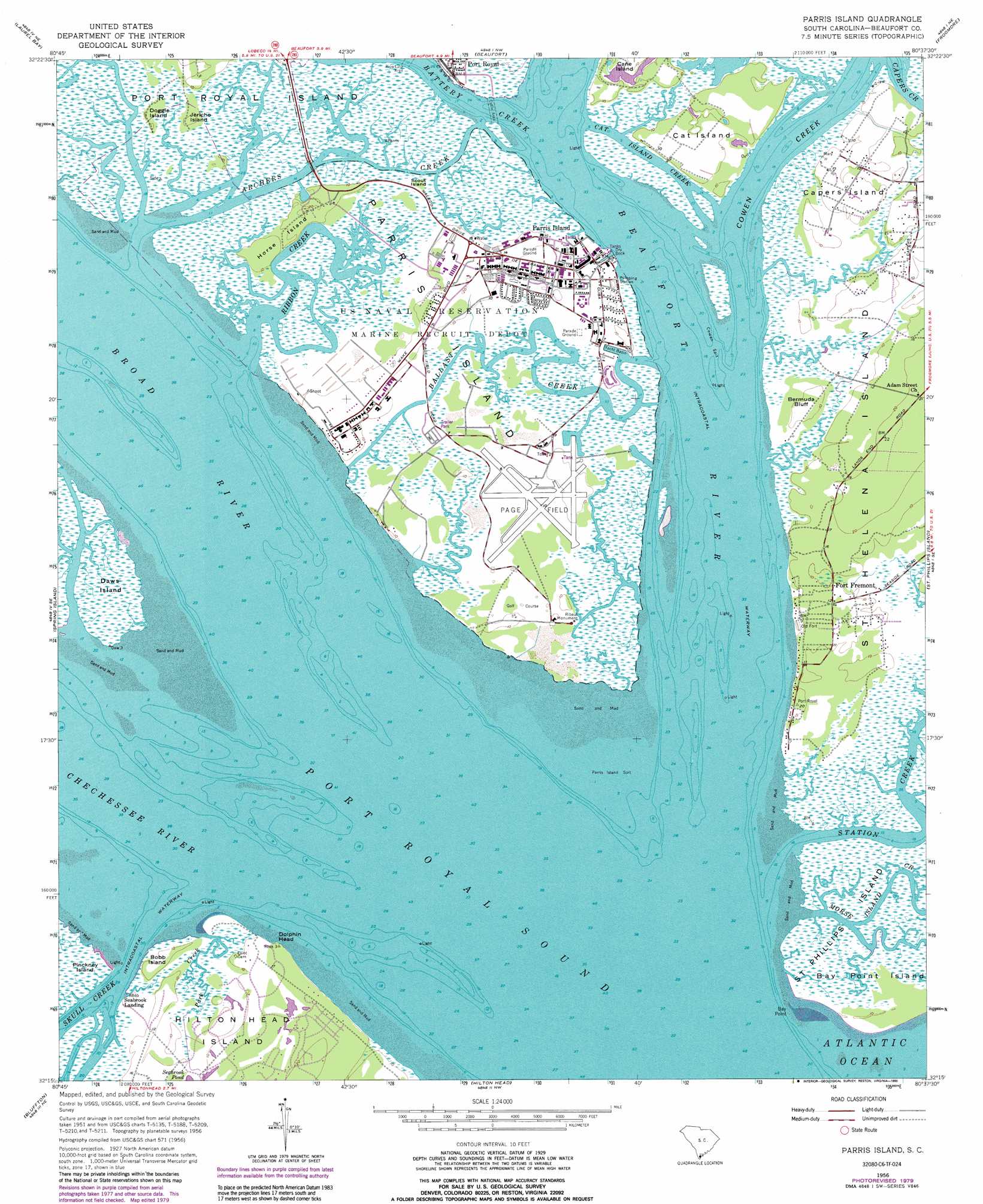
USGS Topo Quad 32080c6 - 1:24,000 scale
| Topo Map Name: | Parris Island |
| USGS Topo Quad ID: | 32080c6 |
| Print Size: | ca. 21 1/4" wide x 27" high |
| Southeast Coordinates: | 32.25° N latitude / 80.625° W longitude |
| Map Center Coordinates: | 32.3125° N latitude / 80.6875° W longitude |
| U.S. State: | SC |
| Filename: | o32080c6.jpg |
| Download Map JPG Image: | Parris Island topo map 1:24,000 scale |
| Map Type: | Topographic |
| Topo Series: | 7.5´ |
| Map Scale: | 1:24,000 |
| Source of Map Images: | United States Geological Survey (USGS) |
| Alternate Map Versions: |
Parris Island SC 1956, updated 1957 Download PDF Buy paper map Parris Island SC 1956, updated 1970 Download PDF Buy paper map Parris Island SC 1956, updated 1979 Download PDF Buy paper map Parris Island SC 1956, updated 1990 Download PDF Buy paper map Parris Island SC 1956, updated 1990 Download PDF Buy paper map Parris Island SC 2011 Download PDF Buy paper map Parris Island SC 2014 Download PDF Buy paper map |
1:24,000 Topo Quads surrounding Parris Island
Coosawhatchie |
Sheldon |
Dale |
Wiggins |
Bennetts Point |
Ridgeland |
Laurel Bay |
Beaufort |
Frogmore |
Saint Helena Sound |
Jasper |
Spring Island |
Parris Island |
Saint Phillips Island |
Fripps Inlet |
Pritchardville |
Bluffton |
Hilton Head |
||
Fort Pulaski |
Tybee Island North |
> Back to 32080a1 at 1:100,000 scale
> Back to 32080a1 at 1:250,000 scale
> Back to U.S. Topo Maps home
Parris Island topo map: Gazetteer
Parris Island: Bars
Cowen Spit elevation 0m 0′Middle Shoal elevation 0m 0′
Parris Island Spit elevation 0m 0′
Parris Island: Bays
Port Royal Sound elevation 0m 0′Parris Island: Capes
Bay Point elevation 0m 0′Dolphin Head elevation 2m 6′
Parris Island: Channels
Archers Creek elevation 0m 0′Cat Island Creek elevation 2m 6′
Cat Island Reach elevation 0m 0′
Cowen Reach elevation 0m 0′
Fort Fremont Reach elevation 0m 0′
Port Royal Reach elevation 0m 0′
Parris Island: Cliffs
Bermuda Bluff elevation 3m 9′Parris Island: Guts
Ballast Creek elevation 3m 9′Capers Creek elevation 0m 0′
Parris Island: Islands
Bay Point Island elevation 2m 6′Bobb Island elevation 2m 6′
Cane Island elevation 2m 6′
Capers Island elevation 3m 9′
Cat Island elevation 3m 9′
Doggie Island elevation 3m 9′
Horse Island elevation 4m 13′
Jericho Island elevation 3m 9′
Parris Island elevation 2m 6′
Scout Island elevation 2m 6′
Parris Island: Lakes
Seabrook Pond elevation 3m 9′Parris Island: Parks
Ribaut Monument elevation 2m 6′Parris Island: Populated Places
Fort Fremont elevation 3m 9′Hilton Head Plantation elevation 6m 19′
Lands End elevation 1m 3′
Santa Elena (historical) elevation 2m 6′
Seabrook Landing elevation 2m 6′
Parris Island: Post Offices
Parris Island Post Office elevation 3m 9′Parris Island: Streams
Battery Creek elevation 0m 0′Beaufort River elevation 0m 0′
Broad River elevation 0m 0′
Chechessee River elevation 0m 0′
Cowen Creek elevation 0m 0′
Means Creek elevation 0m 0′
Park Creek elevation 0m 0′
Ribbon Creek elevation 0m 0′
Whale Branch elevation 0m 0′
Parris Island digital topo map on disk
Buy this Parris Island topo map showing relief, roads, GPS coordinates and other geographical features, as a high-resolution digital map file on DVD:
South Carolina, Western North Carolina & Northeastern Georgia
Buy digital topo maps: South Carolina, Western North Carolina & Northeastern Georgia