Frogmore Topo Map South Carolina
To zoom in, hover over the map of Frogmore
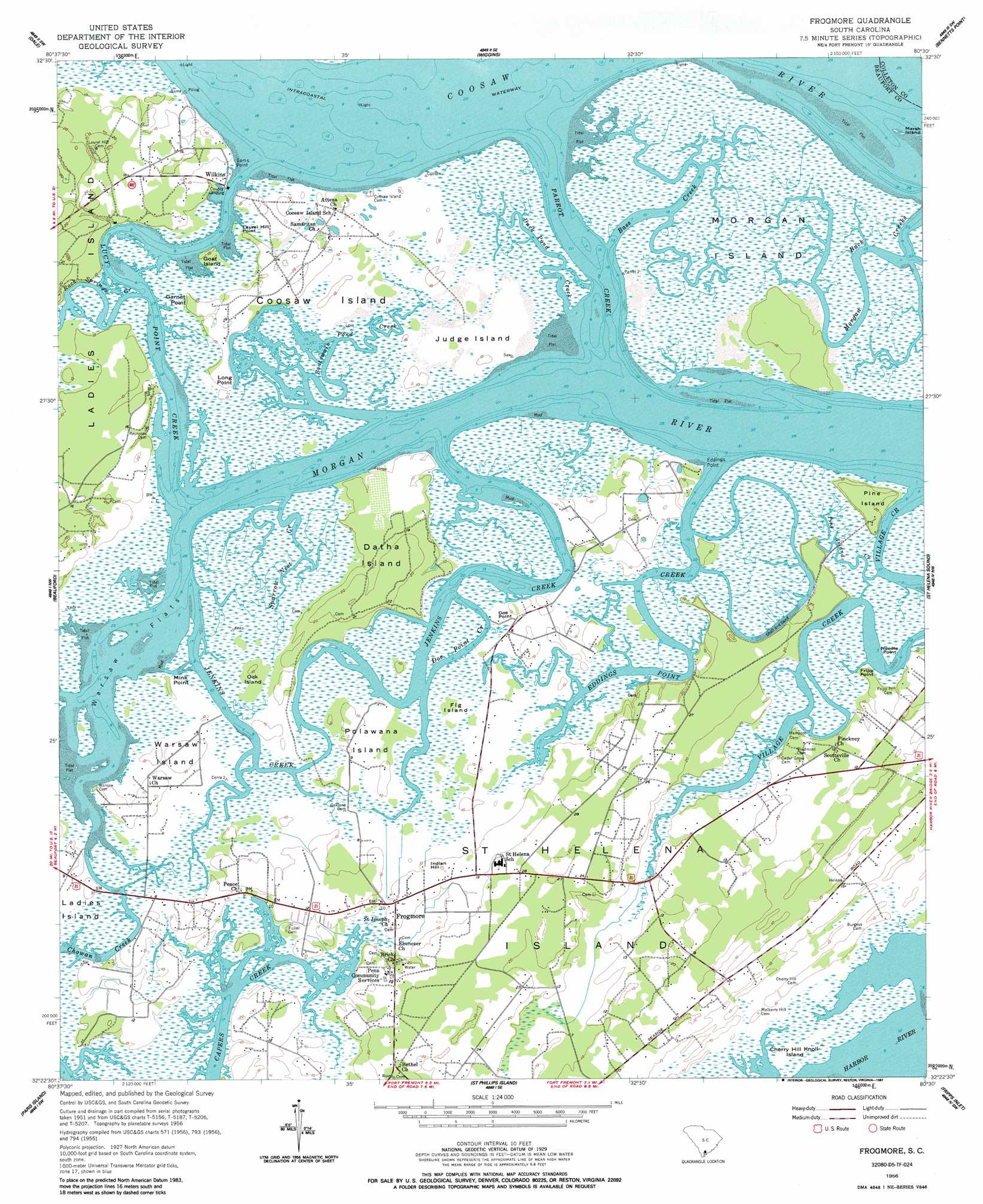
USGS Topo Quad 32080d5 - 1:24,000 scale
| Topo Map Name: | Frogmore |
| USGS Topo Quad ID: | 32080d5 |
| Print Size: | ca. 21 1/4" wide x 27" high |
| Southeast Coordinates: | 32.375° N latitude / 80.5° W longitude |
| Map Center Coordinates: | 32.4375° N latitude / 80.5625° W longitude |
| U.S. State: | SC |
| Filename: | o32080d5.jpg |
| Download Map JPG Image: | Frogmore topo map 1:24,000 scale |
| Map Type: | Topographic |
| Topo Series: | 7.5´ |
| Map Scale: | 1:24,000 |
| Source of Map Images: | United States Geological Survey (USGS) |
| Alternate Map Versions: |
Frogmore SC 1956, updated 1957 Download PDF Buy paper map Frogmore SC 1956, updated 1987 Download PDF Buy paper map Frogmore SC 1956, updated 1987 Download PDF Buy paper map Frogmore SC 2011 Download PDF Buy paper map Frogmore SC 2014 Download PDF Buy paper map |
1:24,000 Topo Quads surrounding Frogmore
Yemassee |
Whitehall |
Green Pond |
Fenwick |
Adams Run |
Sheldon |
Dale |
Wiggins |
Bennetts Point |
Edisto Island |
Laurel Bay |
Beaufort |
Frogmore |
Saint Helena Sound |
Edisto Beach |
Spring Island |
Parris Island |
Saint Phillips Island |
Fripps Inlet |
|
Bluffton |
Hilton Head |
> Back to 32080a1 at 1:100,000 scale
> Back to 32080a1 at 1:250,000 scale
> Back to U.S. Topo Maps home
Frogmore topo map: Gazetteer
Frogmore: Airports
Laurel Hill Plantation Airport elevation 5m 16′Marsh Point Airport elevation 3m 9′
Frogmore: Capes
Big Dataw Point elevation 0m 0′Doe Point elevation 3m 9′
Edding Point elevation 2m 6′
Fripp Point elevation 3m 9′
Garnet Point elevation 3m 9′
Laurel Hill Point elevation 3m 9′
Long Point elevation 3m 9′
Mink Point elevation 3m 9′
Needle Point elevation 3m 9′
Sams Point elevation 3m 9′
Frogmore: Channels
Doe Point Creek elevation 1m 3′Parrot Creek elevation 0m 0′
Frogmore: Flats
Warsaw Flats elevation 0m 0′Frogmore: Guts
Jenkins Creek elevation 0m 0′Morgan Back Creek elevation 3m 9′
Frogmore: Islands
Cherry Hill Knoll Island elevation 3m 9′Coosaw Island elevation 3m 9′
Datha Island elevation 6m 19′
Fig Island elevation 2m 6′
Goat Island elevation 3m 9′
Judge Island elevation 3m 9′
Marsh Island elevation 0m 0′
Morgan Island elevation 3m 9′
Oak Island elevation 3m 9′
Pine Island elevation 7m 22′
Polawana Island elevation 3m 9′
Saint Helena Island elevation 7m 22′
Warsaw Island elevation 3m 9′
Frogmore: Lakes
Spring Well Pond elevation 3m 9′Frogmore: Populated Places
Ashdale elevation 5m 16′Dataw Island elevation 7m 22′
Frogmore elevation 3m 9′
Wilkins elevation 3m 9′
Frogmore: Post Offices
Saint Helena Island Post Office elevation 3m 9′Frogmore: Reservoirs
Hill Field Lake elevation 3m 9′Frogmore: Streams
Bass Creek elevation 1m 3′Boatswain Pond Creek elevation 0m 0′
Duck Pond Creek elevation 0m 0′
Edding Creek elevation 0m 0′
Pine Island Creek elevation 2m 6′
Point Creek elevation 0m 0′
Rock Springs Creek elevation 1m 3′
Sparrow Nest Creek elevation 0m 0′
Village Creek elevation 0m 0′
Frogmore: Summits
Indian Hill elevation 5m 16′Frogmore digital topo map on disk
Buy this Frogmore topo map showing relief, roads, GPS coordinates and other geographical features, as a high-resolution digital map file on DVD:
South Carolina, Western North Carolina & Northeastern Georgia
Buy digital topo maps: South Carolina, Western North Carolina & Northeastern Georgia