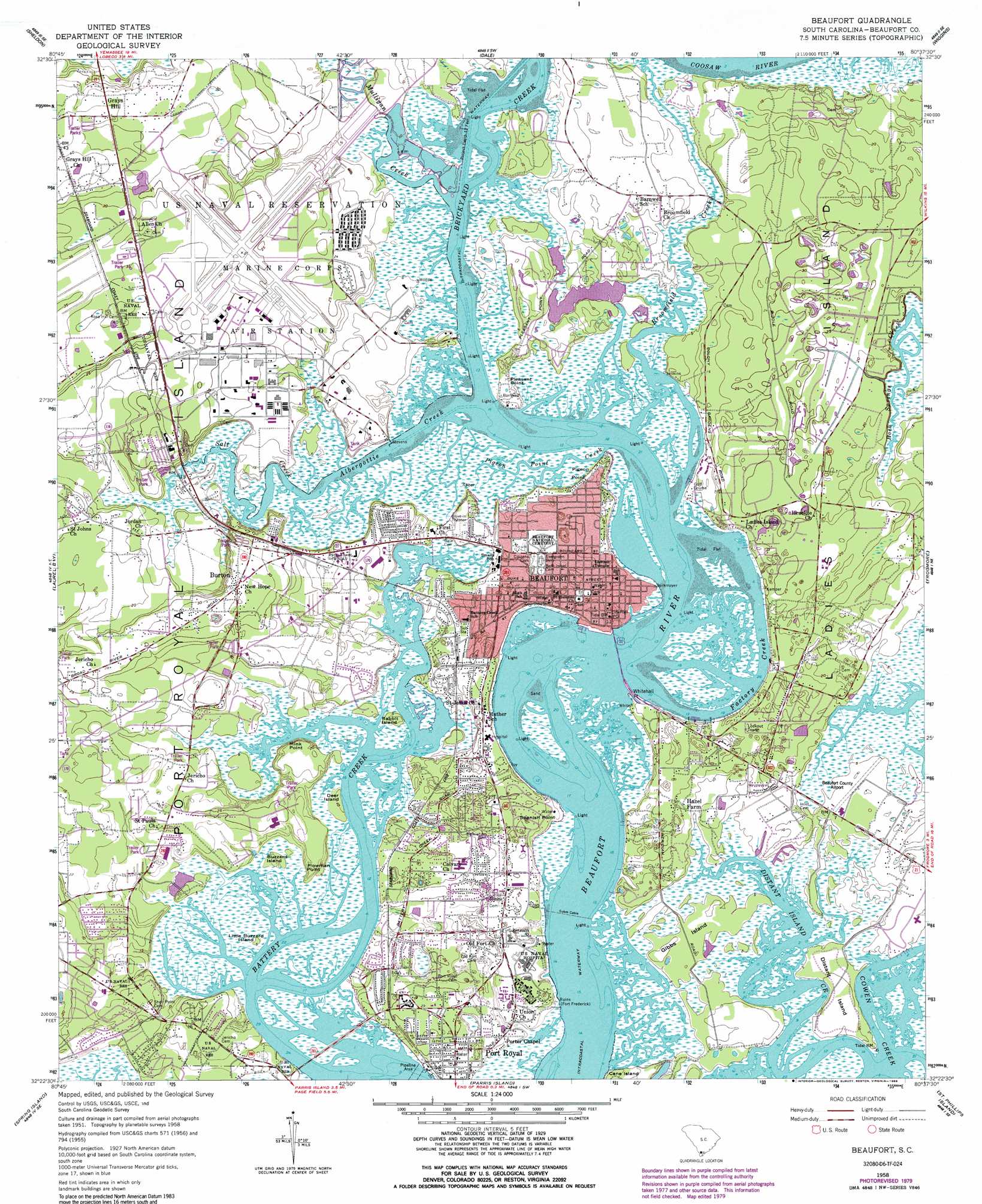
Beaufort Topo Map South Carolina
To zoom in, hover over the map of Beaufort
USGS Topo Quad 32080d6 - 1:24,000 scale
| Topo Map Name: | Beaufort |
| USGS Topo Quad ID: | 32080d6 |
| Print Size: | ca. 21 1/4" wide x 27" high |
| Southeast Coordinates: | 32.375° N latitude / 80.625° W longitude |
| Map Center Coordinates: | 32.4375° N latitude / 80.6875° W longitude |
| U.S. State: | SC |
| Filename: | o32080d6.jpg |
| Download Map JPG Image: | Beaufort topo map 1:24,000 scale |
| Map Type: | Topographic |
| Topo Series: | 7.5´ |
| Map Scale: | 1:24,000 |
| Source of Map Images: | United States Geological Survey (USGS) |
| Alternate Map Versions: |
Beaufort SC 1958, updated 1960 Download PDF Buy paper map Beaufort SC 1958, updated 1974 Download PDF Buy paper map Beaufort SC 1958, updated 1979 Download PDF Buy paper map Beaufort SC 1958, updated 1989 Download PDF Buy paper map Beaufort SC 1958, updated 1989 Download PDF Buy paper map Beaufort SC 1998, updated 1999 Download PDF Buy paper map Beaufort SC 2011 Download PDF Buy paper map Beaufort SC 2014 Download PDF Buy paper map |
1:24,000 Topo Quads surrounding Beaufort
Mcphersonville |
Yemassee |
Whitehall |
Green Pond |
Fenwick |
Coosawhatchie |
Sheldon |
Dale |
Wiggins |
Bennetts Point |
Ridgeland |
Laurel Bay |
Beaufort |
Frogmore |
Saint Helena Sound |
Jasper |
Spring Island |
Parris Island |
Saint Phillips Island |
Fripps Inlet |
Pritchardville |
Bluffton |
Hilton Head |
> Back to 32080a1 at 1:100,000 scale
> Back to 32080a1 at 1:250,000 scale
> Back to U.S. Topo Maps home
Beaufort topo map: Gazetteer
Beaufort: Airports
Beaufort County Airport elevation 3m 9′Beaufort County Memorial Hospital Heliport elevation 6m 19′
Beaufort Marine Corps Air Station elevation 8m 26′
Beaufort: Beaches
Burckmyers Beach elevation 1m 3′Burkmeyer Beach elevation 3m 9′
Beaufort: Bridges
McTeer Memorial Bridge elevation 0m 0′Saltwater Bridge elevation 2m 6′
Beaufort: Capes
Mink Point elevation 7m 22′Pigeon Point elevation 3m 9′
Pleasant Point elevation 2m 6′
Plowman Point elevation 4m 13′
Spanish Point elevation 5m 16′
Whitehall Point elevation 1m 3′
Beaufort: Channels
Factory Creek elevation 0m 0′Beaufort: Cliffs
Barnwell Bluff elevation 3m 9′Beaufort: Dams
South Carolina Noname 07005 D-2933 Dam elevation 2m 6′Beaufort: Islands
Buzzard Island elevation 3m 9′Deer Island elevation 2m 6′
Distant Island elevation 3m 9′
Gibbs Island elevation 2m 6′
Ladys Island elevation 5m 16′
Little Buzzard Island elevation 1m 3′
Port Royal Island elevation 6m 19′
Rabbit Island elevation 3m 9′
Beaufort: Parks
Arthur Horne Nature Park elevation 2m 6′Beaufort Historic District elevation 3m 9′
Calhoun Thomas Memorial Gardens elevation 5m 16′
Waterfront Park elevation 2m 6′
Beaufort: Populated Places
Academy Estates elevation 4m 13′Attaway elevation 6m 19′
Battery Marina Village elevation 4m 13′
Beaufort elevation 2m 6′
Blue Heron Bluff elevation 6m 19′
Bluff Farm elevation 8m 26′
Bon Aire elevation 5m 16′
Burton elevation 10m 32′
Cherry Hill Estates elevation 5m 16′
Colonial Heights elevation 6m 19′
Colony Gardens Estates elevation 3m 9′
Country Club Bluff elevation 2m 6′
Daniels elevation 6m 19′
Dowlingwood elevation 6m 19′
Forest Fields elevation 4m 13′
Gay Oaks elevation 5m 16′
Grays Hill elevation 12m 39′
Green Pond elevation 2m 6′
Hazel Farm elevation 4m 13′
James Byrnes Estates elevation 7m 22′
Lucy Creek elevation 6m 19′
Magnolia Bluff elevation 8m 26′
Mariners Watch elevation 9m 29′
Mark Island elevation 3m 9′
Marsh Harbor elevation 3m 9′
Marsh Hawk elevation 7m 22′
Mink Point Plantation elevation 6m 19′
Morgan River Estates elevation 3m 9′
Oakwood Park elevation 4m 13′
Orange Grove elevation 3m 9′
Palmetto Estates elevation 2m 6′
Partridge Woods elevation 2m 6′
Peace Haven elevation 5m 16′
Pepper Hill elevation 7m 22′
Pine Hill Acres elevation 8m 26′
Pleasant Point elevation 4m 13′
Polk Village elevation 5m 16′
Port Royal elevation 7m 22′
Port Royal Landing elevation 6m 19′
Quail Run elevation 7m 22′
Red Bluff Estates elevation 2m 6′
Red Oak elevation 5m 16′
Rivers Edge elevation 4m 13′
Riverwind elevation 6m 19′
Roseida elevation 9m 29′
Royal Pines Country Club Estates elevation 6m 19′
Salem Plantation elevation 5m 16′
Salt Creek elevation 3m 9′
Sangster Village elevation 5m 16′
Shell Point elevation 5m 16′
Shell Point park elevation 4m 13′
Sherwood Forest elevation 4m 13′
Springfield elevation 8m 26′
Tanglewood elevation 5m 16′
Walling Grove elevation 2m 6′
Walnut Hill elevation 7m 22′
Walsh elevation 6m 19′
Waterford Place elevation 5m 16′
Yacht Club Estates elevation 4m 13′
Beaufort: Post Offices
Beaufort Post Office elevation 2m 6′Burton Branch Post Office elevation 4m 13′
Port Royal Post Office elevation 4m 13′
Beaufort: Streams
Albergottie Creek elevation 0m 0′Brickyard Creek elevation 0m 0′
Broomfield Creek elevation 0m 0′
Distant Island Creek elevation 0m 0′
Mulligan Creek elevation 0m 0′
Pigeon Point Creek elevation 0m 0′
Salt Creek elevation 0m 0′
Beaufort digital topo map on disk
Buy this Beaufort topo map showing relief, roads, GPS coordinates and other geographical features, as a high-resolution digital map file on DVD:
South Carolina, Western North Carolina & Northeastern Georgia
Buy digital topo maps: South Carolina, Western North Carolina & Northeastern Georgia