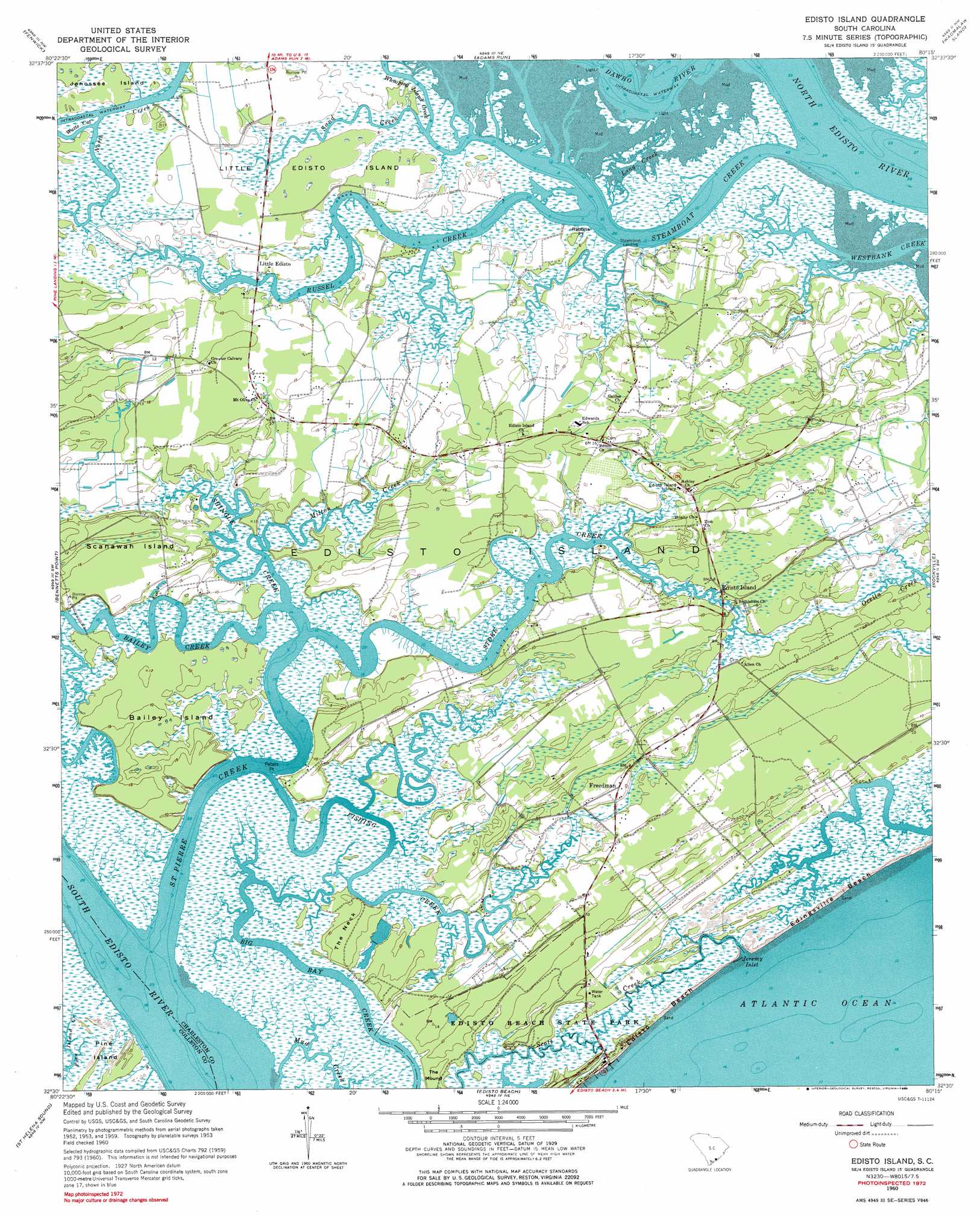
Edisto Island Topo Map South Carolina
To zoom in, hover over the map of Edisto Island
USGS Topo Quad 32080e3 - 1:24,000 scale
| Topo Map Name: | Edisto Island |
| USGS Topo Quad ID: | 32080e3 |
| Print Size: | ca. 21 1/4" wide x 27" high |
| Southeast Coordinates: | 32.5° N latitude / 80.25° W longitude |
| Map Center Coordinates: | 32.5625° N latitude / 80.3125° W longitude |
| U.S. State: | SC |
| Filename: | o32080e3.jpg |
| Download Map JPG Image: | Edisto Island topo map 1:24,000 scale |
| Map Type: | Topographic |
| Topo Series: | 7.5´ |
| Map Scale: | 1:24,000 |
| Source of Map Images: | United States Geological Survey (USGS) |
| Alternate Map Versions: |
Edisto Island SC 1960, updated 1965 Download PDF Buy paper map Edisto Island SC 1960, updated 1975 Download PDF Buy paper map Edisto Island SC 1960, updated 1984 Download PDF Buy paper map Edisto Island SC 2011 Download PDF Buy paper map Edisto Island SC 2014 Download PDF Buy paper map |
1:24,000 Topo Quads surrounding Edisto Island
Neyles |
Jacksonboro |
Osborn |
Ravenel |
Johns Island |
Green Pond |
Fenwick |
Adams Run |
Wadmalaw Island |
Legareville |
Wiggins |
Bennetts Point |
Edisto Island |
Rockville |
Kiawah Island |
Frogmore |
Saint Helena Sound |
Edisto Beach |
||
Saint Phillips Island |
Fripps Inlet |
> Back to 32080e1 at 1:100,000 scale
> Back to 32080a1 at 1:250,000 scale
> Back to U.S. Topo Maps home
Edisto Island topo map: Gazetteer
Edisto Island: Beaches
Edingsville Beach elevation 2m 6′Edisto Island: Capes
Peters Point elevation 0m 0′Rabbits Point elevation 4m 13′
The Neck elevation 2m 6′
Edisto Island: Guts
Jeremy Inlet elevation 0m 0′Edisto Island: Islands
Bailey Island elevation 3m 9′Edings Island elevation 1m 3′
Edisto Island elevation 7m 22′
Little Edisto Island elevation 2m 6′
Scanawah Island elevation 5m 16′
Edisto Island: Parks
Edisto Beach State Park elevation 1m 3′Edisto Island: Populated Places
Edisto Island elevation 2m 6′Freedman elevation 5m 16′
Little Edisto elevation 2m 6′
Steamboat Landing elevation 2m 6′
Edisto Island: Streams
Bailey Creek elevation 1m 3′Fishing Creek elevation 0m 0′
Long Creek elevation 0m 0′
Milton Creek elevation 0m 0′
Mud Creek elevation 0m 0′
Russel Creek elevation 0m 0′
Saint Pierre Creek elevation 0m 0′
Sand Creek elevation 0m 0′
Scott Creek elevation 0m 0′
Shingle Creek elevation 0m 0′
Steamboat Creek elevation 0m 0′
Store Creek elevation 0m 0′
Whooping Island Creek elevation 1m 3′
Edisto Island: Summits
The Mound elevation 0m 0′Edisto Island digital topo map on disk
Buy this Edisto Island topo map showing relief, roads, GPS coordinates and other geographical features, as a high-resolution digital map file on DVD:
South Carolina, Western North Carolina & Northeastern Georgia
Buy digital topo maps: South Carolina, Western North Carolina & Northeastern Georgia