Coosawhatchie Topo Map South Carolina
To zoom in, hover over the map of Coosawhatchie
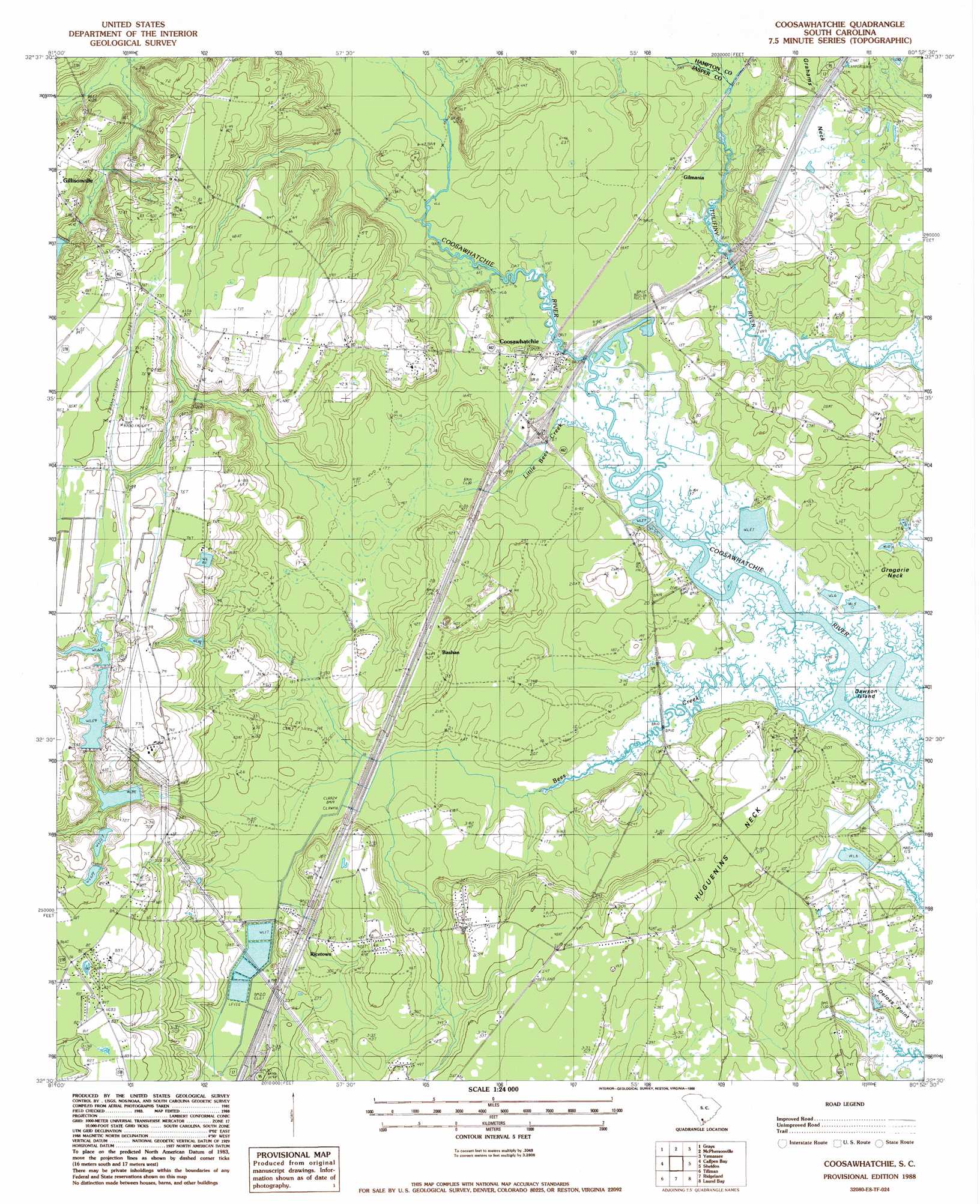
USGS Topo Quad 32080e8 - 1:24,000 scale
| Topo Map Name: | Coosawhatchie |
| USGS Topo Quad ID: | 32080e8 |
| Print Size: | ca. 21 1/4" wide x 27" high |
| Southeast Coordinates: | 32.5° N latitude / 80.875° W longitude |
| Map Center Coordinates: | 32.5625° N latitude / 80.9375° W longitude |
| U.S. State: | SC |
| Filename: | o32080e8.jpg |
| Download Map JPG Image: | Coosawhatchie topo map 1:24,000 scale |
| Map Type: | Topographic |
| Topo Series: | 7.5´ |
| Map Scale: | 1:24,000 |
| Source of Map Images: | United States Geological Survey (USGS) |
| Alternate Map Versions: |
Coosawhatchie SC 1988, updated 1988 Download PDF Buy paper map Coosawhatchie SC 2011 Download PDF Buy paper map Coosawhatchie SC 2014 Download PDF Buy paper map |
1:24,000 Topo Quads surrounding Coosawhatchie
Gifford |
Hampton |
Cummings |
Black Creek |
Hendersonville |
Furman |
Grays |
Mcphersonville |
Yemassee |
Whitehall |
Pineland |
Calfpen Bay |
Coosawhatchie |
Sheldon |
Dale |
Hardeeville Nw |
Tillman |
Ridgeland |
Laurel Bay |
Beaufort |
Rincon |
Hardeeville |
Jasper |
Spring Island |
Parris Island |
> Back to 32080e1 at 1:100,000 scale
> Back to 32080a1 at 1:250,000 scale
> Back to U.S. Topo Maps home
Coosawhatchie topo map: Gazetteer
Coosawhatchie: Capes
Deloss Point elevation 5m 16′Grahams Neck elevation 13m 42′
Gregorie Neck elevation 4m 13′
Huguenins Neck elevation 10m 32′
Coosawhatchie: Crossings
Interchange 22 elevation 10m 32′Interchange 28 elevation 6m 19′
Coosawhatchie: Dams
South Carolina Noname 27006 D-2581 Dam elevation 23m 75′Coosawhatchie: Islands
Dawson Island elevation 1m 3′Coosawhatchie: Populated Places
Bashan elevation 12m 39′Coosawhatchie elevation 3m 9′
Gilmania elevation 6m 19′
Ricetown elevation 10m 32′
Coosawhatchie: Streams
Bees Creek elevation 1m 3′Captain Bill Creek elevation 5m 16′
Little Bees Creek elevation 2m 6′
Coosawhatchie digital topo map on disk
Buy this Coosawhatchie topo map showing relief, roads, GPS coordinates and other geographical features, as a high-resolution digital map file on DVD:
South Carolina, Western North Carolina & Northeastern Georgia
Buy digital topo maps: South Carolina, Western North Carolina & Northeastern Georgia