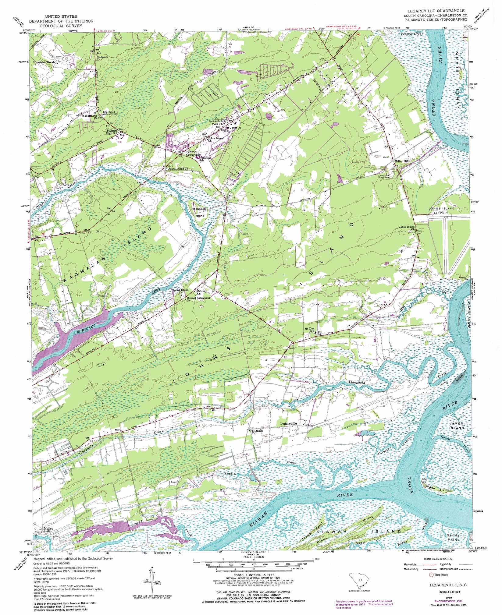
Legareville Topo Map South Carolina
To zoom in, hover over the map of Legareville
USGS Topo Quad 32080f1 - 1:24,000 scale
| Topo Map Name: | Legareville |
| USGS Topo Quad ID: | 32080f1 |
| Print Size: | ca. 21 1/4" wide x 27" high |
| Southeast Coordinates: | 32.625° N latitude / 80° W longitude |
| Map Center Coordinates: | 32.6875° N latitude / 80.0625° W longitude |
| U.S. State: | SC |
| Filename: | o32080f1.jpg |
| Download Map JPG Image: | Legareville topo map 1:24,000 scale |
| Map Type: | Topographic |
| Topo Series: | 7.5´ |
| Map Scale: | 1:24,000 |
| Source of Map Images: | United States Geological Survey (USGS) |
| Alternate Map Versions: |
Legareville SC 1943 Download PDF Buy paper map Legareville SC 1943 Download PDF Buy paper map Legareville SC 1959, updated 1960 Download PDF Buy paper map Legareville SC 1959, updated 1972 Download PDF Buy paper map Legareville SC 1959, updated 1988 Download PDF Buy paper map Legareville SC 2011 Download PDF Buy paper map Legareville SC 2014 Download PDF Buy paper map |
1:24,000 Topo Quads surrounding Legareville
Clubhouse Crossroads |
Stallsville |
Ladson |
North Charleston |
Cainhoy |
Osborn |
Ravenel |
Johns Island |
Charleston |
Fort Moultrie |
Adams Run |
Wadmalaw Island |
Legareville |
James Island |
|
Edisto Island |
Rockville |
Kiawah Island |
||
Edisto Beach |
> Back to 32080e1 at 1:100,000 scale
> Back to 32080a1 at 1:250,000 scale
> Back to U.S. Topo Maps home
Legareville topo map: Gazetteer
Legareville: Airports
Charleston Executive Airport elevation 4m 13′W B Upshur Private Airport elevation 0m 0′
Legareville: Bridges
Bugby Bridge (historical) elevation 0m 0′Church Bridge elevation 2m 6′
Legareville: Capes
Thumb Point elevation 4m 13′Legareville: Islands
Hoopstick Island elevation 8m 26′Johns Island elevation 6m 19′
Snake Island elevation 2m 6′
Legareville: Parks
Gaud School Playground elevation 7m 22′Legareville: Populated Places
Cedar Springs elevation 7m 22′Fenwick Crossroads elevation 11m 36′
Fenwick Hills elevation 11m 36′
Humbert Woods elevation 8m 26′
Huskum Corner Cross Roads elevation 7m 22′
Legareville elevation 8m 26′
Miller Hill elevation 6m 19′
Point Park Estates elevation 5m 16′
Shoreline Farms elevation 6m 19′
Stafford Heights elevation 7m 22′
Legareville: Post Offices
Johns Island Post Office elevation 9m 29′Legareville: Streams
Abbapoola Creek elevation 0m 0′Alligator Creek elevation 3m 9′
Bass Creek elevation 0m 0′
Chaplin Creek elevation 0m 0′
Cinder Creek elevation 0m 0′
Green Creek elevation 0m 0′
Holland Island Creek elevation 0m 0′
Hut Creek elevation 0m 0′
Kiawah River elevation 0m 0′
Stono River elevation 0m 0′
Legareville: Swamps
Bloody Dick Swamp elevation 5m 16′Isinglass Swamp elevation 2m 6′
Legareville digital topo map on disk
Buy this Legareville topo map showing relief, roads, GPS coordinates and other geographical features, as a high-resolution digital map file on DVD:
South Carolina, Western North Carolina & Northeastern Georgia
Buy digital topo maps: South Carolina, Western North Carolina & Northeastern Georgia