Wadmalaw Island Topo Map South Carolina
To zoom in, hover over the map of Wadmalaw Island
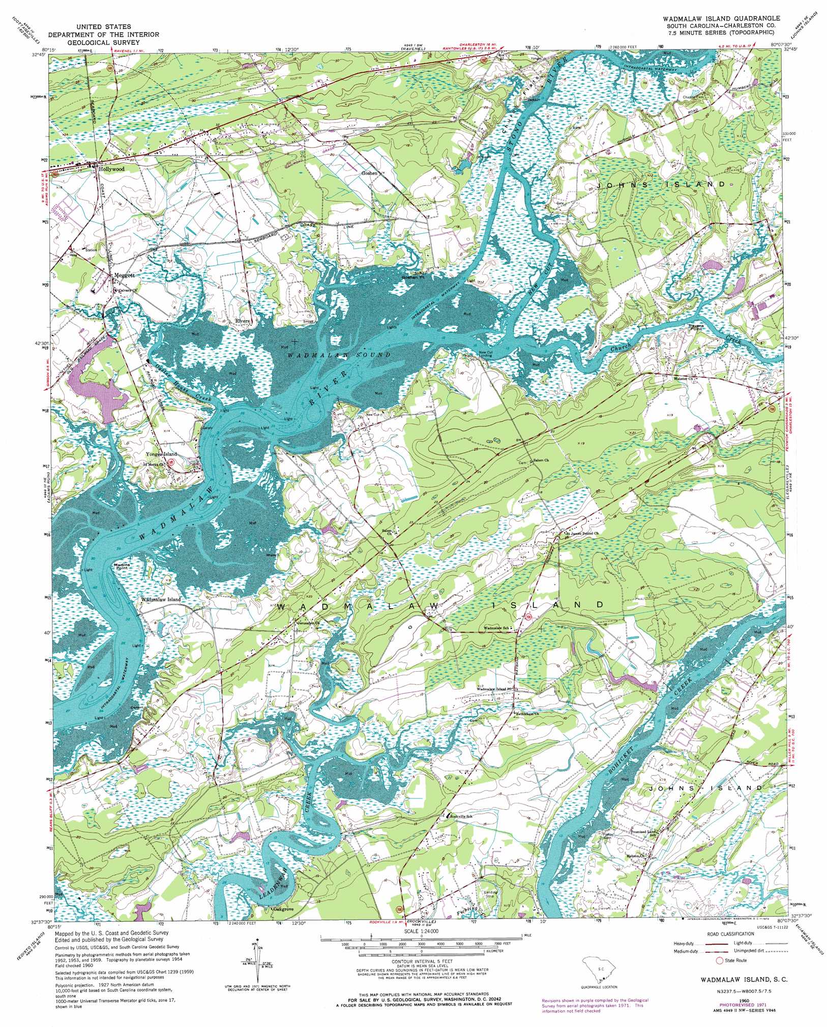
USGS Topo Quad 32080f2 - 1:24,000 scale
| Topo Map Name: | Wadmalaw Island |
| USGS Topo Quad ID: | 32080f2 |
| Print Size: | ca. 21 1/4" wide x 27" high |
| Southeast Coordinates: | 32.625° N latitude / 80.125° W longitude |
| Map Center Coordinates: | 32.6875° N latitude / 80.1875° W longitude |
| U.S. State: | SC |
| Filename: | o32080f2.jpg |
| Download Map JPG Image: | Wadmalaw Island topo map 1:24,000 scale |
| Map Type: | Topographic |
| Topo Series: | 7.5´ |
| Map Scale: | 1:24,000 |
| Source of Map Images: | United States Geological Survey (USGS) |
| Alternate Map Versions: |
Wadmalaw Island SC 1960, updated 1964 Download PDF Buy paper map Wadmalaw Island SC 1960, updated 1972 Download PDF Buy paper map Wadmalaw Island SC 2011 Download PDF Buy paper map Wadmalaw Island SC 2014 Download PDF Buy paper map |
1:24,000 Topo Quads surrounding Wadmalaw Island
Cottageville |
Clubhouse Crossroads |
Stallsville |
Ladson |
North Charleston |
Jacksonboro |
Osborn |
Ravenel |
Johns Island |
Charleston |
Fenwick |
Adams Run |
Wadmalaw Island |
Legareville |
James Island |
Bennetts Point |
Edisto Island |
Rockville |
Kiawah Island |
|
Saint Helena Sound |
Edisto Beach |
> Back to 32080e1 at 1:100,000 scale
> Back to 32080a1 at 1:250,000 scale
> Back to U.S. Topo Maps home
Wadmalaw Island topo map: Gazetteer
Wadmalaw Island: Airports
Yonges Island Airport elevation 8m 26′Wadmalaw Island: Bays
Wadmalaw Sound elevation 0m 0′Wadmalaw Island: Capes
Goshen Point elevation 2m 6′Martins Point elevation 6m 19′
Ravens Point elevation 7m 22′
Wadmalaw Island: Channels
New Cut elevation 0m 0′Wadmalaw Island: Cliffs
Church Flats Bluff elevation 2m 6′Wadmalaw Island: Flats
Church Flats elevation 1m 3′Wadmalaw Island: Islands
Wadmalaw Island elevation 12m 39′Yonges Island elevation 9m 29′
Wadmalaw Island: Populated Places
Clementia (historical) elevation 10m 32′Goshen elevation 10m 32′
Hollywood elevation 13m 42′
Meggett elevation 7m 22′
New Cut Landing elevation 9m 29′
Oakgrove elevation 8m 26′
Wadmalaw Island elevation 6m 19′
Yonges Island elevation 8m 26′
Wadmalaw Island: Post Offices
Hollywood Post Office elevation 12m 39′Wadmalaw Island Post Office elevation 10m 32′
Yonges Island Post Office elevation 5m 16′
Wadmalaw Island: Streams
Church Creek elevation 0m 0′Oyster House Creek elevation 0m 0′
Wadmalaw Island digital topo map on disk
Buy this Wadmalaw Island topo map showing relief, roads, GPS coordinates and other geographical features, as a high-resolution digital map file on DVD:
South Carolina, Western North Carolina & Northeastern Georgia
Buy digital topo maps: South Carolina, Western North Carolina & Northeastern Georgia