Stallsville Topo Map South Carolina
To zoom in, hover over the map of Stallsville
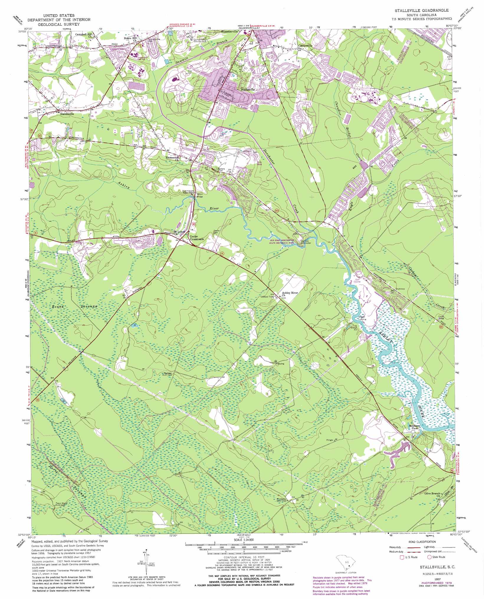
USGS Topo Quad 32080h2 - 1:24,000 scale
| Topo Map Name: | Stallsville |
| USGS Topo Quad ID: | 32080h2 |
| Print Size: | ca. 21 1/4" wide x 27" high |
| Southeast Coordinates: | 32.875° N latitude / 80.125° W longitude |
| Map Center Coordinates: | 32.9375° N latitude / 80.1875° W longitude |
| U.S. State: | SC |
| Filename: | o32080h2.jpg |
| Download Map JPG Image: | Stallsville topo map 1:24,000 scale |
| Map Type: | Topographic |
| Topo Series: | 7.5´ |
| Map Scale: | 1:24,000 |
| Source of Map Images: | United States Geological Survey (USGS) |
| Alternate Map Versions: |
Stallsville SC 1957, updated 1959 Download PDF Buy paper map Stallsville SC 1957, updated 1980 Download PDF Buy paper map Stallsville SC 2011 Download PDF Buy paper map Stallsville SC 2014 Download PDF Buy paper map |
1:24,000 Topo Quads surrounding Stallsville
Harleyville |
Pringletown |
Summerville Nw |
Moncks Corner |
Cordesville |
Maple Cane Swamp |
Ridgeville |
Summerville |
Mount Holly |
Kittredge |
Cottageville |
Clubhouse Crossroads |
Stallsville |
Ladson |
North Charleston |
Jacksonboro |
Osborn |
Ravenel |
Johns Island |
Charleston |
Fenwick |
Adams Run |
Wadmalaw Island |
Legareville |
James Island |
> Back to 32080e1 at 1:100,000 scale
> Back to 32080a1 at 1:250,000 scale
> Back to U.S. Topo Maps home
Stallsville topo map: Gazetteer
Stallsville: Bridges
Bacon Bridge elevation 5m 16′Stallsville: Dams
Lake Ashborough Dam D-2553 elevation 9m 29′South Carolina Noname 10010 Dam elevation 15m 49′
Stallsville: Parks
Mateeba Gardens elevation 11m 36′Middleton Gardens elevation 12m 39′
Old Fort Dorchester State Historical Park elevation 10m 32′
Stallsville: Populated Places
Ashborough elevation 13m 42′Ashborough East elevation 12m 39′
Ashley Forest elevation 16m 52′
Ashley Retreat elevation 9m 29′
Avenue of Oaks elevation 11m 36′
Barney Ridge elevation 22m 72′
Briarwood elevation 25m 82′
Calomet Valley elevation 19m 62′
Centerville elevation 24m 78′
Chandler Lakes elevation 18m 59′
Chandler Village elevation 15m 49′
Cooke Crossroads elevation 9m 29′
Country Club Estates elevation 23m 75′
Coventry Place elevation 12m 39′
Creekside elevation 11m 36′
Crestwood elevation 23m 75′
Crichton Parish elevation 10m 32′
Dorchester (historical) elevation 11m 36′
Dorchester Crossing elevation 12m 39′
Dorchester Estates elevation 22m 72′
Evergreen elevation 15m 49′
Fairlawn Terrace elevation 16m 52′
Farmdale elevation 24m 78′
Flowertown Village elevation 20m 65′
Greenhurst elevation 14m 45′
Greggs Landing elevation 0m 0′
Indian Springs elevation 19m 62′
Iron Gate elevation 16m 52′
Jamison Terrace elevation 19m 62′
Kings Grant elevation 10m 32′
Laurel Hill elevation 23m 75′
Marlin Estates elevation 21m 68′
Moss Point elevation 13m 42′
Newington Plantation elevation 22m 72′
Oakbrook elevation 9m 29′
Oakdale Estates elevation 20m 65′
Oakmont elevation 11m 36′
Old Fort Estates elevation 19m 62′
Plantation Ridge elevation 14m 45′
Quail Arbor elevation 21m 68′
Salisbury Acres elevation 26m 85′
Slandsville elevation 22m 72′
Southern Palms elevation 21m 68′
Sprucewood elevation 12m 39′
Stallsville elevation 26m 85′
Summerville Farms elevation 24m 78′
Summerville Place elevation 21m 68′
Summerwood elevation 9m 29′
Tranquil Acres elevation 11m 36′
Tranquil Estates elevation 13m 42′
Waters Edge elevation 1m 3′
West Oaks elevation 17m 55′
Westoe elevation 14m 45′
White Church Place elevation 14m 45′
Wood Oak Park elevation 23m 75′
Woodland Estates elevation 15m 49′
Woodlawn elevation 26m 85′
Stallsville: Reservoirs
Lake Ashborough elevation 9m 29′Stallsville: Streams
Chandler Bridge Creek elevation 9m 29′Coosaw Creek elevation 0m 0′
Dorchester Creek elevation 0m 0′
Eagle Creek elevation 0m 0′
Sawmill Branch elevation 14m 45′
Stallsville: Swamps
Round Savanna elevation 5m 16′Stallsville digital topo map on disk
Buy this Stallsville topo map showing relief, roads, GPS coordinates and other geographical features, as a high-resolution digital map file on DVD:
South Carolina, Western North Carolina & Northeastern Georgia
Buy digital topo maps: South Carolina, Western North Carolina & Northeastern Georgia