Cottageville Topo Map South Carolina
To zoom in, hover over the map of Cottageville
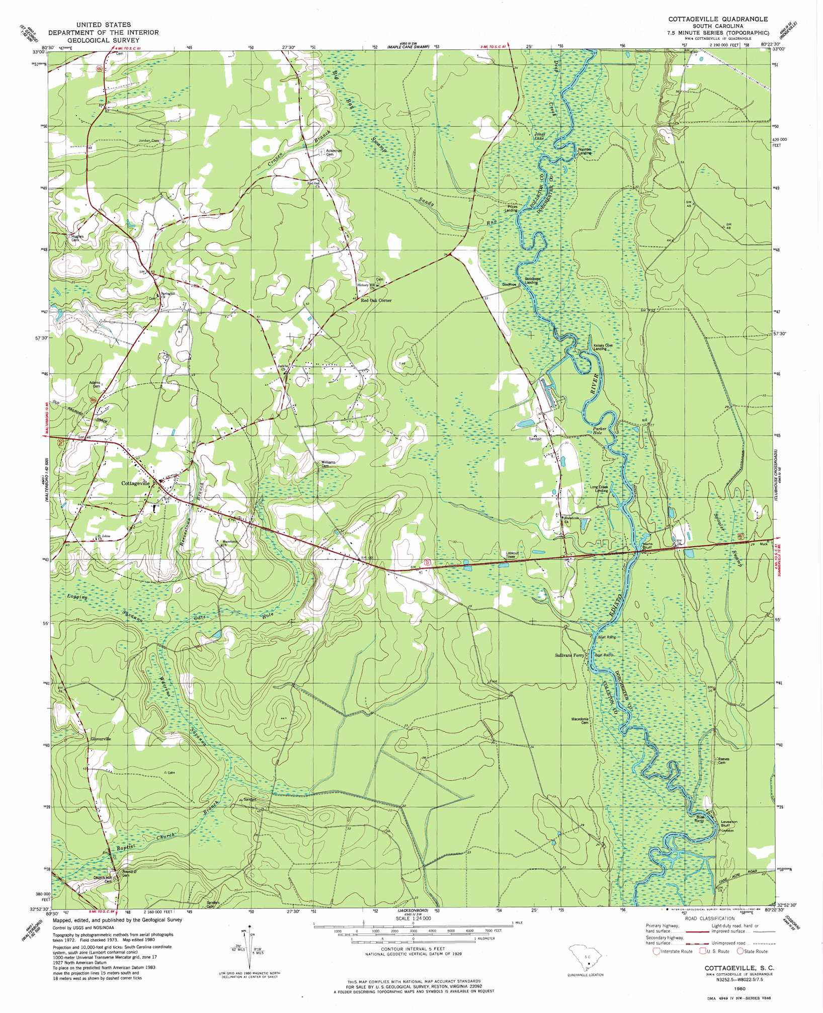
USGS Topo Quad 32080h4 - 1:24,000 scale
| Topo Map Name: | Cottageville |
| USGS Topo Quad ID: | 32080h4 |
| Print Size: | ca. 21 1/4" wide x 27" high |
| Southeast Coordinates: | 32.875° N latitude / 80.375° W longitude |
| Map Center Coordinates: | 32.9375° N latitude / 80.4375° W longitude |
| U.S. State: | SC |
| Filename: | o32080h4.jpg |
| Download Map JPG Image: | Cottageville topo map 1:24,000 scale |
| Map Type: | Topographic |
| Topo Series: | 7.5´ |
| Map Scale: | 1:24,000 |
| Source of Map Images: | United States Geological Survey (USGS) |
| Alternate Map Versions: |
Cottageville SC 1980, updated 1980 Download PDF Buy paper map Cottageville SC 1980, updated 1984 Download PDF Buy paper map Cottageville SC 2011 Download PDF Buy paper map Cottageville SC 2014 Download PDF Buy paper map |
1:24,000 Topo Quads surrounding Cottageville
Reevesville |
Saint George |
Harleyville |
Pringletown |
Summerville Nw |
Saint George Sw |
Canadys |
Maple Cane Swamp |
Ridgeville |
Summerville |
Walterboro |
Round O |
Cottageville |
Clubhouse Crossroads |
Stallsville |
Hendersonville |
Neyles |
Jacksonboro |
Osborn |
Ravenel |
Whitehall |
Green Pond |
Fenwick |
Adams Run |
Wadmalaw Island |
> Back to 32080e1 at 1:100,000 scale
> Back to 32080a1 at 1:250,000 scale
> Back to U.S. Topo Maps home
Cottageville topo map: Gazetteer
Cottageville: Bridges
Harts Bluff Bridge elevation 6m 19′Cottageville: Cliffs
Harts Bluff elevation 10m 32′Leveston Bluff elevation 5m 16′
Cottageville: Crossings
Sullivans Ferry (historical) elevation 6m 19′Cottageville: Lakes
Jones Lake elevation 9m 29′Parker Hole elevation 7m 22′
Cottageville: Populated Places
Cottageville elevation 14m 45′Gloverville elevation 9m 29′
Goodhope Landing elevation 9m 29′
Kelsey Cove Landing elevation 7m 22′
Long Creek Landing elevation 7m 22′
Metz Store (historical) elevation 20m 65′
Norman Landing elevation 8m 26′
Prices Landing elevation 9m 29′
Red Oak Corner elevation 13m 42′
Cottageville: Post Offices
Cottageville Post Office elevation 13m 42′Cottageville: Streams
Craven Branch elevation 10m 32′Deep Creek elevation 8m 26′
Reevestown Branch elevation 5m 16′
Sandy Run elevation 9m 29′
Cottageville: Swamps
Big Bay Swamp elevation 10m 32′Big Swamp (historical) elevation 6m 19′
Logging Savanna elevation 5m 16′
Oats Hole elevation 6m 19′
Spooler Swamp elevation 8m 26′
Warrens Savanna elevation 5m 16′
Cottageville digital topo map on disk
Buy this Cottageville topo map showing relief, roads, GPS coordinates and other geographical features, as a high-resolution digital map file on DVD:
South Carolina, Western North Carolina & Northeastern Georgia
Buy digital topo maps: South Carolina, Western North Carolina & Northeastern Georgia