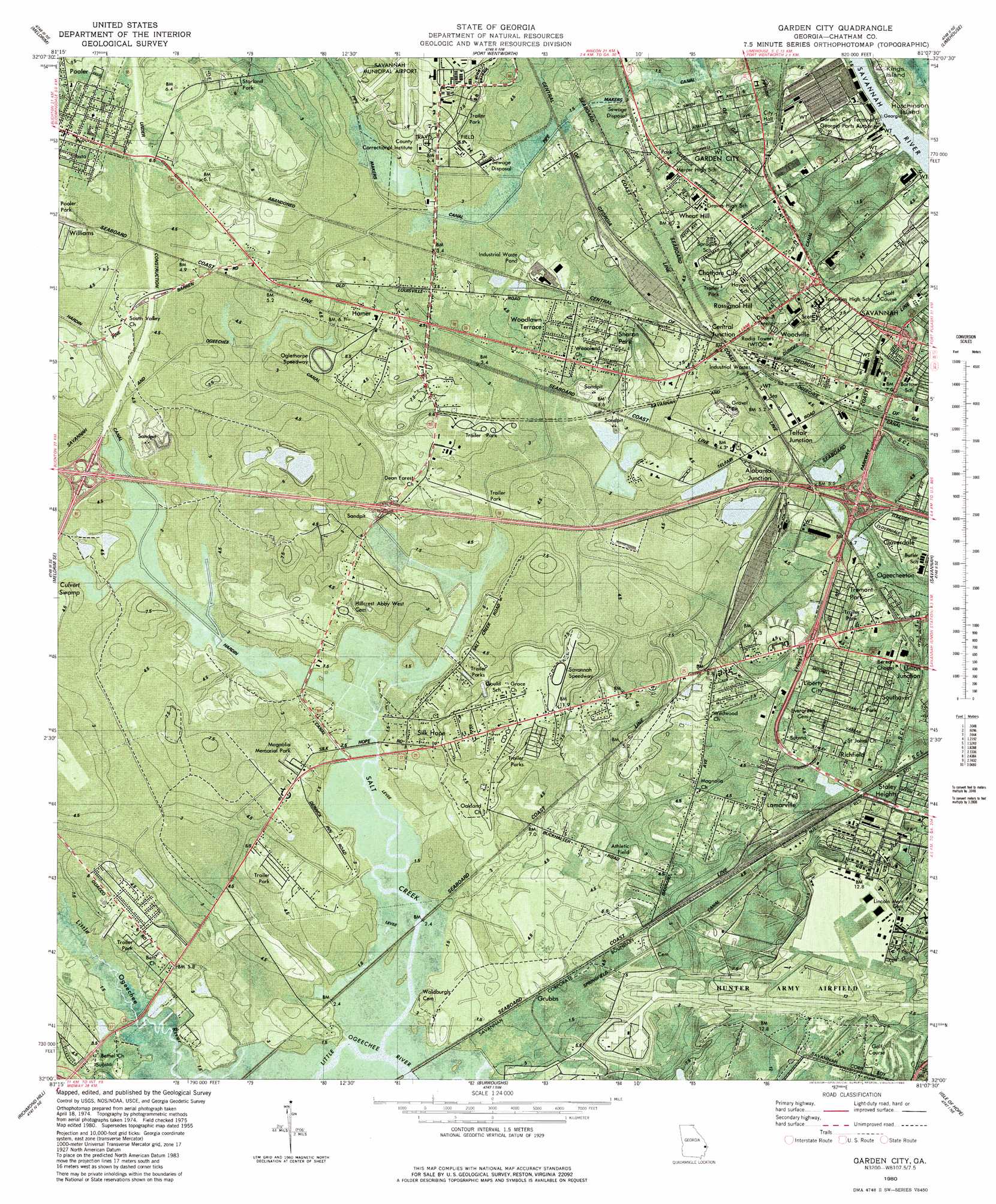
Garden City Topo Map Georgia
To zoom in, hover over the map of Garden City
USGS Topo Quad 32081a2 - 1:24,000 scale
| Topo Map Name: | Garden City |
| USGS Topo Quad ID: | 32081a2 |
| Print Size: | ca. 21 1/4" wide x 27" high |
| Southeast Coordinates: | 32° N latitude / 81.125° W longitude |
| Map Center Coordinates: | 32.0625° N latitude / 81.1875° W longitude |
| U.S. State: | GA |
| Filename: | o32081a2.jpg |
| Download Map JPG Image: | Garden City topo map 1:24,000 scale |
| Map Type: | Topographic |
| Topo Series: | 7.5´ |
| Map Scale: | 1:24,000 |
| Source of Map Images: | United States Geological Survey (USGS) |
| Alternate Map Versions: |
Garden City GA 1955, updated 1957 Download PDF Buy paper map Garden City GA 1955, updated 1973 Download PDF Buy paper map Garden City GA 1980, updated 1980 Download PDF Buy paper map Garden City GA 1980, updated 1997 Download PDF Buy paper map Garden City GA 2012 Download PDF Buy paper map Garden City GA 2014 Download PDF Buy paper map |
1:24,000 Topo Quads surrounding Garden City
Guyton |
Springfield South |
Rincon |
Hardeeville |
Jasper |
Eden |
Meldrim |
Port Wentworth |
Limehouse |
Pritchardville |
Meldrim Sw |
Meldrim Se |
Garden City |
Savannah |
Fort Pulaski |
Limerick Nw |
Richmond Hill |
Burroughs |
Isle Of Hope |
Wassaw Sound |
Dorchester |
Limerick Se |
Oak Level |
Raccoon Key |
> Back to 32081a1 at 1:100,000 scale
> Back to 32080a1 at 1:250,000 scale
> Back to U.S. Topo Maps home
Garden City topo map: Gazetteer
Garden City: Canals
Pipe Makers Canal elevation 1m 3′Savannah and Ogeechee Canal elevation 2m 6′
Garden City: Crossings
Exit 17 elevation 7m 22′Exit 18 elevation 5m 16′
Exit 32 elevation 7m 22′
Exit 33 elevation 7m 22′
Exit 34 elevation 5m 16′
Garden City: Islands
Kings Island elevation 5m 16′Garden City: Parks
Jasper Spring elevation 6m 19′Pooler Park elevation 6m 19′
Garden City: Populated Places
Alabama Junction elevation 4m 13′Azalea Plaza Mobile Home Park elevation 6m 19′
Bachelors Mobile Home Park elevation 6m 19′
Central Junction elevation 7m 22′
Chatham City elevation 7m 22′
Cloverdale elevation 4m 13′
Colony Oaks Mobile Home Park elevation 5m 16′
Dean Forest Mobile Home Park elevation 5m 16′
Florida Junction elevation 6m 19′
Foss Mobile Home Park elevation 4m 13′
Garden City elevation 5m 16′
Grubbs elevation 3m 9′
Hamer elevation 4m 13′
Lamarville elevation 5m 16′
Liberty City elevation 5m 16′
Mortons Mobile Home Park elevation 11m 36′
Ogeecheeton elevation 3m 9′
Paradise Village Mobile Home Park elevation 5m 16′
Pooler elevation 6m 19′
Richfield elevation 6m 19′
Rossignol Hill elevation 6m 19′
Savannah Pines Mobile Home Park elevation 2m 6′
Shady Acres Mobile Home Court elevation 5m 16′
Sharon Park elevation 8m 26′
Silk Hope elevation 10m 32′
Southover elevation 6m 19′
Stanford Mobile Home Park elevation 4m 13′
Starland Park elevation 5m 16′
Telfair Junction elevation 4m 13′
Tremont Park elevation 4m 13′
Union Junction elevation 6m 19′
Wheat Hill elevation 6m 19′
Woodlawn Terrace elevation 7m 22′
Woodville elevation 5m 16′
Garden City: Post Offices
Garden City Post Office elevation 6m 19′Hunter Aaf Branch Post Office elevation 12m 39′
Garden City: Streams
Salt Creek elevation 0m 0′Garden City: Swamps
Culvert Swamp elevation 3m 9′Garden City digital topo map on disk
Buy this Garden City topo map showing relief, roads, GPS coordinates and other geographical features, as a high-resolution digital map file on DVD:
South Carolina, Western North Carolina & Northeastern Georgia
Buy digital topo maps: South Carolina, Western North Carolina & Northeastern Georgia