Hardeeville Topo Map South Carolina
To zoom in, hover over the map of Hardeeville
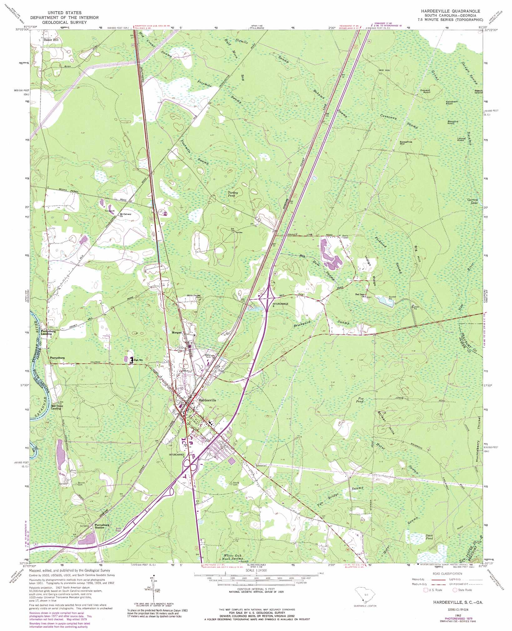
USGS Topo Quad 32081c1 - 1:24,000 scale
| Topo Map Name: | Hardeeville |
| USGS Topo Quad ID: | 32081c1 |
| Print Size: | ca. 21 1/4" wide x 27" high |
| Southeast Coordinates: | 32.25° N latitude / 81° W longitude |
| Map Center Coordinates: | 32.3125° N latitude / 81.0625° W longitude |
| U.S. States: | SC, GA |
| Filename: | o32081c1.jpg |
| Download Map JPG Image: | Hardeeville topo map 1:24,000 scale |
| Map Type: | Topographic |
| Topo Series: | 7.5´ |
| Map Scale: | 1:24,000 |
| Source of Map Images: | United States Geological Survey (USGS) |
| Alternate Map Versions: |
Hardeeville SC 1962, updated 1964 Download PDF Buy paper map Hardeeville SC 1962, updated 1979 Download PDF Buy paper map Hardeeville SC 1962, updated 1990 Download PDF Buy paper map Hardeeville SC 2011 Download PDF Buy paper map Hardeeville SC 2014 Download PDF Buy paper map |
1:24,000 Topo Quads surrounding Hardeeville
Brighton |
Pineland |
Calfpen Bay |
Coosawhatchie |
Sheldon |
Springfield North |
Hardeeville Nw |
Tillman |
Ridgeland |
Laurel Bay |
Springfield South |
Rincon |
Hardeeville |
Jasper |
Spring Island |
Meldrim |
Port Wentworth |
Limehouse |
Pritchardville |
Bluffton |
Meldrim Se |
Garden City |
Savannah |
Fort Pulaski |
Tybee Island North |
> Back to 32081a1 at 1:100,000 scale
> Back to 32080a1 at 1:250,000 scale
> Back to U.S. Topo Maps home
Hardeeville topo map: Gazetteer
Hardeeville: Crossings
Interchange 5 elevation 6m 19′Interchange 8 elevation 5m 16′
Hardeeville: Islands
Beech Island elevation 4m 13′Hardeeville: Lakes
Garrett Lake elevation 3m 9′Hardeeville: Populated Places
Baker Hill elevation 9m 29′Hardeeville elevation 8m 26′
Mill Stone Landing elevation 0m 0′
Morgan elevation 7m 22′
Purysburgh elevation 6m 19′
Purysburgh Landing elevation 2m 6′
Hardeeville: Post Offices
Hardeeville Post Office elevation 6m 19′Hardeeville: Ridges
Indigo Ridge elevation 5m 16′Hardeeville: Streams
Great Swamp elevation 3m 9′Hardeeville: Summits
Big Hill elevation 4m 13′Buzzard Knoll elevation 4m 13′
Calabash Knoll elevation 4m 13′
Laurel Knoll elevation 3m 9′
Mill Hill elevation 4m 13′
Prevent Knoll elevation 4m 13′
Sassafras Hill elevation 4m 13′
Striker Hills elevation 8m 26′
Hardeeville: Swamps
Bahama Swamp elevation 4m 13′Bob Dam Swamp elevation 4m 13′
Brickyard Swamp elevation 4m 13′
Causeway Swamp elevation 4m 13′
Duck Pond elevation 2m 6′
Fivemile Swamp elevation 5m 16′
Fourmile Swamp elevation 6m 19′
Fox Pond elevation 6m 19′
Half Moon Bay elevation 5m 16′
Hog Crawl Swamp elevation 6m 19′
Horse Swamp elevation 3m 9′
Horse Swamp elevation 2m 6′
Pickseed Swamp elevation 4m 13′
Shingle Swamp elevation 4m 13′
Sixmile Swamp elevation 4m 13′
Turkey Pond elevation 6m 19′
Two Bridge Swamp elevation 2m 6′
White Oak Nook elevation 4m 13′
Hardeeville: Woods
Huckleberry Thicket elevation 3m 9′Hardeeville digital topo map on disk
Buy this Hardeeville topo map showing relief, roads, GPS coordinates and other geographical features, as a high-resolution digital map file on DVD:
South Carolina, Western North Carolina & Northeastern Georgia
Buy digital topo maps: South Carolina, Western North Carolina & Northeastern Georgia