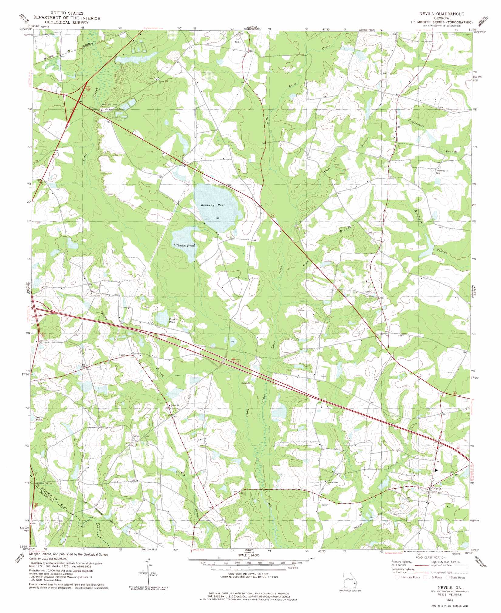
Nevils Topo Map Georgia
To zoom in, hover over the map of Nevils
USGS Topo Quad 32081c7 - 1:24,000 scale
| Topo Map Name: | Nevils |
| USGS Topo Quad ID: | 32081c7 |
| Print Size: | ca. 21 1/4" wide x 27" high |
| Southeast Coordinates: | 32.25° N latitude / 81.75° W longitude |
| Map Center Coordinates: | 32.3125° N latitude / 81.8125° W longitude |
| U.S. State: | GA |
| Filename: | o32081c7.jpg |
| Download Map JPG Image: | Nevils topo map 1:24,000 scale |
| Map Type: | Topographic |
| Topo Series: | 7.5´ |
| Map Scale: | 1:24,000 |
| Source of Map Images: | United States Geological Survey (USGS) |
| Alternate Map Versions: |
Nevils GA 1978, updated 1978 Download PDF Buy paper map Nevils GA 2011 Download PDF Buy paper map Nevils GA 2014 Download PDF Buy paper map |
1:24,000 Topo Quads surrounding Nevils
Twin City Se |
Portal |
Hopeulikit |
Dover |
Oliver |
Metter |
Pulaski |
Statesboro |
Brooklet |
Leefield |
Metter Se |
Register |
Nevils |
Denmark |
Stilson |
Collins |
Claxton |
Daisy |
Groveland |
Lanier |
Reidsville East |
Deans Crossing |
Glissons Millpond |
Willie |
Letford |
> Back to 32081a1 at 1:100,000 scale
> Back to 32080a1 at 1:250,000 scale
> Back to U.S. Topo Maps home
Nevils topo map: Gazetteer
Nevils: Airports
Southern Ag Aviation Airport elevation 55m 180′Nevils: Bridges
Scott Creek Bridge elevation 36m 118′Nevils: Crossings
Exit 25 elevation 61m 200′Nevils: Dams
Delmus Rushing Lake Dam elevation 38m 124′Hickman Pond Dam elevation 47m 154′
Hodges Pond Dam elevation 34m 111′
Riggs Lake Dam elevation 42m 137′
Smith Pond Dam elevation 47m 154′
T K Rushing Pond Dam elevation 47m 154′
Williams Pond Dam elevation 42m 137′
Nevils: Lakes
Booth Pond elevation 41m 134′Nevils: Populated Places
Enal (historical) elevation 61m 200′Nevils elevation 62m 203′
Rushing Mobile Home Park elevation 47m 154′
Nevils: Reservoirs
Delmus Rushing Lake elevation 38m 124′Groover Pond (historical) elevation 39m 127′
Hickman Pond elevation 47m 154′
Hodges Pond elevation 34m 111′
Kennedy Pond elevation 40m 131′
Riggs Lake elevation 42m 137′
Smith Pond elevation 47m 154′
T K Rushing Pond elevation 47m 154′
Tillman Pond elevation 38m 124′
Williams Pond elevation 42m 137′
Nevils: Streams
Dam Branch elevation 41m 134′Gum Branch elevation 38m 124′
Kirby Branch elevation 33m 108′
Little Lotts Creek elevation 31m 101′
Nevils digital topo map on disk
Buy this Nevils topo map showing relief, roads, GPS coordinates and other geographical features, as a high-resolution digital map file on DVD:
South Carolina, Western North Carolina & Northeastern Georgia
Buy digital topo maps: South Carolina, Western North Carolina & Northeastern Georgia