Register Topo Map Georgia
To zoom in, hover over the map of Register
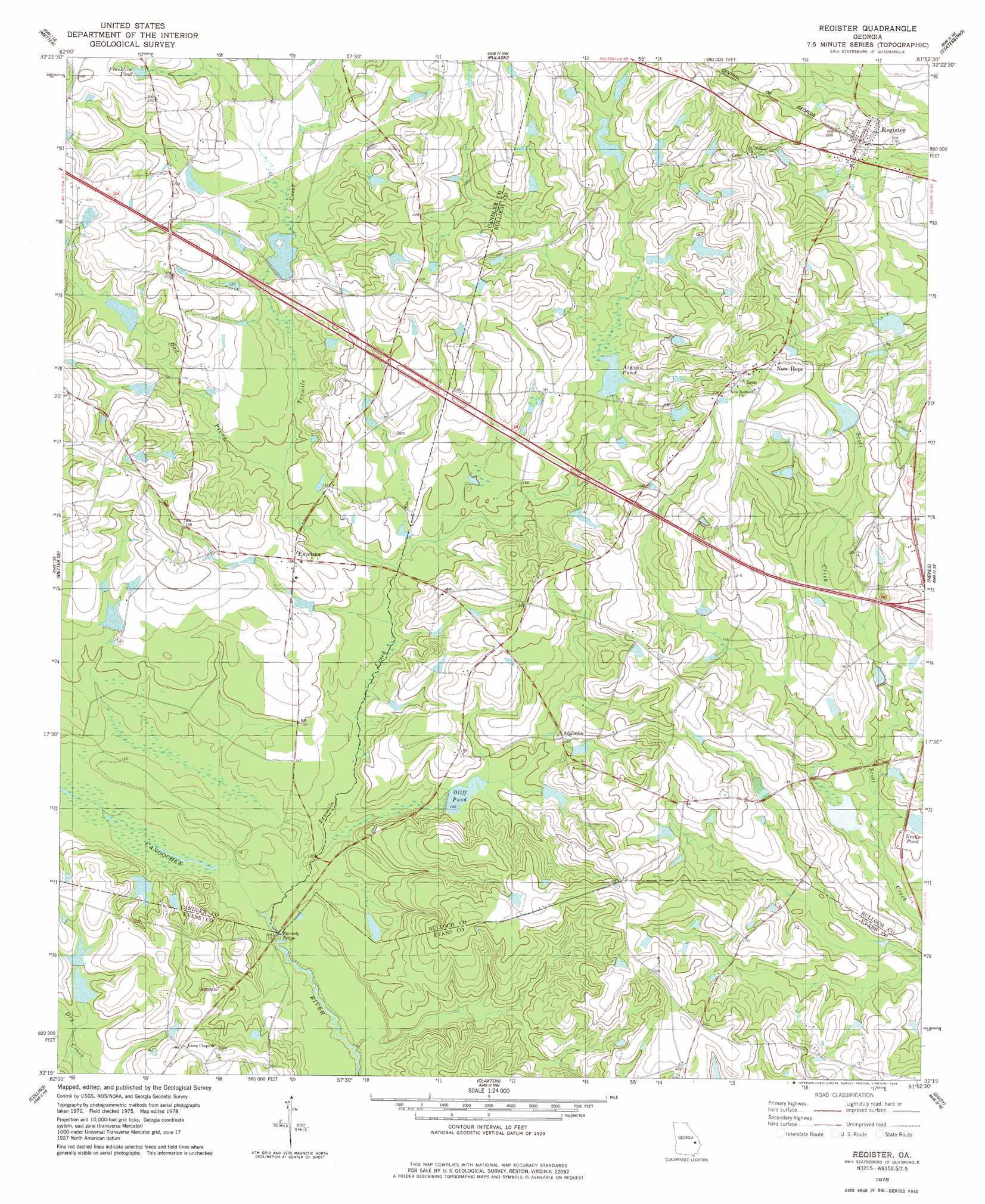
USGS Topo Quad 32081c8 - 1:24,000 scale
| Topo Map Name: | Register |
| USGS Topo Quad ID: | 32081c8 |
| Print Size: | ca. 21 1/4" wide x 27" high |
| Southeast Coordinates: | 32.25° N latitude / 81.875° W longitude |
| Map Center Coordinates: | 32.3125° N latitude / 81.9375° W longitude |
| U.S. State: | GA |
| Filename: | o32081c8.jpg |
| Download Map JPG Image: | Register topo map 1:24,000 scale |
| Map Type: | Topographic |
| Topo Series: | 7.5´ |
| Map Scale: | 1:24,000 |
| Source of Map Images: | United States Geological Survey (USGS) |
| Alternate Map Versions: |
Register GA 1978, updated 1978 Download PDF Buy paper map Register GA 2011 Download PDF Buy paper map Register GA 2014 Download PDF Buy paper map |
1:24,000 Topo Quads surrounding Register
Twin City |
Twin City Se |
Portal |
Hopeulikit |
Dover |
Stillmore |
Metter |
Pulaski |
Statesboro |
Brooklet |
Cobbtown |
Metter Se |
Register |
Nevils |
Denmark |
Ohoopee |
Collins |
Claxton |
Daisy |
Groveland |
Reidsville West |
Reidsville East |
Deans Crossing |
Glissons Millpond |
Willie |
> Back to 32081a1 at 1:100,000 scale
> Back to 32080a1 at 1:250,000 scale
> Back to U.S. Topo Maps home
Register topo map: Gazetteer
Register: Bridges
Hi-Hill Bridge elevation 43m 141′Jones Bridge elevation 48m 157′
Kennedy Bridge elevation 34m 111′
Mike Kennedy Bridge elevation 43m 141′
Register: Crossings
Exit 24 elevation 58m 190′Register: Dams
Akins Lake Dam elevation 47m 154′Atwood Pond Dam elevation 50m 164′
Cliff Pond Dam elevation 41m 134′
Deloach Lake Dam elevation 50m 164′
Great Southern Paper Company Lake Dam elevation 41m 134′
Jones Lake Dam elevation 47m 154′
Nevils Pond Dam elevation 45m 147′
Smith Lake Dam elevation 56m 183′
Sykes Lake Dam elevation 46m 150′
Sykes Lake South Dam elevation 44m 144′
Tillman Pond Dam elevation 56m 183′
Register: Lakes
Brewer Pond (historical) elevation 52m 170′Register: Populated Places
Adabelle elevation 49m 160′Excelsior elevation 51m 167′
New Hope elevation 67m 219′
Register elevation 59m 193′
Register: Reservoirs
Akins Lake elevation 47m 154′Atwood Pond elevation 50m 164′
Cliff Pond elevation 41m 134′
Deloach Lake elevation 50m 164′
Franklins Pond elevation 66m 216′
Great Southern Paper Company Lake elevation 41m 134′
Jones Lake elevation 47m 154′
Nevils Pond elevation 45m 147′
Oliff Pond elevation 43m 141′
Smith Lake elevation 56m 183′
Sykes Lake elevation 46m 150′
Sykes Lake South elevation 44m 144′
Tillman Pond elevation 56m 183′
Register: Streams
Bad Prong elevation 44m 144′Tenmile Creek elevation 33m 108′
Register digital topo map on disk
Buy this Register topo map showing relief, roads, GPS coordinates and other geographical features, as a high-resolution digital map file on DVD:
South Carolina, Western North Carolina & Northeastern Georgia
Buy digital topo maps: South Carolina, Western North Carolina & Northeastern Georgia