Hardeeville Nw Topo Map South Carolina
To zoom in, hover over the map of Hardeeville Nw
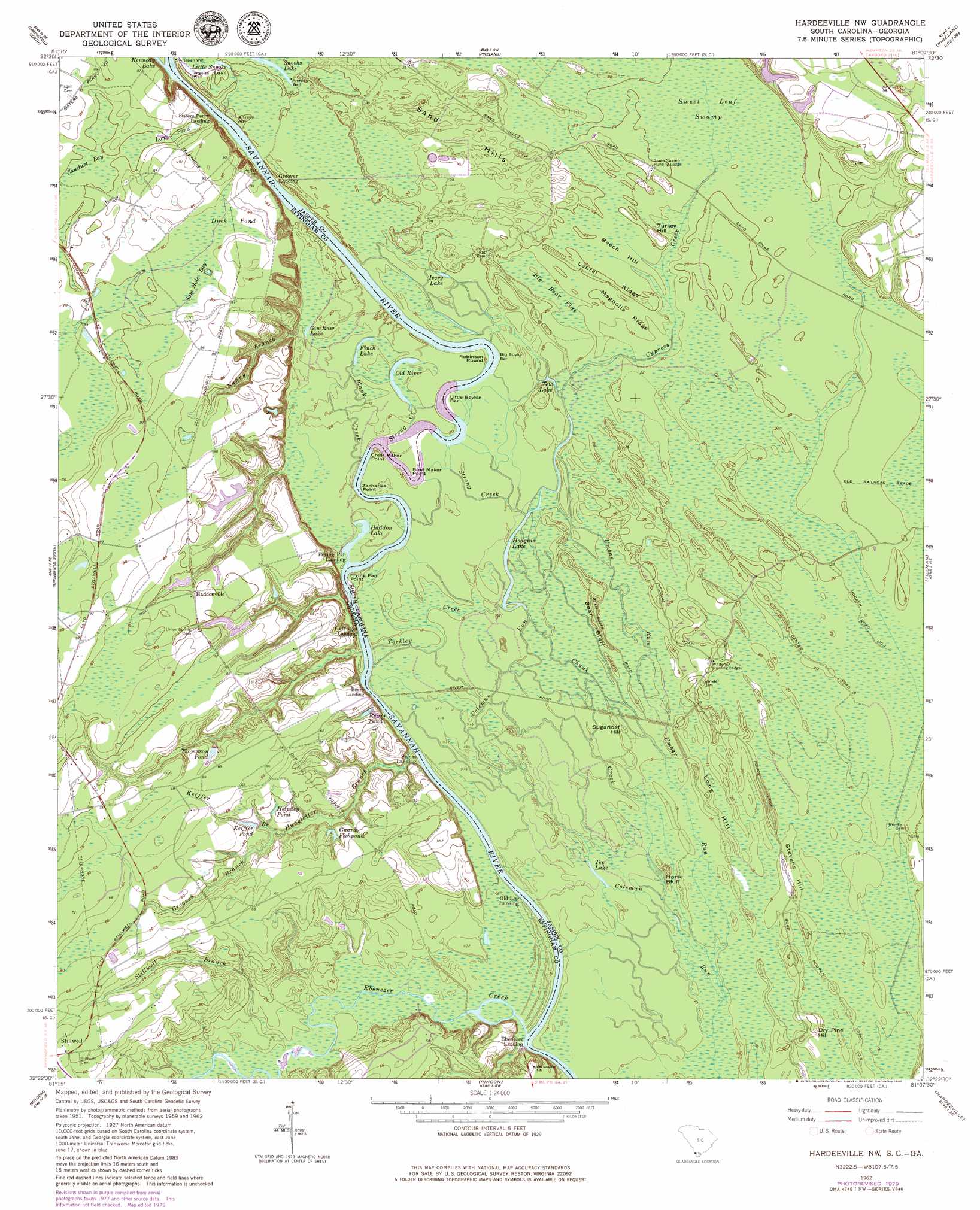
USGS Topo Quad 32081d2 - 1:24,000 scale
| Topo Map Name: | Hardeeville Nw |
| USGS Topo Quad ID: | 32081d2 |
| Print Size: | ca. 21 1/4" wide x 27" high |
| Southeast Coordinates: | 32.375° N latitude / 81.125° W longitude |
| Map Center Coordinates: | 32.4375° N latitude / 81.1875° W longitude |
| U.S. States: | SC, GA |
| Filename: | o32081d2.jpg |
| Download Map JPG Image: | Hardeeville Nw topo map 1:24,000 scale |
| Map Type: | Topographic |
| Topo Series: | 7.5´ |
| Map Scale: | 1:24,000 |
| Source of Map Images: | United States Geological Survey (USGS) |
| Alternate Map Versions: |
Hardeeville NW SC 1962, updated 1964 Download PDF Buy paper map Hardeeville NW SC 1962, updated 1980 Download PDF Buy paper map Hardeeville NW SC 2011 Download PDF Buy paper map Hardeeville NW SC 2014 Download PDF Buy paper map |
1:24,000 Topo Quads surrounding Hardeeville Nw
Blue Springs Landing |
Shirley |
Furman |
Grays |
Mcphersonville |
Kildare |
Brighton |
Pineland |
Calfpen Bay |
Coosawhatchie |
Egypt |
Springfield North |
Hardeeville Nw |
Tillman |
Ridgeland |
Guyton |
Springfield South |
Rincon |
Hardeeville |
Jasper |
Eden |
Meldrim |
Port Wentworth |
Limehouse |
Pritchardville |
> Back to 32081a1 at 1:100,000 scale
> Back to 32080a1 at 1:250,000 scale
> Back to U.S. Topo Maps home
Hardeeville Nw topo map: Gazetteer
Hardeeville Nw: Bars
Big Boykin Bar elevation 5m 16′Little Boykin Bar elevation 5m 16′
Hardeeville Nw: Bridges
Cypress Creek Bridge elevation 6m 19′Hardeeville Nw: Capes
Bowl Maker Point elevation 5m 16′Chair Maker Point elevation 5m 16′
Frying Pan Point elevation 5m 16′
Robinson Round elevation 6m 19′
Zacharias Point elevation 5m 16′
Hardeeville Nw: Cliffs
Bear Bluff elevation 9m 29′Horse Bluff elevation 3m 9′
Hardeeville Nw: Crossings
Sisters Ferry (historical) elevation 5m 16′Sisters Ferry (historical) elevation 5m 16′
Hardeeville Nw: Dams
Hoover Plantation Dam D-2592 elevation 15m 49′South Carolina Noname 27005 D-2588 Dam elevation 12m 39′
Hardeeville Nw: Lakes
Finch Lake elevation 5m 16′Gin Raw Lake elevation 6m 19′
Haddon Lake elevation 4m 13′
Helmley Pond elevation 13m 42′
Hodgins Lake elevation 4m 13′
Ivory Lake elevation 7m 22′
Keiffer Pond elevation 13m 42′
Little Snooks Lake elevation 7m 22′
Old River elevation 5m 16′
Reiser Pond elevation 11m 36′
Snooks Lake elevation 7m 22′
Tee Lake elevation 4m 13′
Tew Lake elevation 6m 19′
Hardeeville Nw: Populated Places
Berrys Landing elevation 5m 16′Ebenezer elevation 14m 45′
Groover Landing elevation 7m 22′
Haddonville elevation 23m 75′
Hardeeville Nw: Reservoirs
Gnann Fishpond elevation 12m 39′Thompson Pond elevation 17m 55′
Hardeeville Nw: Ridges
Laurel Ridge elevation 7m 22′Magnolia Ridge elevation 7m 22′
Hardeeville Nw: Streams
Chunk Creek elevation 3m 9′Cypress Creek elevation 4m 13′
Ebenezer Creek elevation 3m 9′
Groover Branch elevation 8m 26′
Hungleiter Branch elevation 4m 13′
Keiffer Branch elevation 7m 22′
Nanny Branch elevation 6m 19′
Plank Creek elevation 4m 13′
Stillwell Branch elevation 4m 13′
Strong Creek elevation 4m 13′
Strong Creek elevation 5m 16′
Umbar Run elevation 3m 9′
Willow Swamp elevation 5m 16′
Yorkley Creek elevation 4m 13′
Hardeeville Nw: Summits
Beech Hill elevation 6m 19′Dry Pine Hill elevation 9m 29′
Long Hill elevation 8m 26′
Stevens Hill elevation 8m 26′
Sugarloaf Hill elevation 6m 19′
Turkey Hill elevation 6m 19′
Hardeeville Nw: Swamps
Big Boar Flat elevation 6m 19′Duck Pond elevation 23m 75′
Long Pond elevation 22m 72′
Sam Hole Bay elevation 24m 78′
Sawdust Bay elevation 22m 72′
Sweet Leaf Swamp elevation 7m 22′
Hardeeville Nw digital topo map on disk
Buy this Hardeeville Nw topo map showing relief, roads, GPS coordinates and other geographical features, as a high-resolution digital map file on DVD:
South Carolina, Western North Carolina & Northeastern Georgia
Buy digital topo maps: South Carolina, Western North Carolina & Northeastern Georgia