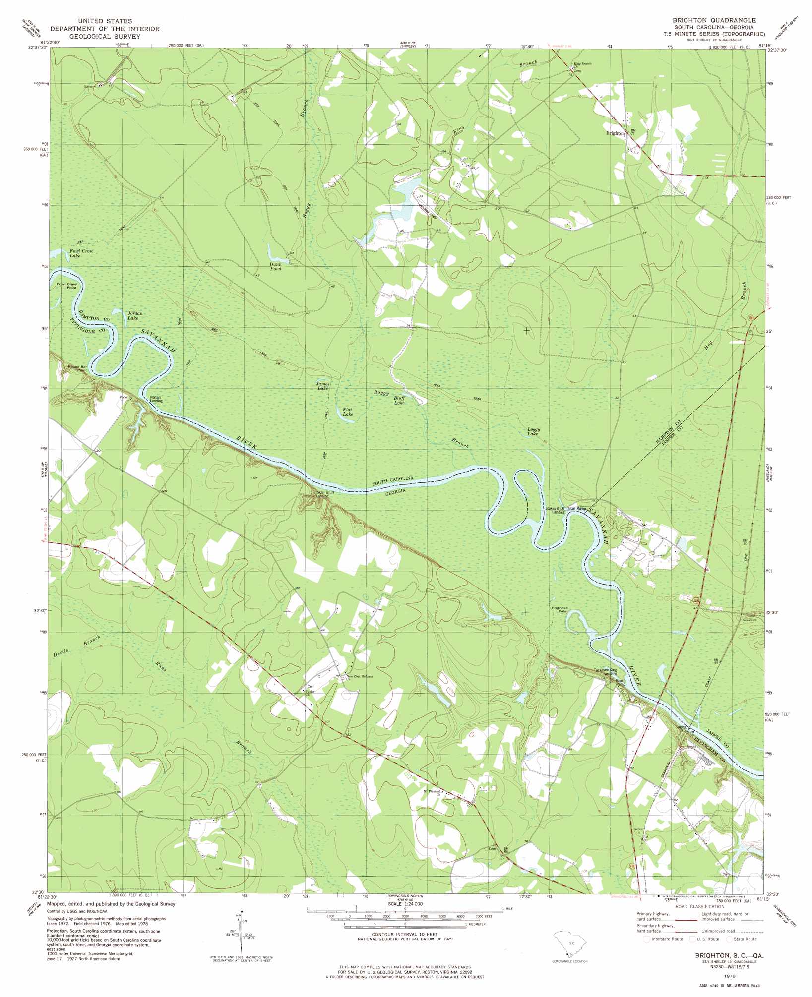
Brighton Topo Map South Carolina
To zoom in, hover over the map of Brighton
USGS Topo Quad 32081e3 - 1:24,000 scale
| Topo Map Name: | Brighton |
| USGS Topo Quad ID: | 32081e3 |
| Print Size: | ca. 21 1/4" wide x 27" high |
| Southeast Coordinates: | 32.5° N latitude / 81.25° W longitude |
| Map Center Coordinates: | 32.5625° N latitude / 81.3125° W longitude |
| U.S. States: | SC, GA |
| Filename: | o32081e3.jpg |
| Download Map JPG Image: | Brighton topo map 1:24,000 scale |
| Map Type: | Topographic |
| Topo Series: | 7.5´ |
| Map Scale: | 1:24,000 |
| Source of Map Images: | United States Geological Survey (USGS) |
| Alternate Map Versions: |
Brighton SC 1978, updated 1978 Download PDF Buy paper map Brighton SC 2011 Download PDF Buy paper map Brighton SC 2014 Download PDF Buy paper map |
1:24,000 Topo Quads surrounding Brighton
Jacksonboro Bridge |
Brier Creek Landing |
Solomons Crossroads |
Gifford |
Hampton |
Hunters |
Blue Springs Landing |
Shirley |
Furman |
Grays |
Oliver |
Kildare |
Brighton |
Pineland |
Calfpen Bay |
Leefield |
Egypt |
Springfield North |
Hardeeville Nw |
Tillman |
Stilson |
Guyton |
Springfield South |
Rincon |
Hardeeville |
> Back to 32081e1 at 1:100,000 scale
> Back to 32080a1 at 1:250,000 scale
> Back to U.S. Topo Maps home
Brighton topo map: Gazetteer
Brighton: Capes
Fowl Craw Point elevation 8m 26′Hognose Point elevation 6m 19′
Rabbit Bar Point elevation 8m 26′
Sandy Point elevation 7m 22′
Brighton: Channels
Goldwires Reach elevation 7m 22′Goldwires Reach elevation 7m 22′
Brighton: Cliffs
Palichucola Bluff elevation 6m 19′Stokes Bluff elevation 9m 29′
Brighton: Dams
Hodges Pond Dam elevation 7m 22′Lakeside Farms Pond Dam elevation 20m 65′
Wildlife Lake Number One D-2609 Dam elevation 14m 45′
Wildlife Lake Number Two D-2610 Dam elevation 11m 36′
Brighton: Lakes
Bluff Lake elevation 7m 22′Camel Lake elevation 6m 19′
Flat Lake elevation 8m 26′
Fowl Craw Lake elevation 7m 22′
James Lake elevation 9m 29′
Jordan Lake elevation 8m 26′
Loggy Lake elevation 9m 29′
Webster Lake elevation 8m 26′
Brighton: Parks
James W Webb Wildlife Center and Game Management Area elevation 12m 39′Brighton: Populated Places
Brighton elevation 21m 68′Myers (historical) elevation 12m 39′
Stokes Bluff Landing elevation 6m 19′
Brighton: Reservoirs
Dunn Pond elevation 12m 39′Hodges Pond elevation 7m 22′
Lakeside Farms Pond elevation 20m 65′
Brighton: Streams
Boggy Branch elevation 6m 19′Devils Branch elevation 24m 78′
Hog Branch elevation 9m 29′
King Branch elevation 12m 39′
Manigault Branch elevation 11m 36′
Brighton: Swamps
Boggy Swamp elevation 10m 32′Brighton digital topo map on disk
Buy this Brighton topo map showing relief, roads, GPS coordinates and other geographical features, as a high-resolution digital map file on DVD:
South Carolina, Western North Carolina & Northeastern Georgia
Buy digital topo maps: South Carolina, Western North Carolina & Northeastern Georgia