Perkins Topo Map Georgia
To zoom in, hover over the map of Perkins
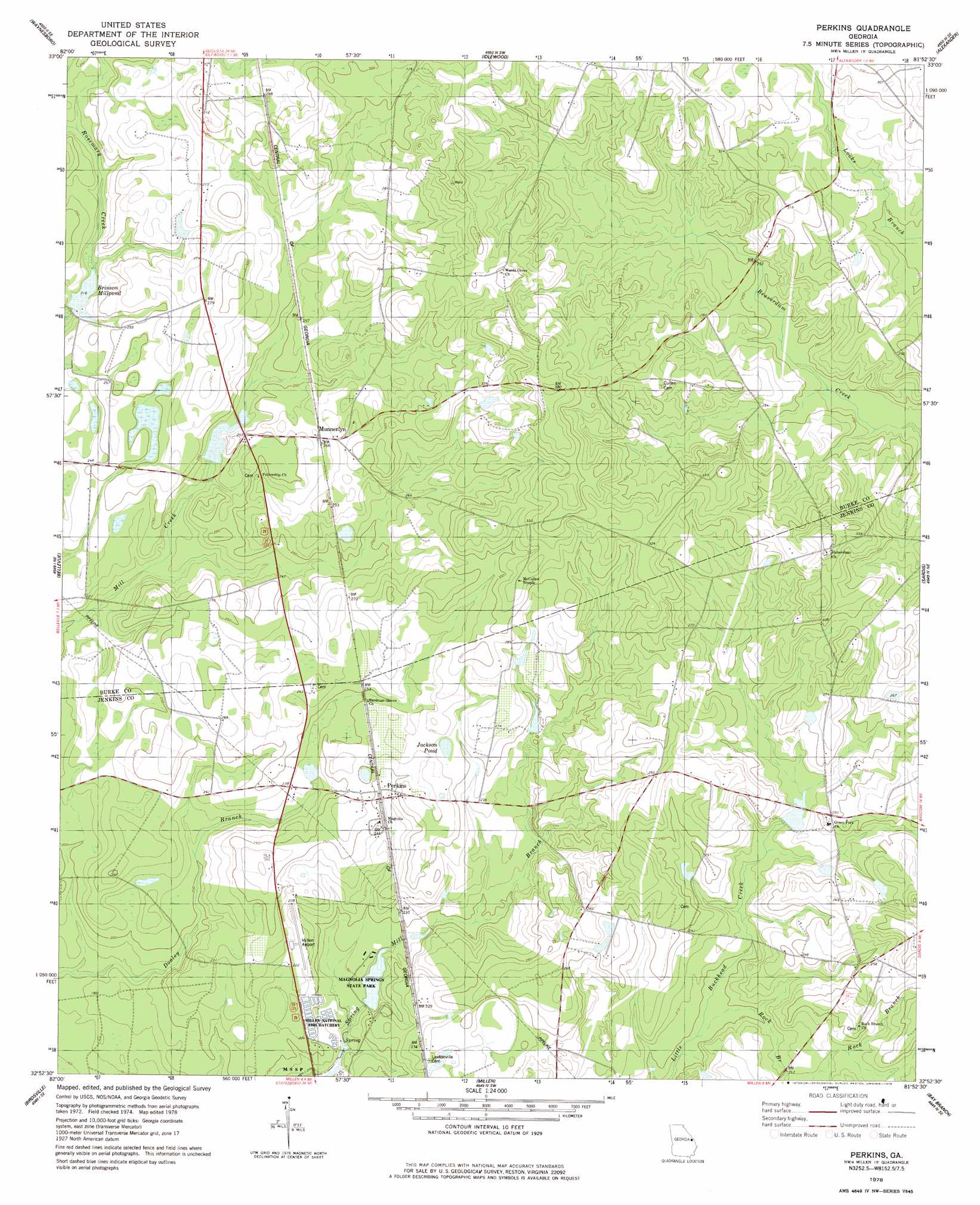
USGS Topo Quad 32081h8 - 1:24,000 scale
| Topo Map Name: | Perkins |
| USGS Topo Quad ID: | 32081h8 |
| Print Size: | ca. 21 1/4" wide x 27" high |
| Southeast Coordinates: | 32.875° N latitude / 81.875° W longitude |
| Map Center Coordinates: | 32.9375° N latitude / 81.9375° W longitude |
| U.S. State: | GA |
| Filename: | o32081h8.jpg |
| Download Map JPG Image: | Perkins topo map 1:24,000 scale |
| Map Type: | Topographic |
| Topo Series: | 7.5´ |
| Map Scale: | 1:24,000 |
| Source of Map Images: | United States Geological Survey (USGS) |
| Alternate Map Versions: |
Perkins GA 1978, updated 1978 Download PDF Buy paper map Perkins GA 2011 Download PDF Buy paper map Perkins GA 2014 Download PDF Buy paper map |
1:24,000 Topo Quads surrounding Perkins
Keysville |
Storys Millpond |
Mcbean |
Shell Bluff Landing |
Girard Nw |
Gough |
Waynesboro |
Idlewood |
Alexander |
Girard |
Scotts Corner |
Bellevue |
Perkins |
Sardis |
Hilltonia |
Midville |
Birdsville |
Millen |
Bay Branch |
Sylvania North |
Canoochee |
Garfield |
Four Points |
Rocky Ford |
Sylvania South |
> Back to 32081e1 at 1:100,000 scale
> Back to 32080a1 at 1:250,000 scale
> Back to U.S. Topo Maps home
Perkins topo map: Gazetteer
Perkins: Airports
Millen Airport elevation 68m 223′Perkins: Dams
Brinson Millpond Dam elevation 65m 213′Jenkins Lake Dam elevation 69m 226′
Magnolia Springs State Park Dam elevation 53m 173′
Magnolia View Lake Dam elevation 64m 209′
Wood Pond Dam elevation 79m 259′
Perkins: Lakes
Jackson Pond elevation 78m 255′Perkins: Parks
Magnolia Springs State Park elevation 54m 177′Perkins: Populated Places
Habersham (historical) elevation 103m 337′Munnerlyn elevation 81m 265′
Perkins elevation 73m 239′
Wilsons Store elevation 75m 246′
Perkins: Post Offices
Perkins Post Office elevation 75m 246′Perkins: Reservoirs
Brinson Millpond elevation 65m 213′Jenkins Lake elevation 69m 226′
Magnolia Springs State Park Lake elevation 53m 173′
Magnolia View Lake elevation 64m 209′
Wood Pond elevation 79m 259′
Perkins: Springs
Magnolia Spring elevation 51m 167′Perkins: Streams
Rock Branch elevation 58m 190′Perkins digital topo map on disk
Buy this Perkins topo map showing relief, roads, GPS coordinates and other geographical features, as a high-resolution digital map file on DVD:
South Carolina, Western North Carolina & Northeastern Georgia
Buy digital topo maps: South Carolina, Western North Carolina & Northeastern Georgia