Reidsville West Topo Map Georgia
To zoom in, hover over the map of Reidsville West
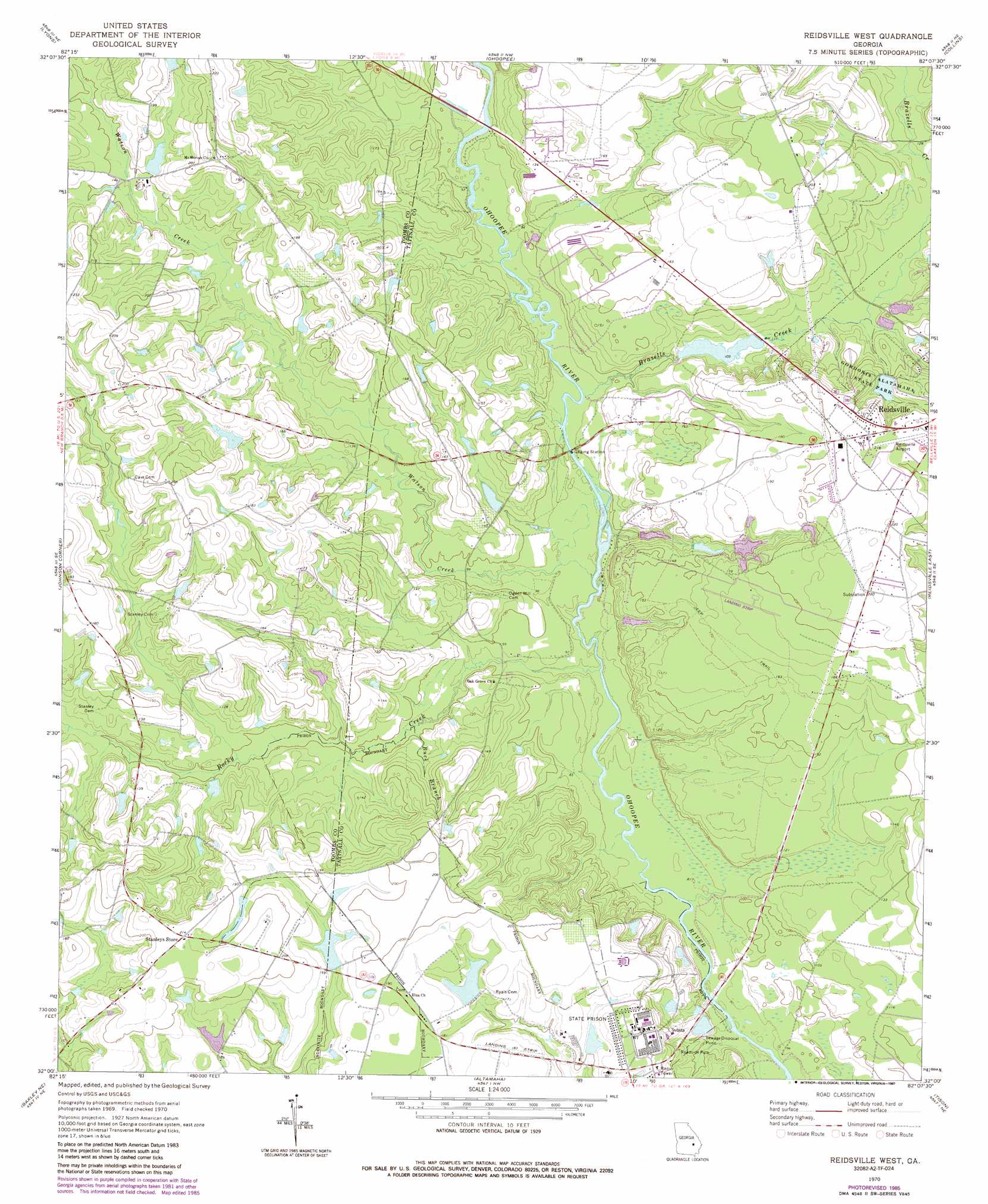
USGS Topo Quad 32082a2 - 1:24,000 scale
| Topo Map Name: | Reidsville West |
| USGS Topo Quad ID: | 32082a2 |
| Print Size: | ca. 21 1/4" wide x 27" high |
| Southeast Coordinates: | 32° N latitude / 82.125° W longitude |
| Map Center Coordinates: | 32.0625° N latitude / 82.1875° W longitude |
| U.S. State: | GA |
| Filename: | o32082a2.jpg |
| Download Map JPG Image: | Reidsville West topo map 1:24,000 scale |
| Map Type: | Topographic |
| Topo Series: | 7.5´ |
| Map Scale: | 1:24,000 |
| Source of Map Images: | United States Geological Survey (USGS) |
| Alternate Map Versions: |
Reidsville West GA 1970, updated 1973 Download PDF Buy paper map Reidsville West GA 1970, updated 1986 Download PDF Buy paper map Reidsville West GA 1970, updated 1987 Download PDF Buy paper map Reidsville West GA 2011 Download PDF Buy paper map Reidsville West GA 2014 Download PDF Buy paper map |
1:24,000 Topo Quads surrounding Reidsville West
Oak Park Sw |
Oak Park |
Cobbtown |
Metter Se |
Register |
Vidalia |
Lyons |
Ohoopee |
Collins |
Claxton |
Alston |
Johnson Corner |
Reidsville West |
Reidsville East |
Deans Crossing |
Grays Landing |
Baxley Ne |
Altamaha |
Tison |
Glennville |
Pine Grove |
Baxley |
Altamaha Sw |
Altamaha Se |
Glennville Sw |
> Back to 32082a1 at 1:100,000 scale
> Back to 32082a1 at 1:250,000 scale
> Back to U.S. Topo Maps home
Reidsville West topo map: Gazetteer
Reidsville West: Airports
Reidsville Airport elevation 56m 183′Reidsville West: Bridges
Ryals Bridge (historical) elevation 23m 75′Shepards Bridge elevation 27m 88′
Stanley Ford Bridge elevation 30m 98′
Reidsville West: Dams
Bowen Lake Dam elevation 44m 144′Chicken Yard Pond Dam elevation 47m 154′
Cone Lake Dam elevation 47m 154′
Gordonia Alatamaha Lake Dam elevation 47m 154′
Wardens Cabin Pond Dam elevation 50m 164′
Weyherhauser Dam elevation 54m 177′
Winge Lake Dam elevation 30m 98′
Reidsville West: Parks
Gordonia Alatamaha State Park elevation 52m 170′Reidsville West: Reservoirs
Bowens Pond elevation 44m 144′Chicken Yard Pond elevation 47m 154′
Cone Lake elevation 47m 154′
Gordonia Alatamaha Lake elevation 47m 154′
Wardins Cabin Pond elevation 50m 164′
Weyherhauser Lake elevation 54m 177′
Winge Lake elevation 30m 98′
Reidsville West: Streams
Brazells Creek elevation 27m 88′Buck Branch elevation 28m 91′
Rocky Creek elevation 24m 78′
Watson Creek elevation 24m 78′
Reidsville West digital topo map on disk
Buy this Reidsville West topo map showing relief, roads, GPS coordinates and other geographical features, as a high-resolution digital map file on DVD:
South Carolina, Western North Carolina & Northeastern Georgia
Buy digital topo maps: South Carolina, Western North Carolina & Northeastern Georgia