Scotland Topo Map Georgia
To zoom in, hover over the map of Scotland
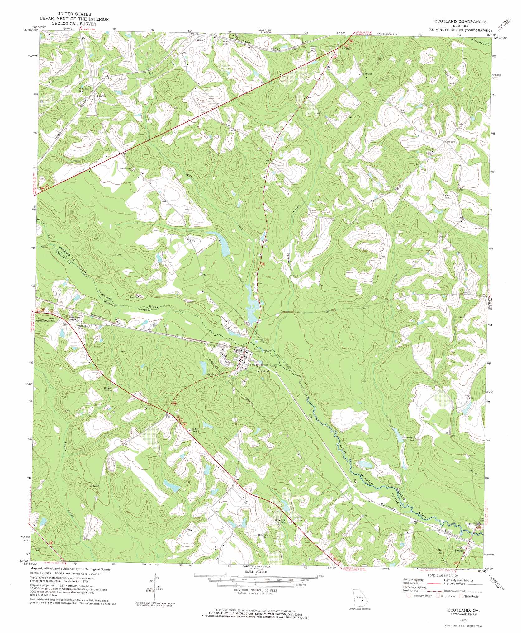
USGS Topo Quad 32082a7 - 1:24,000 scale
| Topo Map Name: | Scotland |
| USGS Topo Quad ID: | 32082a7 |
| Print Size: | ca. 21 1/4" wide x 27" high |
| Southeast Coordinates: | 32° N latitude / 82.75° W longitude |
| Map Center Coordinates: | 32.0625° N latitude / 82.8125° W longitude |
| U.S. State: | GA |
| Filename: | o32082a7.jpg |
| Download Map JPG Image: | Scotland topo map 1:24,000 scale |
| Map Type: | Topographic |
| Topo Series: | 7.5´ |
| Map Scale: | 1:24,000 |
| Source of Map Images: | United States Geological Survey (USGS) |
| Alternate Map Versions: |
Scotland GA 1970, updated 1973 Download PDF Buy paper map Scotland GA 1970, updated 1986 Download PDF Buy paper map Scotland GA 2011 Download PDF Buy paper map Scotland GA 2014 Download PDF Buy paper map |
1:24,000 Topo Quads surrounding Scotland
Cadwell |
Five Points |
Lowery |
Lothair |
Soperton South |
Jay Bird Springs |
Mcrae Nw |
Alamo |
Glenwood |
Mount Vernon |
Milan |
Mcrae |
Scotland |
Jordan |
Uvalda |
Cooks Still |
Workmore |
Jacksonville Ne |
Lumber City |
Hazlehurst North |
China Hill |
Jacksonville |
Snipesville |
Roper |
Hazlehurst South |
> Back to 32082a1 at 1:100,000 scale
> Back to 32082a1 at 1:250,000 scale
> Back to U.S. Topo Maps home
Scotland topo map: Gazetteer
Scotland: Dams
Cleggs Lake Dam elevation 44m 144′Flanders Lake Dam elevation 50m 164′
Stenson Lake Dam elevation 63m 206′
Talmadge Lake Dam elevation 64m 209′
Scotland: Populated Places
Avants elevation 79m 259′Erick elevation 82m 269′
Scotland elevation 51m 167′
Towns elevation 43m 141′
Scotland: Reservoirs
Cleggs Lake elevation 44m 144′Flanders Lake elevation 50m 164′
Stenson Lake elevation 63m 206′
Talmadge Lake elevation 64m 209′
Scotland: Streams
Little Creek elevation 42m 137′Mill Creek elevation 44m 144′
Wilcox Creek elevation 46m 150′
Scotland digital topo map on disk
Buy this Scotland topo map showing relief, roads, GPS coordinates and other geographical features, as a high-resolution digital map file on DVD:
South Carolina, Western North Carolina & Northeastern Georgia
Buy digital topo maps: South Carolina, Western North Carolina & Northeastern Georgia