Soperton South Topo Map Georgia
To zoom in, hover over the map of Soperton South
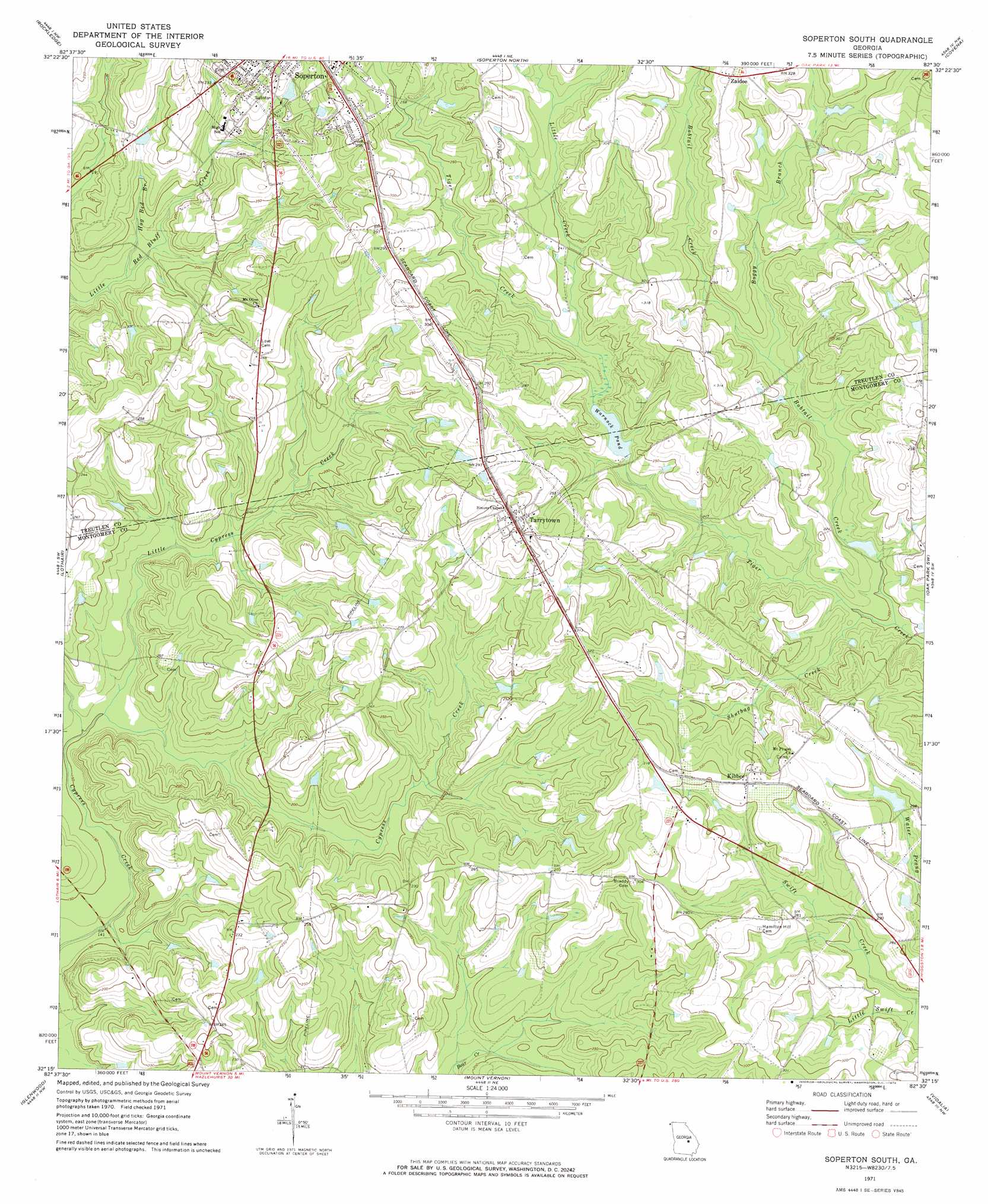
USGS Topo Quad 32082c5 - 1:24,000 scale
| Topo Map Name: | Soperton South |
| USGS Topo Quad ID: | 32082c5 |
| Print Size: | ca. 21 1/4" wide x 27" high |
| Southeast Coordinates: | 32.25° N latitude / 82.5° W longitude |
| Map Center Coordinates: | 32.3125° N latitude / 82.5625° W longitude |
| U.S. State: | GA |
| Filename: | o32082c5.jpg |
| Download Map JPG Image: | Soperton South topo map 1:24,000 scale |
| Map Type: | Topographic |
| Topo Series: | 7.5´ |
| Map Scale: | 1:24,000 |
| Source of Map Images: | United States Geological Survey (USGS) |
| Alternate Map Versions: |
Soperton South GA 1971, updated 1973 Download PDF Buy paper map Soperton South GA 2011 Download PDF Buy paper map Soperton South GA 2014 Download PDF Buy paper map |
1:24,000 Topo Quads surrounding Soperton South
East Dublin |
Scott |
Adrian |
Norristown |
Swainsboro |
Minter |
Rockledge |
Soperton North |
Covena |
Nunez |
Lowery |
Lothair |
Soperton South |
Oak Park Sw |
Oak Park |
Alamo |
Glenwood |
Mount Vernon |
Vidalia |
Lyons |
Scotland |
Jordan |
Uvalda |
Alston |
Johnson Corner |
> Back to 32082a1 at 1:100,000 scale
> Back to 32082a1 at 1:250,000 scale
> Back to U.S. Topo Maps home
Soperton South topo map: Gazetteer
Soperton South: Dams
Coleman Lake Dam elevation 64m 209′Hamilton Dam elevation 87m 285′
Warnocks Pond Dam elevation 68m 223′
Soperton South: Lakes
Warnock Pond elevation 68m 223′Soperton South: Populated Places
Kibbee elevation 95m 311′Tarrytown elevation 92m 301′
Zaidee elevation 101m 331′
Soperton South: Reservoirs
Brown Pond elevation 67m 219′Coleman Lake elevation 64m 209′
Gillis Mill Pond (historical) elevation 73m 239′
Hall Pond elevation 60m 196′
Hamilton Lake elevation 87m 285′
Sparks Pond elevation 82m 269′
Waller Pond elevation 76m 249′
Warnocks Pond elevation 66m 216′
Soperton South: Streams
Bobtail Creek elevation 60m 196′Boggy Branch elevation 68m 223′
Cypress Creek elevation 46m 150′
Hog Bed Branch elevation 50m 164′
Little Creek elevation 70m 229′
Little Cypress Creek elevation 45m 147′
Little Swift Creek elevation 70m 229′
Shotbag Creek elevation 61m 200′
Soperton South digital topo map on disk
Buy this Soperton South topo map showing relief, roads, GPS coordinates and other geographical features, as a high-resolution digital map file on DVD:
South Carolina, Western North Carolina & Northeastern Georgia
Buy digital topo maps: South Carolina, Western North Carolina & Northeastern Georgia