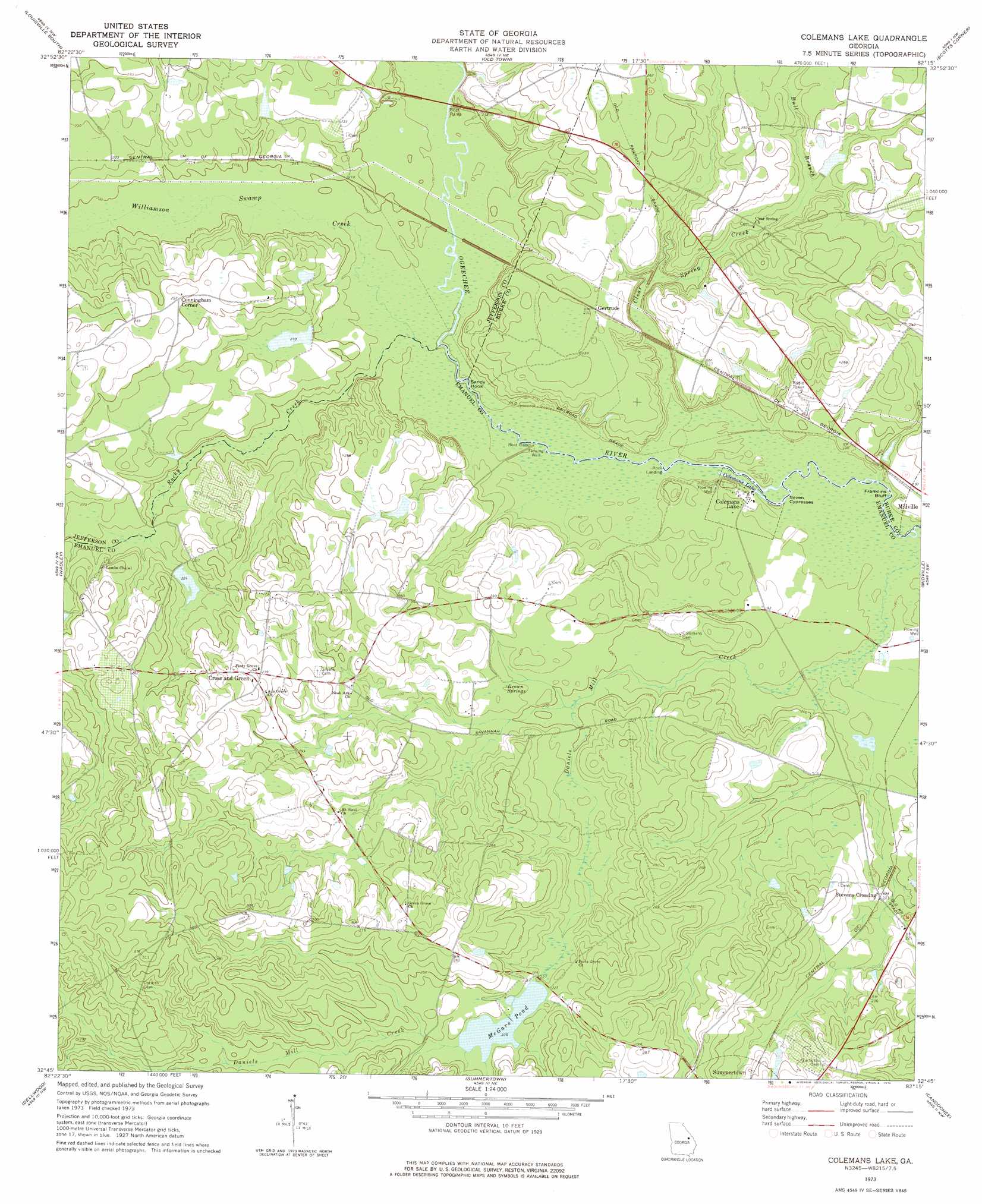
Colemans Lake Topo Map Georgia
To zoom in, hover over the map of Colemans Lake
USGS Topo Quad 32082g3 - 1:24,000 scale
| Topo Map Name: | Colemans Lake |
| USGS Topo Quad ID: | 32082g3 |
| Print Size: | ca. 21 1/4" wide x 27" high |
| Southeast Coordinates: | 32.75° N latitude / 82.25° W longitude |
| Map Center Coordinates: | 32.8125° N latitude / 82.3125° W longitude |
| U.S. State: | GA |
| Filename: | o32082g3.jpg |
| Download Map JPG Image: | Colemans Lake topo map 1:24,000 scale |
| Map Type: | Topographic |
| Topo Series: | 7.5´ |
| Map Scale: | 1:24,000 |
| Source of Map Images: | United States Geological Survey (USGS) |
| Alternate Map Versions: |
Colemans Lake GA 1973, updated 1976 Download PDF Buy paper map Colemans Lake GA 2011 Download PDF Buy paper map Colemans Lake GA 2014 Download PDF Buy paper map |
1:24,000 Topo Quads surrounding Colemans Lake
Grange |
Louisville |
Kellys Pond |
Gough |
Waynesboro |
Davisboro |
Louisville South |
Old Town |
Scotts Corner |
Bellevue |
Davisboro Se |
Wadley |
Colemans Lake |
Midville |
Birdsville |
Kite |
Dellwood |
Summertown |
Canoochee |
Garfield |
Adrian |
Norristown |
Swainsboro |
Twin City |
Twin City Se |
> Back to 32082e1 at 1:100,000 scale
> Back to 32082a1 at 1:250,000 scale
> Back to U.S. Topo Maps home
Colemans Lake topo map: Gazetteer
Colemans Lake: Bends
Sandy Hook elevation 55m 180′Seven Cypresses elevation 54m 177′
Colemans Lake: Bridges
Rayfords Bridge elevation 59m 193′Colemans Lake: Cliffs
Franklins Bluff elevation 54m 177′Colemans Lake: Dams
Beegles Pond Dam elevation 68m 223′Farmer Lake Dam elevation 71m 232′
Gambrell Lake Dam elevation 64m 209′
Mcgars Pond Dam elevation 67m 219′
McGars Pond Dam Two elevation 68m 223′
Colemans Lake: Lakes
Colemans Lake elevation 54m 177′Colemans Lake: Populated Places
Colemans Lake elevation 57m 187′Cunningham Corner elevation 77m 252′
Gertrude elevation 70m 229′
Number Ten (historical) elevation 69m 226′
Stevens Crossing elevation 64m 209′
Colemans Lake: Reservoirs
Beegles Pond elevation 68m 223′Farmer Lake elevation 71m 232′
Gambrell Lake elevation 64m 209′
McGar Pond elevation 68m 223′
McGars Pond elevation 67m 219′
Colemans Lake: Springs
Brown Springs elevation 67m 219′Colemans Lake: Streams
Bull Branch elevation 66m 216′Clear Spring Creek elevation 54m 177′
Rocky Creek elevation 55m 180′
Williamson Swamp Creek elevation 55m 180′
Colemans Lake digital topo map on disk
Buy this Colemans Lake topo map showing relief, roads, GPS coordinates and other geographical features, as a high-resolution digital map file on DVD:
South Carolina, Western North Carolina & Northeastern Georgia
Buy digital topo maps: South Carolina, Western North Carolina & Northeastern Georgia