Harrison Topo Map Georgia
To zoom in, hover over the map of Harrison
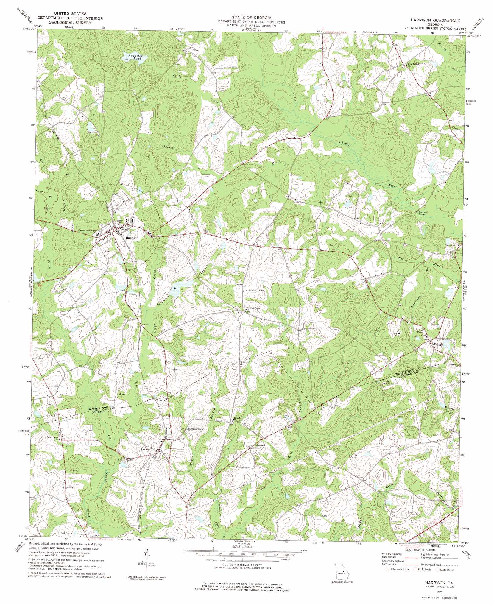
USGS Topo Quad 32082g6 - 1:24,000 scale
| Topo Map Name: | Harrison |
| USGS Topo Quad ID: | 32082g6 |
| Print Size: | ca. 21 1/4" wide x 27" high |
| Southeast Coordinates: | 32.75° N latitude / 82.625° W longitude |
| Map Center Coordinates: | 32.8125° N latitude / 82.6875° W longitude |
| U.S. State: | GA |
| Filename: | o32082g6.jpg |
| Download Map JPG Image: | Harrison topo map 1:24,000 scale |
| Map Type: | Topographic |
| Topo Series: | 7.5´ |
| Map Scale: | 1:24,000 |
| Source of Map Images: | United States Geological Survey (USGS) |
| Alternate Map Versions: |
Harrison GA 1973, updated 1976 Download PDF Buy paper map Harrison GA 2011 Download PDF Buy paper map Harrison GA 2014 Download PDF Buy paper map |
1:24,000 Topo Quads surrounding Harrison
Deepstep |
Warthen |
Downs |
Grange |
Louisville |
Tabernacle |
Sandersville |
Riddleville |
Davisboro |
Louisville South |
Oconee |
Irwins Crossroads |
Harrison |
Davisboro Se |
Wadley |
Cow Hell Swamp |
Lovett |
Wrightsville |
Kite |
Dellwood |
Dublin |
East Dublin |
Scott |
Adrian |
Norristown |
> Back to 32082e1 at 1:100,000 scale
> Back to 32082a1 at 1:250,000 scale
> Back to U.S. Topo Maps home
Harrison topo map: Gazetteer
Harrison: Bridges
Jackson Bridge elevation 96m 314′Robinson Bridge elevation 91m 298′
Harrison: Dams
Boatright Lake Dam elevation 105m 344′Brantley Pond Dam elevation 114m 374′
Jackson Lake Dam elevation 98m 321′
Segars Lake Dam elevation 110m 360′
Segars Lake Dam elevation 122m 400′
Harrison: Lakes
Brentley Pond elevation 114m 374′Harrison: Populated Places
Donovan elevation 113m 370′Harrison elevation 125m 410′
Pringle elevation 113m 370′
Harrison: Reservoirs
Boatright Lake elevation 105m 344′Brantley Pond elevation 114m 374′
Jackson Lake elevation 98m 321′
Segars Lake elevation 110m 360′
Segars Lake elevation 122m 400′
Harrison: Streams
Baker Branch elevation 90m 295′Golden Creek elevation 93m 305′
Griffith Branch elevation 103m 337′
Harrison Branch elevation 91m 298′
Little Cedar Creek elevation 91m 298′
Little Golden Creek elevation 94m 308′
Long Branch elevation 104m 341′
Red Hill Branch elevation 90m 295′
Rocky Creek elevation 97m 318′
Salt Log Branch elevation 97m 318′
Sheppard Branch elevation 99m 324′
Harrison digital topo map on disk
Buy this Harrison topo map showing relief, roads, GPS coordinates and other geographical features, as a high-resolution digital map file on DVD:
South Carolina, Western North Carolina & Northeastern Georgia
Buy digital topo maps: South Carolina, Western North Carolina & Northeastern Georgia