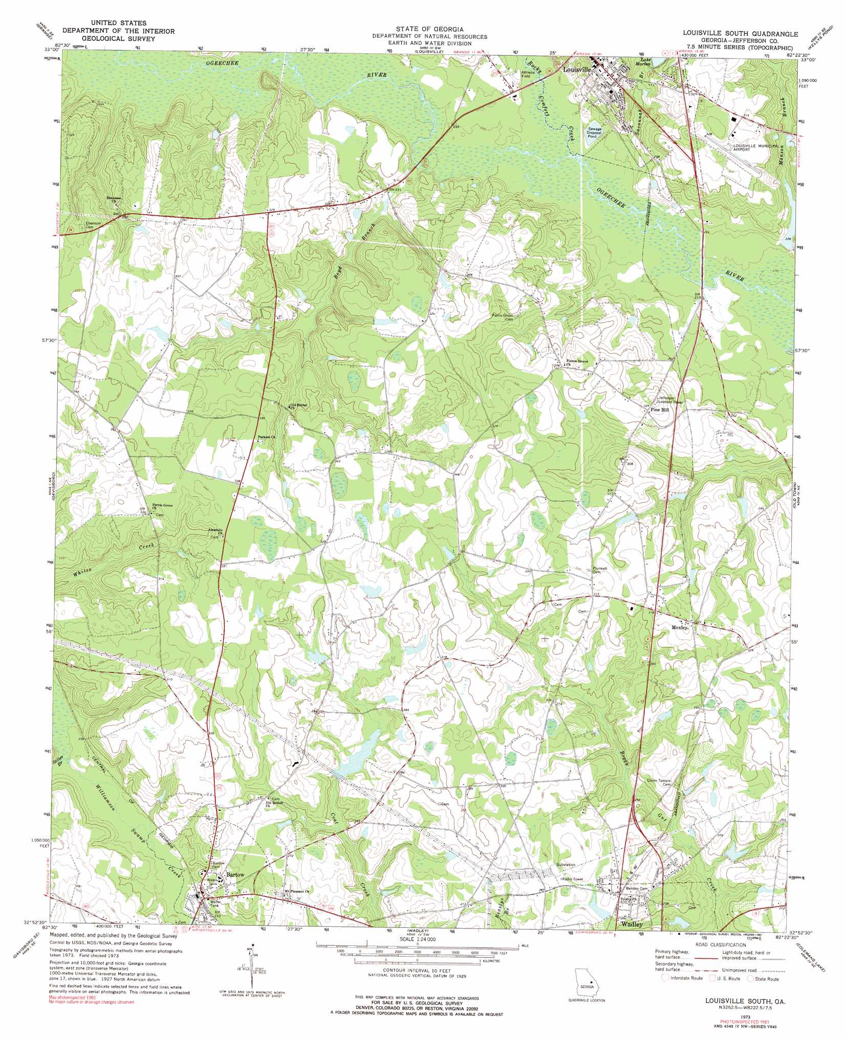
Louisville South Topo Map Georgia
To zoom in, hover over the map of Louisville South
USGS Topo Quad 32082h4 - 1:24,000 scale
| Topo Map Name: | Louisville South |
| USGS Topo Quad ID: | 32082h4 |
| Print Size: | ca. 21 1/4" wide x 27" high |
| Southeast Coordinates: | 32.875° N latitude / 82.375° W longitude |
| Map Center Coordinates: | 32.9375° N latitude / 82.4375° W longitude |
| U.S. State: | GA |
| Filename: | o32082h4.jpg |
| Download Map JPG Image: | Louisville South topo map 1:24,000 scale |
| Map Type: | Topographic |
| Topo Series: | 7.5´ |
| Map Scale: | 1:24,000 |
| Source of Map Images: | United States Geological Survey (USGS) |
| Alternate Map Versions: |
Louisville South GA 1973, updated 1976 Download PDF Buy paper map Louisville South GA 1973, updated 1991 Download PDF Buy paper map Louisville South GA 2011 Download PDF Buy paper map Louisville South GA 2014 Download PDF Buy paper map |
1:24,000 Topo Quads surrounding Louisville South
Mitchell |
Gibson |
Wrens |
Matthews |
Keysville |
Downs |
Grange |
Louisville |
Kellys Pond |
Gough |
Riddleville |
Davisboro |
Louisville South |
Old Town |
Scotts Corner |
Harrison |
Davisboro Se |
Wadley |
Colemans Lake |
Midville |
Wrightsville |
Kite |
Dellwood |
Summertown |
Canoochee |
> Back to 32082e1 at 1:100,000 scale
> Back to 32082a1 at 1:250,000 scale
> Back to U.S. Topo Maps home
Louisville South topo map: Gazetteer
Louisville South: Airports
Louisville Municipal Airport elevation 95m 311′Louisville South: Dams
Battle Pond Dam elevation 79m 259′Cobb Lake Dam elevation 96m 314′
Kelly Lake Dam elevation 69m 226′
McNeely Lake Dam elevation 81m 265′
Smith Lake Dam elevation 78m 255′
Thomas Lake Dam elevation 81m 265′
Weeks Lake Dam elevation 71m 232′
Louisville South: Populated Places
Aldreds elevation 84m 275′Bartow elevation 74m 242′
Moxley elevation 98m 321′
Pine Hill elevation 97m 318′
Louisville South: Post Offices
Bartow Post Office elevation 73m 239′Louisville South: Reservoirs
Battle Pond elevation 79m 259′Cobb Lake elevation 96m 314′
Kelly Lake elevation 69m 226′
Lake Marion elevation 84m 275′
McNeely Lake elevation 81m 265′
Smith Lake elevation 78m 255′
Thomas Lake elevation 81m 265′
Weeks Lake elevation 71m 232′
Louisville South: Streams
Boyd Branch elevation 66m 216′Manson Branch elevation 64m 209′
Rocky Comfort Creek elevation 65m 213′
Salter Branch elevation 69m 226′
Savannah Branch elevation 66m 216′
Louisville South digital topo map on disk
Buy this Louisville South topo map showing relief, roads, GPS coordinates and other geographical features, as a high-resolution digital map file on DVD:
South Carolina, Western North Carolina & Northeastern Georgia
Buy digital topo maps: South Carolina, Western North Carolina & Northeastern Georgia