Hawkinsville Topo Map Georgia
To zoom in, hover over the map of Hawkinsville
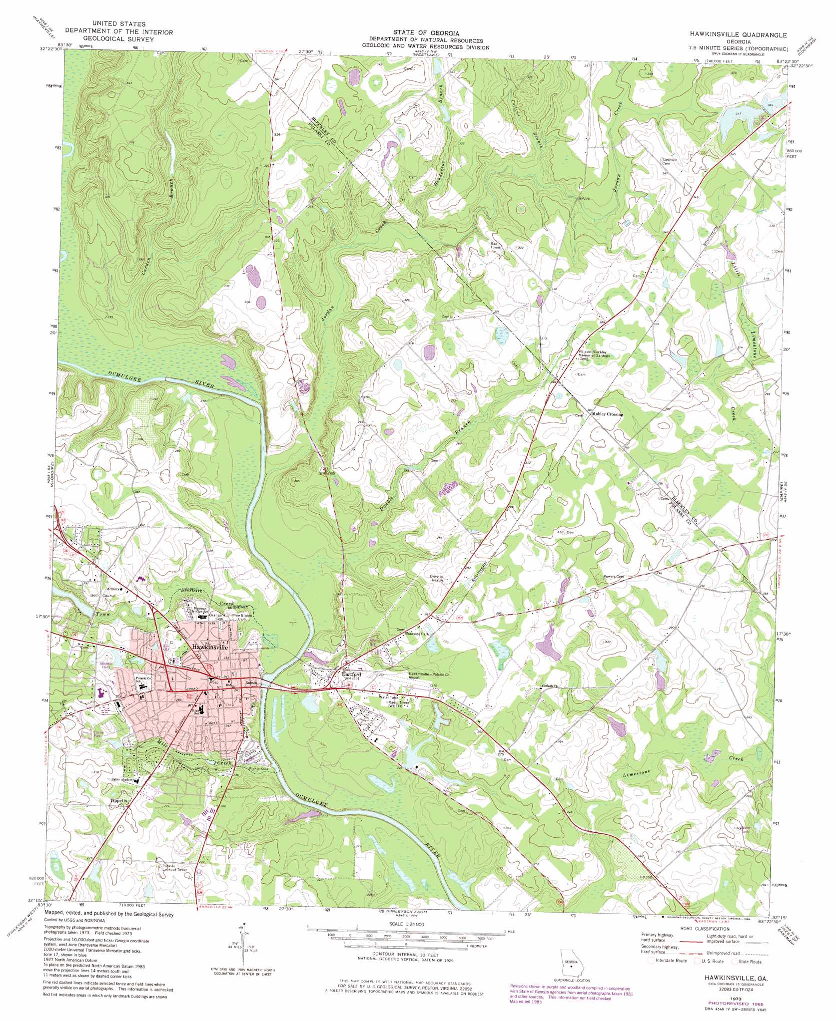
USGS Topo Quad 32083c4 - 1:24,000 scale
| Topo Map Name: | Hawkinsville |
| USGS Topo Quad ID: | 32083c4 |
| Print Size: | ca. 21 1/4" wide x 27" high |
| Southeast Coordinates: | 32.25° N latitude / 83.375° W longitude |
| Map Center Coordinates: | 32.3125° N latitude / 83.4375° W longitude |
| U.S. State: | GA |
| Filename: | o32083c4.jpg |
| Download Map JPG Image: | Hawkinsville topo map 1:24,000 scale |
| Map Type: | Topographic |
| Topo Series: | 7.5´ |
| Map Scale: | 1:24,000 |
| Source of Map Images: | United States Geological Survey (USGS) |
| Alternate Map Versions: |
Hawkinsville GA 1973, updated 1977 Download PDF Buy paper map Hawkinsville GA 1973, updated 1986 Download PDF Buy paper map Hawkinsville GA 2011 Download PDF Buy paper map Hawkinsville GA 2014 Download PDF Buy paper map |
1:24,000 Topo Quads surrounding Hawkinsville
Warner Robins Sw |
Warner Robins Se |
Tarversville |
Danville West |
Danville East |
Perry East |
Hayneville |
Westlake |
Cochran |
Chester |
Unadilla |
Klondike |
Hawkinsville |
Empire |
Yonkers |
Pineview Nw |
Finleyson West |
Finleyson East |
West Of Eastman |
Eastman |
Pineview Sw |
Pineview West |
Pineview East |
Abbeville North |
Lake Cypress |
> Back to 32083a1 at 1:100,000 scale
> Back to 32082a1 at 1:250,000 scale
> Back to U.S. Topo Maps home
Hawkinsville topo map: Gazetteer
Hawkinsville: Airports
Hawkinsville-Pulaski County Airport elevation 76m 249′Hawkinsville: Bridges
Roger H Lawson Memorial Bridge elevation 61m 200′Hawkinsville: Cliffs
Prichards Bluff elevation 67m 219′Taylors Bluff elevation 69m 226′
Hawkinsville: Dams
Bembry Lake Dam elevation 71m 232′Harris Dam elevation 100m 328′
North Royce Lake Dam elevation 78m 255′
Smith Dam elevation 96m 314′
South Royce Lake Dam elevation 78m 255′
Suzies Lake Dam elevation 69m 226′
Town Creek Country Club Lake Dam elevation 73m 239′
Hawkinsville: Parks
Hawkinsville State Park elevation 65m 213′Pulaski County Fairgrounds elevation 69m 226′
Hawkinsville: Populated Places
Hartford elevation 78m 255′Hawkinsville elevation 78m 255′
Mobley Crossing elevation 94m 308′
Tippetts elevation 91m 298′
Hawkinsville: Post Offices
Hawkinsville Post Office elevation 74m 242′Hawkinsville: Reservoirs
Bembry Lake elevation 71m 232′Harris Lake elevation 100m 328′
North Royce Lake elevation 78m 255′
Smith Lake elevation 96m 314′
South Royce Lake elevation 78m 255′
Suzies Lake elevation 69m 226′
Town Creek Country Club Lake elevation 73m 239′
Hawkinsville: Streams
Carden Branch elevation 64m 209′Collins Branch elevation 80m 262′
Double Branch elevation 62m 203′
Henderson Branch elevation 72m 236′
Jordan Creek elevation 61m 200′
Mile Creek elevation 61m 200′
Town Creek elevation 62m 203′
Hawkinsville digital topo map on disk
Buy this Hawkinsville topo map showing relief, roads, GPS coordinates and other geographical features, as a high-resolution digital map file on DVD:
South Carolina, Western North Carolina & Northeastern Georgia
Buy digital topo maps: South Carolina, Western North Carolina & Northeastern Georgia