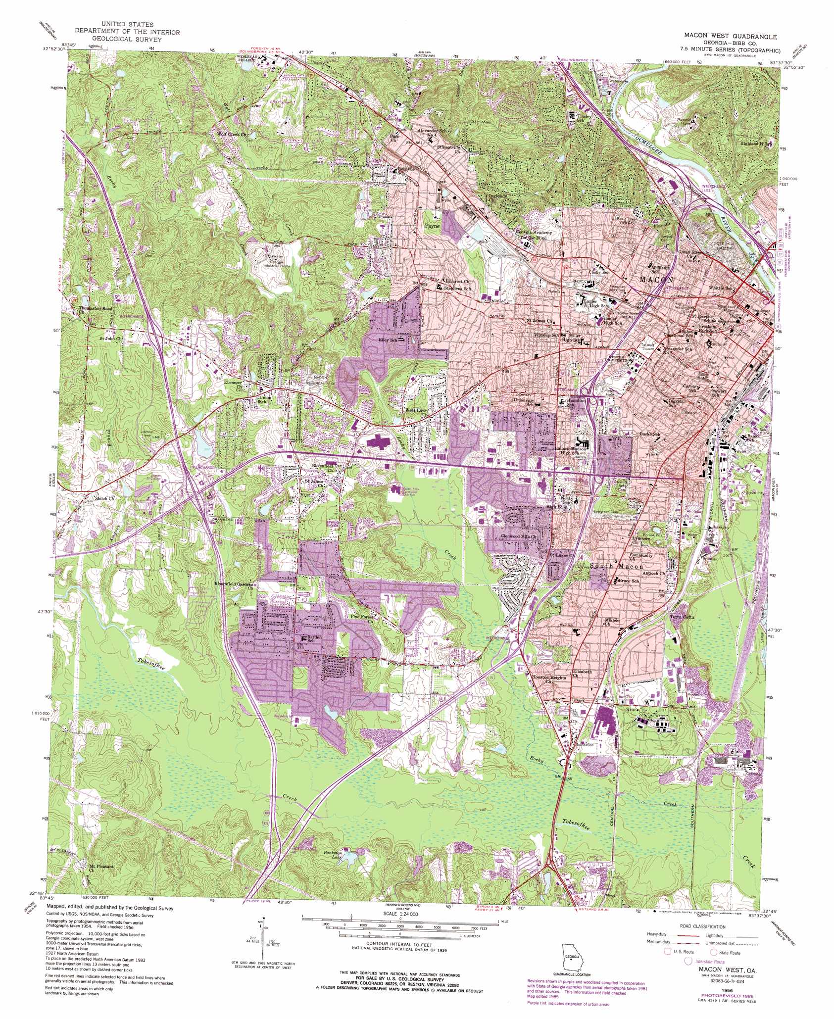
Macon West Topo Map Georgia
To zoom in, hover over the map of Macon West
USGS Topo Quad 32083g6 - 1:24,000 scale
| Topo Map Name: | Macon West |
| USGS Topo Quad ID: | 32083g6 |
| Print Size: | ca. 21 1/4" wide x 27" high |
| Southeast Coordinates: | 32.75° N latitude / 83.625° W longitude |
| Map Center Coordinates: | 32.8125° N latitude / 83.6875° W longitude |
| U.S. State: | GA |
| Filename: | o32083g6.jpg |
| Download Map JPG Image: | Macon West topo map 1:24,000 scale |
| Map Type: | Topographic |
| Topo Series: | 7.5´ |
| Map Scale: | 1:24,000 |
| Source of Map Images: | United States Geological Survey (USGS) |
| Alternate Map Versions: |
Macon West GA 1956, updated 1958 Download PDF Buy paper map Macon West GA 1956, updated 1973 Download PDF Buy paper map Macon West GA 1956, updated 1984 Download PDF Buy paper map Macon West GA 1956, updated 1986 Download PDF Buy paper map Macon West GA 2011 Download PDF Buy paper map Macon West GA 2014 Download PDF Buy paper map |
1:24,000 Topo Quads surrounding Macon West
Forsyth |
East Juliette |
Dames Ferry |
Gray |
Haddock |
Smarr |
Bolingbroke |
Macon Nw |
Macon Ne |
James |
Moran |
Lizella |
Macon West |
Macon East |
Dry Branch |
Knoxville |
Byron |
Warner Robins Nw |
Warner Robins Ne |
Marion |
Fort Valley West |
Fort Valley East |
Warner Robins Sw |
Warner Robins Se |
Tarversville |
> Back to 32083e1 at 1:100,000 scale
> Back to 32082a1 at 1:250,000 scale
> Back to U.S. Topo Maps home
Macon West topo map: Gazetteer
Macon West: Bridges
Carl Vinson Bridge elevation 86m 282′William L Stribling Bridge elevation 88m 288′
Macon West: Crossings
Exit 2 elevation 93m 305′Exit 54 elevation 101m 331′
Interchange 1 elevation 124m 406′
Interchange 1 elevation 88m 288′
Interchange 2 elevation 162m 531′
Interchange 48 elevation 122m 400′
Interchange 49 elevation 88m 288′
Interchange 50 elevation 121m 396′
Interchange 51 elevation 128m 419′
Interchange 52 elevation 128m 419′
Interchange 53 elevation 105m 344′
Macon West: Dams
Bankston Lake Dam elevation 95m 311′Kenelworth Manor Lake Dam elevation 115m 377′
Sikes Lake Dam elevation 88m 288′
Vfw Lake Dam elevation 103m 337′
Wesleyan College Lake Dam elevation 133m 436′
Macon West: Parks
Addison Tinsley Park elevation 104m 341′Anderson Park elevation 137m 449′
Ayers Park elevation 100m 328′
Bloomfield Community Park elevation 104m 341′
Dempsey Park elevation 101m 331′
Dunlap Park elevation 101m 331′
Freedom Park elevation 137m 449′
Hardeman Park elevation 108m 354′
Henderson Memorial Stadium elevation 111m 364′
Hill Park elevation 127m 416′
Hollingsworth Park elevation 99m 324′
Lamar Park elevation 102m 334′
Lanier Park elevation 131m 429′
Macon Historic District elevation 128m 419′
Macon Railroad Industrial Historic District elevation 102m 334′
Messenburg Park elevation 101m 331′
Nisbet Park elevation 100m 328′
Pleasant Hill Historic District elevation 122m 400′
Porter Field elevation 139m 456′
Prince Park elevation 101m 331′
Proudeit Park elevation 109m 357′
Rose Park elevation 135m 442′
Sparks Park elevation 115m 377′
Tattnall Square elevation 134m 439′
Turpin Park elevation 100m 328′
Vineville Historic District elevation 154m 505′
Washington Park elevation 133m 436′
Whittle Park elevation 119m 390′
Macon West: Populated Places
Anthony Terrace elevation 143m 469′Arlington Park elevation 103m 337′
Azalea Park elevation 133m 436′
Bedingfield elevation 105m 344′
Bellevue elevation 165m 541′
Bloomfield Estates elevation 115m 377′
Bloomfield Farms elevation 112m 367′
Bloomfield Gardens elevation 128m 419′
Bloomfield Heights elevation 121m 396′
Bloomfield Park elevation 132m 433′
Bon Ayer elevation 137m 449′
Briarwood elevation 112m 367′
Briarwood Hill elevation 140m 459′
Brookhaven elevation 132m 433′
Brookwood elevation 113m 370′
Brookwood Hills elevation 139m 456′
Christian Rest elevation 131m 429′
Clarkview elevation 108m 354′
Coal Neck Settlement (historical) elevation 129m 423′
College Estates elevation 125m 410′
Country Club Estates elevation 137m 449′
Crestfield elevation 121m 396′
Crestwell Heights elevation 110m 360′
Glenhaven elevation 112m 367′
Green Lawn Acres elevation 125m 410′
Green Meadows elevation 128m 419′
Greenbriar elevation 116m 380′
Groveland Park elevation 114m 374′
Highland Circle elevation 117m 383′
Hillcrest Heights elevation 131m 429′
Hillview elevation 153m 501′
Idle Hour Estates elevation 143m 469′
Idlewood elevation 136m 446′
Ingleside elevation 149m 488′
Jackson Heights elevation 103m 337′
Jarrell Heights elevation 121m 396′
Jefferson Hills elevation 98m 321′
Lakewood elevation 146m 479′
Lindsey Park elevation 106m 347′
Log Cabin Heights elevation 128m 419′
Lumberhill elevation 123m 403′
Lymore Estates elevation 115m 377′
Macon elevation 113m 370′
Meadowbrook elevation 138m 452′
Meadows elevation 98m 321′
North Forest Hills elevation 133m 436′
North Highlands elevation 129m 423′
Northwoods elevation 112m 367′
Oglethorpe Homes elevation 123m 403′
Payne elevation 157m 515′
Riverside Hills elevation 114m 374′
Sherwood Forest elevation 122m 400′
Shirley Hills elevation 124m 406′
Silver Pines elevation 99m 324′
South Highlands elevation 111m 364′
Storeyland elevation 113m 370′
Stratford Oaks elevation 141m 462′
Stratton elevation 85m 278′
Terra Cotta elevation 115m 377′
Tharpe Heights elevation 108m 354′
Unionville elevation 138m 452′
Villa Crest elevation 157m 515′
Village Green elevation 101m 331′
Vineville elevation 151m 495′
Vinson Village elevation 103m 337′
Waverly Place elevation 112m 367′
West Oak elevation 153m 501′
Westfield elevation 138m 452′
Westgate Estates elevation 115m 377′
Westminister elevation 123m 403′
Westview elevation 116m 380′
Wimbledon Woods elevation 134m 439′
Macon West: Post Offices
Macon Post Office elevation 100m 328′Macon West: Reservoirs
Bankston Lake elevation 95m 311′Kenelworth Manor Lake elevation 115m 377′
Sikes Lake elevation 88m 288′
Vfw Lake elevation 103m 337′
Wesleyan College Lake elevation 133m 436′
Macon West: Streams
Amason Branch elevation 94m 308′Bowman Branch elevation 85m 278′
Rocky Creek elevation 81m 265′
Trinity Creek elevation 108m 354′
Vineville Branch elevation 85m 278′
Wolf Creek elevation 99m 324′
Macon West digital topo map on disk
Buy this Macon West topo map showing relief, roads, GPS coordinates and other geographical features, as a high-resolution digital map file on DVD:
South Carolina, Western North Carolina & Northeastern Georgia
Buy digital topo maps: South Carolina, Western North Carolina & Northeastern Georgia