Americus Topo Map Georgia
To zoom in, hover over the map of Americus
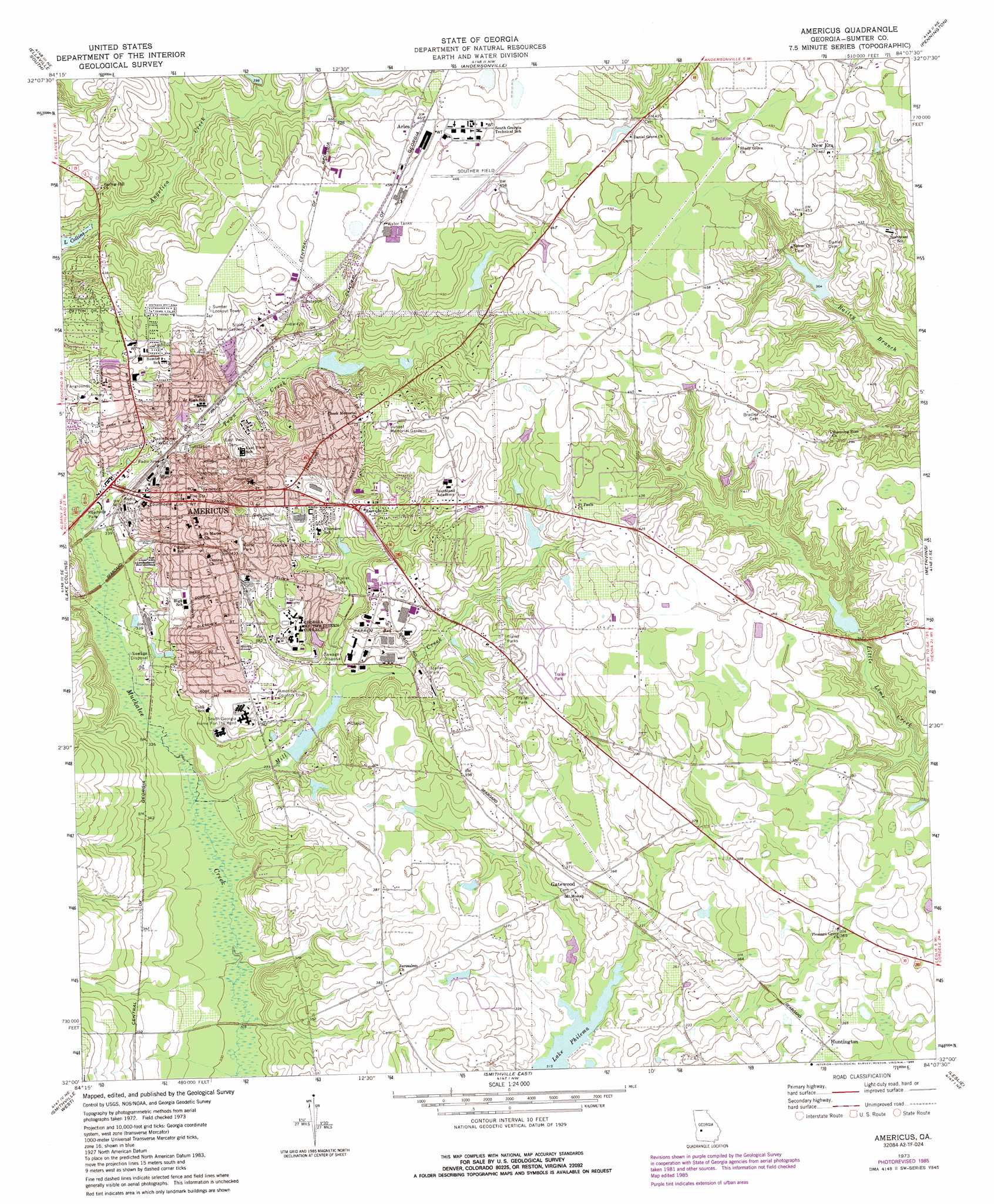
USGS Topo Quad 32084a2 - 1:24,000 scale
| Topo Map Name: | Americus |
| USGS Topo Quad ID: | 32084a2 |
| Print Size: | ca. 21 1/4" wide x 27" high |
| Southeast Coordinates: | 32° N latitude / 84.125° W longitude |
| Map Center Coordinates: | 32.0625° N latitude / 84.1875° W longitude |
| U.S. State: | GA |
| Filename: | o32084a2.jpg |
| Download Map JPG Image: | Americus topo map 1:24,000 scale |
| Map Type: | Topographic |
| Topo Series: | 7.5´ |
| Map Scale: | 1:24,000 |
| Source of Map Images: | United States Geological Survey (USGS) |
| Alternate Map Versions: |
Americus GA 1973, updated 1975 Download PDF Buy paper map Americus GA 1973, updated 1986 Download PDF Buy paper map Americus GA 2011 Download PDF Buy paper map Americus GA 2014 Download PDF Buy paper map |
1:24,000 Topo Quads surrounding Americus
Tazewell South |
Ellaville North |
Ideal South |
Montezuma |
Marshallville Sw |
Draneville |
Ellaville South |
Andersonville |
Pennington |
Byromville |
Plains |
Lake Collins |
Americus |
Methvins |
Drayton |
Bottsford |
Smithville West |
Smithville East |
Leslie |
Cobb |
Dawson |
Bronwood |
Neyami |
Leslie Se |
Warwick |
> Back to 32084a1 at 1:100,000 scale
> Back to 32084a1 at 1:250,000 scale
> Back to U.S. Topo Maps home
Americus topo map: Gazetteer
Americus: Airports
Jimmy Carter Regional Airport elevation 141m 462′Americus: Dams
Able Acres Dam elevation 106m 347′Argo Lake Dam elevation 127m 416′
Edgemon Lake Dam elevation 99m 324′
Hancock Lake Dam elevation 110m 360′
Lake Jennifer Dam elevation 99m 324′
Shipp Lake Dam elevation 104m 341′
Americus: Parks
Americus Historic District elevation 126m 413′Reese Park elevation 135m 442′
Americus: Populated Places
Americus elevation 131m 429′Arles elevation 142m 465′
Gatewood elevation 111m 364′
Huntington elevation 110m 360′
New Era elevation 141m 462′
Northside Homes elevation 134m 439′
Sumter Homes elevation 131m 429′
Americus: Post Offices
Americus Post Office elevation 125m 410′Americus: Reservoirs
Able Acres Lake elevation 106m 347′Argo Lake elevation 127m 416′
Edgemon Lake elevation 99m 324′
Hancock Lake elevation 110m 360′
Lake Jennifer elevation 99m 324′
Murphys Mill Pond elevation 102m 334′
Shipp Lake elevation 104m 341′
Americus: Streams
Angelica Creek elevation 108m 354′Mill Creek elevation 94m 308′
Town Creek elevation 96m 314′
Americus digital topo map on disk
Buy this Americus topo map showing relief, roads, GPS coordinates and other geographical features, as a high-resolution digital map file on DVD:
Gulf Coast (LA, MS, AL, FL) & Southwestern Georgia
Buy digital topo maps: Gulf Coast (LA, MS, AL, FL) & Southwestern Georgia
 & Southwestern Georgia map DVD")