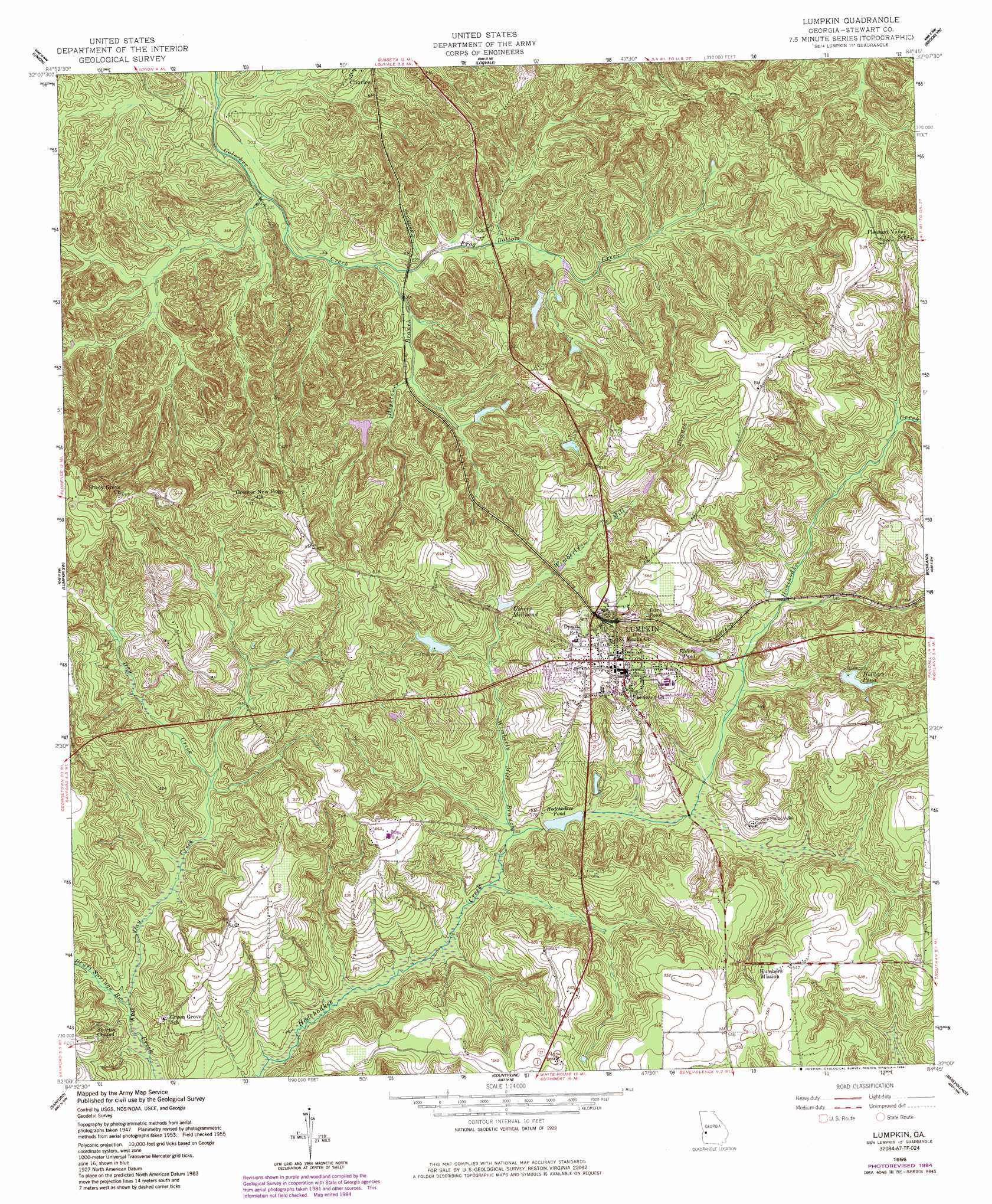
Lumpkin Topo Map Georgia
To zoom in, hover over the map of Lumpkin
USGS Topo Quad 32084a7 - 1:24,000 scale
| Topo Map Name: | Lumpkin |
| USGS Topo Quad ID: | 32084a7 |
| Print Size: | ca. 21 1/4" wide x 27" high |
| Southeast Coordinates: | 32° N latitude / 84.75° W longitude |
| Map Center Coordinates: | 32.0625° N latitude / 84.8125° W longitude |
| U.S. State: | GA |
| Filename: | o32084a7.jpg |
| Download Map JPG Image: | Lumpkin topo map 1:24,000 scale |
| Map Type: | Topographic |
| Topo Series: | 7.5´ |
| Map Scale: | 1:24,000 |
| Source of Map Images: | United States Geological Survey (USGS) |
| Alternate Map Versions: |
Lumpkin GA 1950, updated 1953 Download PDF Buy paper map Lumpkin GA 1955, updated 1959 Download PDF Buy paper map Lumpkin GA 1955, updated 1984 Download PDF Buy paper map Lumpkin GA 2011 Download PDF Buy paper map Lumpkin GA 2014 Download PDF Buy paper map |
1:24,000 Topo Quads surrounding Lumpkin
Fort Mitchell |
Fort Benning |
Cusseta |
Glen Alta |
Buena Vista |
Omaha |
Union |
Louvale |
Brooklyn |
Church Hill |
Twin Springs |
Lumpkin Sw |
Lumpkin |
Richland |
Preston |
Georgetown |
Sanford |
County Line |
Benevolence |
Parrott |
Hatcher |
Morris |
Cuthbert |
Brooksville |
Shellman |
> Back to 32084a1 at 1:100,000 scale
> Back to 32084a1 at 1:250,000 scale
> Back to U.S. Topo Maps home
Lumpkin topo map: Gazetteer
Lumpkin: Bridges
Vorus Bridge (historical) elevation 109m 357′Lumpkin: Dams
Forts Pond Dam elevation 131m 429′Hodchodkee Pond Dam elevation 115m 377′
Holders Pond Dam elevation 135m 442′
Ushers Millpond Dam elevation 126m 413′
Lumpkin: Parks
East Main Street Residential Historic District elevation 177m 580′Lumpkin Commercial Historic District elevation 179m 587′
Pigtail Alley Historic District elevation 175m 574′
Uptown Residential Historic District elevation 178m 583′
Lumpkin: Populated Places
Lumpkin elevation 180m 590′Westville elevation 142m 465′
Lumpkin: Reservoirs
Davis Pond elevation 147m 482′Elders Pond elevation 132m 433′
Forts Pond elevation 131m 429′
Hodchodkee Pond elevation 110m 360′
Holders Pond elevation 135m 442′
Ushers Millpond elevation 126m 413′
Lumpkin: Streams
Ball Branch elevation 106m 347′Bluff Springs Branch elevation 103m 337′
Frog Bottom Creek elevation 94m 308′
Hightower Branch elevation 94m 308′
West Branch elevation 116m 380′
Wimberly Mill Branch elevation 107m 351′
Lumpkin: Valleys
Peek Hollow elevation 125m 410′Lumpkin digital topo map on disk
Buy this Lumpkin topo map showing relief, roads, GPS coordinates and other geographical features, as a high-resolution digital map file on DVD:
Gulf Coast (LA, MS, AL, FL) & Southwestern Georgia
Buy digital topo maps: Gulf Coast (LA, MS, AL, FL) & Southwestern Georgia
 & Southwestern Georgia map DVD")