Lumpkin Sw Topo Map Georgia
To zoom in, hover over the map of Lumpkin Sw
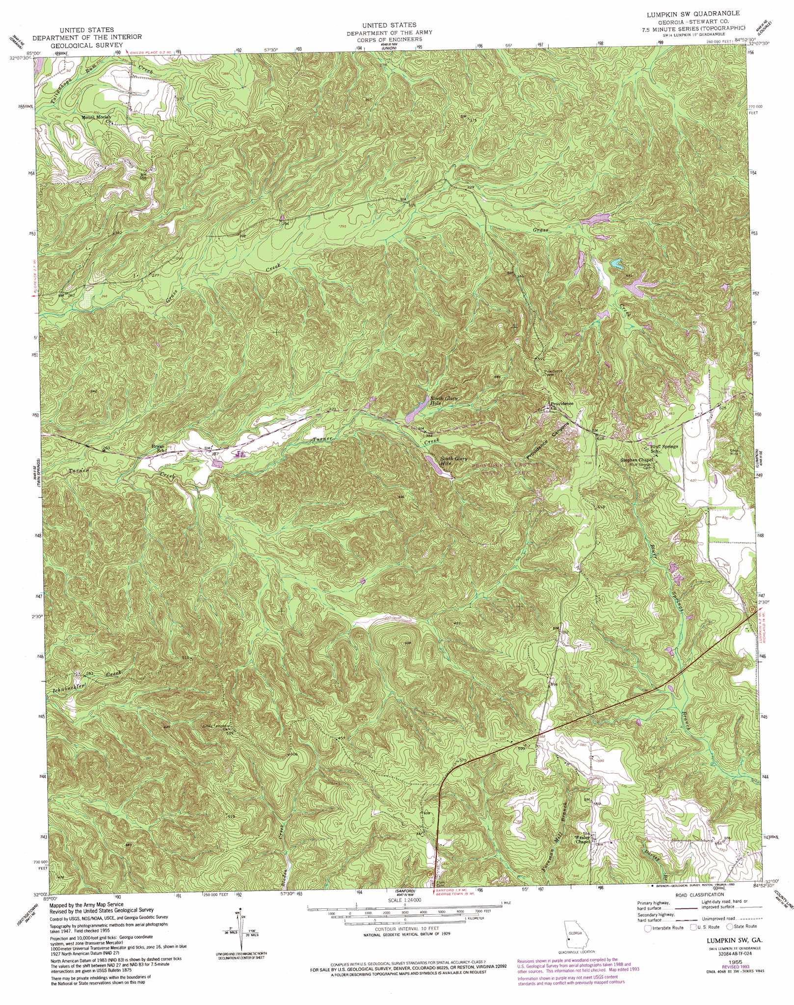
USGS Topo Quad 32084a8 - 1:24,000 scale
| Topo Map Name: | Lumpkin Sw |
| USGS Topo Quad ID: | 32084a8 |
| Print Size: | ca. 21 1/4" wide x 27" high |
| Southeast Coordinates: | 32° N latitude / 84.875° W longitude |
| Map Center Coordinates: | 32.0625° N latitude / 84.9375° W longitude |
| U.S. State: | GA |
| Filename: | o32084a8.jpg |
| Download Map JPG Image: | Lumpkin Sw topo map 1:24,000 scale |
| Map Type: | Topographic |
| Topo Series: | 7.5´ |
| Map Scale: | 1:24,000 |
| Source of Map Images: | United States Geological Survey (USGS) |
| Alternate Map Versions: |
Lumpkin SW GA 1950, updated 1953 Download PDF Buy paper map Lumpkin SW GA 1955, updated 1959 Download PDF Buy paper map Lumpkin SW GA 1955, updated 1993 Download PDF Buy paper map Lumpkin SW GA 2011 Download PDF Buy paper map Lumpkin SW GA 2014 Download PDF Buy paper map |
1:24,000 Topo Quads surrounding Lumpkin Sw
Seale |
Fort Mitchell |
Fort Benning |
Cusseta |
Glen Alta |
Pittsview |
Omaha |
Union |
Louvale |
Brooklyn |
Howe |
Twin Springs |
Lumpkin Sw |
Lumpkin |
Richland |
Eufaula North |
Georgetown |
Sanford |
County Line |
Benevolence |
Eufaula South |
Hatcher |
Morris |
Cuthbert |
Brooksville |
> Back to 32084a1 at 1:100,000 scale
> Back to 32084a1 at 1:250,000 scale
> Back to U.S. Topo Maps home
Lumpkin Sw topo map: Gazetteer
Lumpkin Sw: Bays
North Glory Hole elevation 100m 328′South Glory Hole elevation 109m 357′
Lumpkin Sw: Dams
Taylor Lake Dam elevation 89m 291′Lumpkin Sw: Parks
Providence Canyon State Park elevation 117m 383′Lumpkin Sw: Populated Places
Beatrice elevation 170m 557′Lumpkin Sw: Ranges
Patterson Hills elevation 173m 567′Lumpkin Sw: Reservoirs
Taylor Lake elevation 89m 291′Lumpkin Sw: Streams
Soapstone Creek elevation 75m 246′Lumpkin Sw: Valleys
Providence Canyons elevation 124m 406′Lumpkin Sw: Woods
California Woods elevation 77m 252′Lumpkin Sw digital topo map on disk
Buy this Lumpkin Sw topo map showing relief, roads, GPS coordinates and other geographical features, as a high-resolution digital map file on DVD:
Gulf Coast (LA, MS, AL, FL) & Southwestern Georgia
Buy digital topo maps: Gulf Coast (LA, MS, AL, FL) & Southwestern Georgia
 & Southwestern Georgia map DVD")