Louvale Topo Map Georgia
To zoom in, hover over the map of Louvale
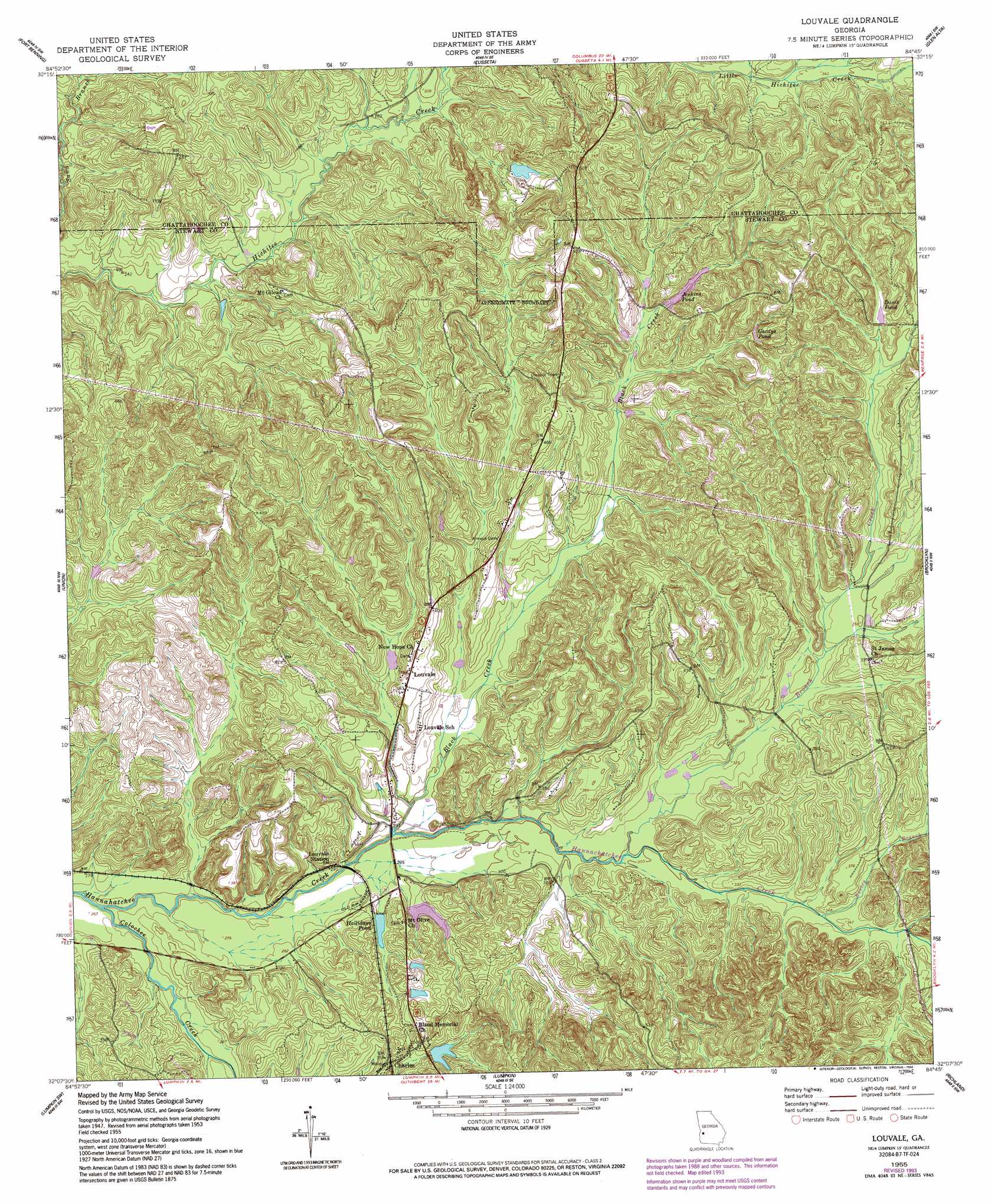
USGS Topo Quad 32084b7 - 1:24,000 scale
| Topo Map Name: | Louvale |
| USGS Topo Quad ID: | 32084b7 |
| Print Size: | ca. 21 1/4" wide x 27" high |
| Southeast Coordinates: | 32.125° N latitude / 84.75° W longitude |
| Map Center Coordinates: | 32.1875° N latitude / 84.8125° W longitude |
| U.S. State: | GA |
| Filename: | o32084b7.jpg |
| Download Map JPG Image: | Louvale topo map 1:24,000 scale |
| Map Type: | Topographic |
| Topo Series: | 7.5´ |
| Map Scale: | 1:24,000 |
| Source of Map Images: | United States Geological Survey (USGS) |
| Alternate Map Versions: |
Louvale GA 1950, updated 1953 Download PDF Buy paper map Louvale GA 1955, updated 1959 Download PDF Buy paper map Louvale GA 1955, updated 1991 Download PDF Buy paper map Louvale GA 1955, updated 1994 Download PDF Buy paper map Louvale GA 2011 Download PDF Buy paper map Louvale GA 2014 Download PDF Buy paper map |
1:24,000 Topo Quads surrounding Louvale
Phenix City |
Columbus |
Ochillee |
Buena Vista Nw |
Buena Vista Ne |
Fort Mitchell |
Fort Benning |
Cusseta |
Glen Alta |
Buena Vista |
Omaha |
Union |
Louvale |
Brooklyn |
Church Hill |
Twin Springs |
Lumpkin Sw |
Lumpkin |
Richland |
Preston |
Georgetown |
Sanford |
County Line |
Benevolence |
Parrott |
> Back to 32084a1 at 1:100,000 scale
> Back to 32084a1 at 1:250,000 scale
> Back to U.S. Topo Maps home
Louvale topo map: Gazetteer
Louvale: Dams
Davis Pond Dam elevation 122m 400′Dykes Pond Dam elevation 104m 341′
Halliday Lake Dam elevation 92m 301′
Hallidays Pond Dam elevation 90m 295′
Jenkins Pond Dam elevation 120m 393′
Williamson Pond Dam elevation 106m 347′
Louvale: Parks
Hannahatchee Wildlife Management Area elevation 106m 347′Louvale Church Row Historic District elevation 122m 400′
Louvale: Populated Places
Charles elevation 107m 351′Green Hill (historical) elevation 160m 524′
Louvale elevation 117m 383′
Louvale Station elevation 91m 298′
Louvale: Post Offices
Louvale Post Office elevation 118m 387′Louvale: Reservoirs
Davis Pond elevation 122m 400′Dykes Pond elevation 104m 341′
Gordys Pond elevation 133m 436′
Halliday Lake elevation 92m 301′
Hallidays Pond elevation 90m 295′
Jenkins Pond elevation 120m 393′
Williamsons Pond elevation 106m 347′
Louvale: Streams
Black Creek elevation 85m 278′Broach Creek elevation 90m 295′
Bussey Branch elevation 98m 321′
Cany Creek elevation 83m 272′
Colochee Creek elevation 79m 259′
Louvale digital topo map on disk
Buy this Louvale topo map showing relief, roads, GPS coordinates and other geographical features, as a high-resolution digital map file on DVD:
Gulf Coast (LA, MS, AL, FL) & Southwestern Georgia
Buy digital topo maps: Gulf Coast (LA, MS, AL, FL) & Southwestern Georgia
 & Southwestern Georgia map DVD")