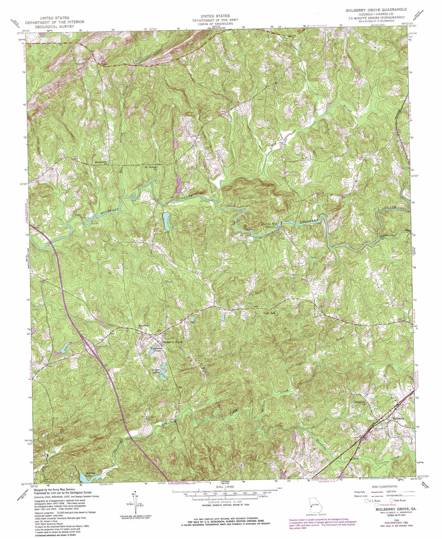
Mulberry Grove Topo Map Georgia
To zoom in, hover over the map of Mulberry Grove
USGS Topo Quad 32084f8 - 1:24,000 scale
| Topo Map Name: | Mulberry Grove |
| USGS Topo Quad ID: | 32084f8 |
| Print Size: | ca. 21 1/4" wide x 27" high |
| Southeast Coordinates: | 32.625° N latitude / 84.875° W longitude |
| Map Center Coordinates: | 32.6875° N latitude / 84.9375° W longitude |
| U.S. State: | GA |
| Filename: | o32084f8.jpg |
| Download Map JPG Image: | Mulberry Grove topo map 1:24,000 scale |
| Map Type: | Topographic |
| Topo Series: | 7.5´ |
| Map Scale: | 1:24,000 |
| Source of Map Images: | United States Geological Survey (USGS) |
| Alternate Map Versions: |
Mulberry Grove GA 1950, updated 1953 Download PDF Buy paper map Mulberry Grove GA 1955, updated 1959 Download PDF Buy paper map Mulberry Grove GA 1955, updated 1979 Download PDF Buy paper map Mulberry Grove GA 1955, updated 1986 Download PDF Buy paper map Mulberry Grove GA 2011 Download PDF Buy paper map Mulberry Grove GA 2014 Download PDF Buy paper map |
1:24,000 Topo Quads surrounding Mulberry Grove
Lanett North |
Cannonville |
Hilyer |
Durand |
Warm Springs |
Lanett South |
Whitesville |
Pine Mountain Sw |
Pine Mountain |
Shiloh |
Beulah |
Bartletts Ferry Dam |
Mulberry Grove |
Cataula |
Waverly Hall |
Bleecker |
Smiths Station |
Fortson |
Midland |
Upatoi |
Crawford |
Phenix City |
Columbus |
Ochillee |
Buena Vista Nw |
> Back to 32084e1 at 1:100,000 scale
> Back to 32084a1 at 1:250,000 scale
> Back to U.S. Topo Maps home
Mulberry Grove topo map: Gazetteer
Mulberry Grove: Crossings
Interchange 10 elevation 204m 669′Mulberry Grove: Dams
Bickerstaff Lake Dam elevation 163m 534′Bickerstaff Lake South Dam elevation 163m 534′
Casselberry Lake Dam elevation 181m 593′
Herds Lake Dam elevation 207m 679′
Lower Casselberry Lake Dam elevation 176m 577′
Nelson Dam elevation 173m 567′
Mulberry Grove: Lakes
Lake Asa elevation 183m 600′Mobleys Lake elevation 136m 446′
Mulberry Grove: Parks
Linwood Playground elevation 141m 462′Mulberry Grove: Populated Places
Bayard (historical) elevation 198m 649′Mulberry Grove elevation 195m 639′
Rehobeth elevation 199m 652′
Mulberry Grove: Rapids
Hudson Mill Rapids elevation 165m 541′Mulberry Grove: Reservoirs
Bickerstaff Lake elevation 163m 534′Bickerstaff Lake South elevation 163m 534′
Casselberry Lake elevation 181m 593′
Herds Lake elevation 207m 679′
James Lakes elevation 168m 551′
Lower Casselberry Lake elevation 176m 577′
Nelson Lake elevation 173m 567′
Mulberry Grove: Springs
Blue Spring elevation 215m 705′Mulberry Grove: Streams
Barnes Creek elevation 171m 561′Blue Spring Branch elevation 155m 508′
Little Branch elevation 159m 521′
Ossahatchie Creek elevation 170m 557′
Striblin Creek elevation 148m 485′
Mulberry Grove digital topo map on disk
Buy this Mulberry Grove topo map showing relief, roads, GPS coordinates and other geographical features, as a high-resolution digital map file on DVD:
Gulf Coast (LA, MS, AL, FL) & Southwestern Georgia
Buy digital topo maps: Gulf Coast (LA, MS, AL, FL) & Southwestern Georgia
 & Southwestern Georgia map DVD")