Culloden Topo Map Georgia
To zoom in, hover over the map of Culloden
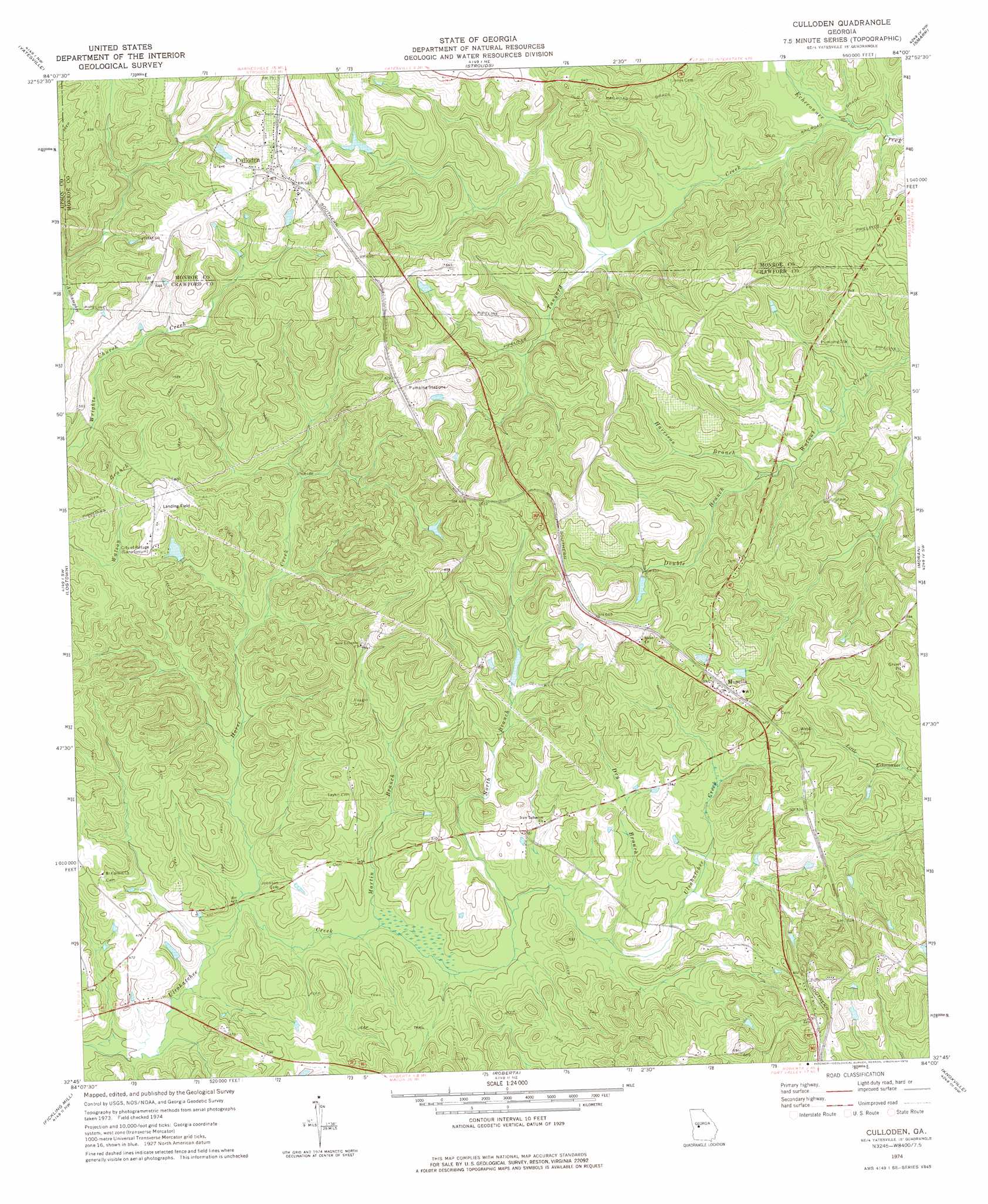
USGS Topo Quad 32084g1 - 1:24,000 scale
| Topo Map Name: | Culloden |
| USGS Topo Quad ID: | 32084g1 |
| Print Size: | ca. 21 1/4" wide x 27" high |
| Southeast Coordinates: | 32.75° N latitude / 84° W longitude |
| Map Center Coordinates: | 32.8125° N latitude / 84.0625° W longitude |
| U.S. State: | GA |
| Filename: | o32084g1.jpg |
| Download Map JPG Image: | Culloden topo map 1:24,000 scale |
| Map Type: | Topographic |
| Topo Series: | 7.5´ |
| Map Scale: | 1:24,000 |
| Source of Map Images: | United States Geological Survey (USGS) |
| Alternate Map Versions: |
Culloden GA 1974, updated 1976 Download PDF Buy paper map Culloden GA 2011 Download PDF Buy paper map Culloden GA 2014 Download PDF Buy paper map |
1:24,000 Topo Quads surrounding Culloden
Zebulon |
Barnesville |
Johnstonville |
Forsyth |
East Juliette |
Thomaston |
Yatesville |
Strouds |
Smarr |
Bolingbroke |
Lincoln Park |
Logtown |
Culloden |
Moran |
Lizella |
Prattsburg |
Fickling Mill |
Roberta |
Knoxville |
Byron |
Butler West |
Butler East |
Reynolds |
Fort Valley West |
Fort Valley East |
> Back to 32084e1 at 1:100,000 scale
> Back to 32084a1 at 1:250,000 scale
> Back to U.S. Topo Maps home
Culloden topo map: Gazetteer
Culloden: Dams
Fincher Lake Dam elevation 194m 636′Haygood Pond Dam elevation 183m 600′
Roloff Corporation Dam elevation 157m 515′
Culloden: Parks
Culloden Historic District elevation 211m 692′Culloden: Populated Places
Culloden elevation 211m 692′Musella elevation 180m 590′
Culloden: Post Offices
Culloden Post Office elevation 215m 705′Musella Post Office elevation 181m 593′
Culloden: Reservoirs
Fincher Lake elevation 194m 636′Haygood Pond elevation 183m 600′
Roloff Corporation Lake elevation 157m 515′
Culloden: Streams
Double Branch elevation 151m 495′Dry Branch elevation 140m 459′
Harrison Branch elevation 151m 495′
Horse Creek elevation 125m 410′
Martin Branch elevation 130m 426′
North Branch Ulcohatchee Creek elevation 136m 446′
Tanyard Creek elevation 136m 446′
Culloden digital topo map on disk
Buy this Culloden topo map showing relief, roads, GPS coordinates and other geographical features, as a high-resolution digital map file on DVD:
Gulf Coast (LA, MS, AL, FL) & Southwestern Georgia
Buy digital topo maps: Gulf Coast (LA, MS, AL, FL) & Southwestern Georgia
 & Southwestern Georgia map DVD")