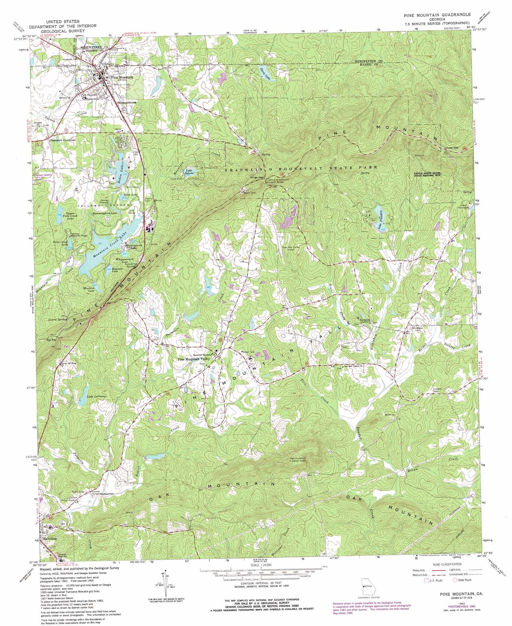
Pine Mountain Topo Map Georgia
To zoom in, hover over the map of Pine Mountain
USGS Topo Quad 32084g7 - 1:24,000 scale
| Topo Map Name: | Pine Mountain |
| USGS Topo Quad ID: | 32084g7 |
| Print Size: | ca. 21 1/4" wide x 27" high |
| Southeast Coordinates: | 32.75° N latitude / 84.75° W longitude |
| Map Center Coordinates: | 32.8125° N latitude / 84.8125° W longitude |
| U.S. State: | GA |
| Filename: | o32084g7.jpg |
| Download Map JPG Image: | Pine Mountain topo map 1:24,000 scale |
| Map Type: | Topographic |
| Topo Series: | 7.5´ |
| Map Scale: | 1:24,000 |
| Source of Map Images: | United States Geological Survey (USGS) |
| Alternate Map Versions: |
Pine Mountain GA 1964, updated 1966 Download PDF Buy paper map Pine Mountain GA 2011 Download PDF Buy paper map Pine Mountain GA 2014 Download PDF Buy paper map |
1:24,000 Topo Quads surrounding Pine Mountain
La Grange |
Mountville |
Odessadale |
Greenville |
Gay |
Cannonville |
Hilyer |
Durand |
Warm Springs |
Woodbury |
Whitesville |
Pine Mountain Sw |
Pine Mountain |
Shiloh |
Manchester |
Bartletts Ferry Dam |
Mulberry Grove |
Cataula |
Waverly Hall |
Talbotton |
Smiths Station |
Fortson |
Midland |
Upatoi |
Geneva |
> Back to 32084e1 at 1:100,000 scale
> Back to 32084a1 at 1:250,000 scale
> Back to U.S. Topo Maps home
Pine Mountain topo map: Gazetteer
Pine Mountain: Areas
Callaway Gardens elevation 256m 839′Pine Mountain: Basins
Pine Mountain Valley elevation 252m 826′Pine Mountain: Bridges
Franklin D Roosevelt Memorial Bridge elevation 360m 1181′Pine Mountain: Dams
Davis Lake Dam elevation 266m 872′Delano Lake Dam elevation 269m 882′
Horton Dam elevation 262m 859′
Lake Franklin Dam elevation 251m 823′
Mountain Creek Lake Dam elevation 235m 770′
Palmetto Creek Structure Number 10 Dam elevation 219m 718′
Palmetto Creek Structure Number One Dam elevation 216m 708′
Palmetto Creek Strucutre Number Six Dam elevation 249m 816′
Parker Lake Dam elevation 255m 836′
Phillips Dam elevation 262m 859′
Robin Lake Dam elevation 259m 849′
Upper Falls Creek Lake Dam elevation 256m 839′
Whippoorwill Lake Dam elevation 253m 830′
White Lake Dam elevation 253m 830′
Wren Lake Dam elevation 253m 830′
Pine Mountain: Gaps
Hines Gap elevation 377m 1236′Hog Gap elevation 315m 1033′
Kings Gap elevation 360m 1181′
Pine Mountain: Lakes
Falls Creek Lake elevation 234m 767′Hummingbird Lake elevation 253m 830′
Lake Lorraine elevation 216m 708′
Mockingbrid Lake elevation 252m 826′
Pine Mountain: Parks
Franklin D Roosevelt State Park elevation 401m 1315′Pine Mountain: Populated Places
Champion Crossroad elevation 267m 875′Hamilton elevation 234m 767′
Mountainbrook elevation 282m 925′
Pine Mountain elevation 279m 915′
Pine Mountain Valley elevation 267m 875′
Pine Mountain: Reservoirs
Bluebird Lake elevation 252m 826′Bobolink Lake elevation 254m 833′
Davis Lake elevation 266m 872′
Delano Lake Dam elevation 281m 921′
Gallops Lakes elevation 248m 813′
Horton Lake elevation 262m 859′
Lake Delano elevation 269m 882′
Lake Franklin elevation 251m 823′
Mountain Creek Lake elevation 235m 770′
Palmetto Creek Structure Number 10 La elevation 219m 718′
Palmetto Creek Structure Number One Lak elevation 216m 708′
Palmetto Creek Structure Number Six Lak elevation 249m 816′
Parker Lake elevation 255m 836′
Phillips Lake elevation 262m 859′
Robin Lake elevation 259m 849′
Upper Falls Creek Lake elevation 256m 839′
Whippoorwill Lake elevation 253m 830′
White Lake elevation 253m 830′
Wren Lake elevation 249m 816′
Pine Mountain: Springs
Kings Gap Spring elevation 318m 1043′Laurel Springs elevation 273m 895′
Pine Mountain: Streams
Beaver Creek elevation 200m 656′Bethel Creek elevation 219m 718′
Bethlehem Creek elevation 219m 718′
Brown Creek elevation 212m 695′
Fort Creek elevation 216m 708′
Grant Creek elevation 224m 734′
Stanley Creek elevation 225m 738′
Pine Mountain: Summits
Oak Mountain elevation 372m 1220′Tip Top elevation 347m 1138′
Pine Mountain digital topo map on disk
Buy this Pine Mountain topo map showing relief, roads, GPS coordinates and other geographical features, as a high-resolution digital map file on DVD:
Gulf Coast (LA, MS, AL, FL) & Southwestern Georgia
Buy digital topo maps: Gulf Coast (LA, MS, AL, FL) & Southwestern Georgia
 & Southwestern Georgia map DVD")