Pine Mountain Sw Topo Map Georgia
To zoom in, hover over the map of Pine Mountain Sw
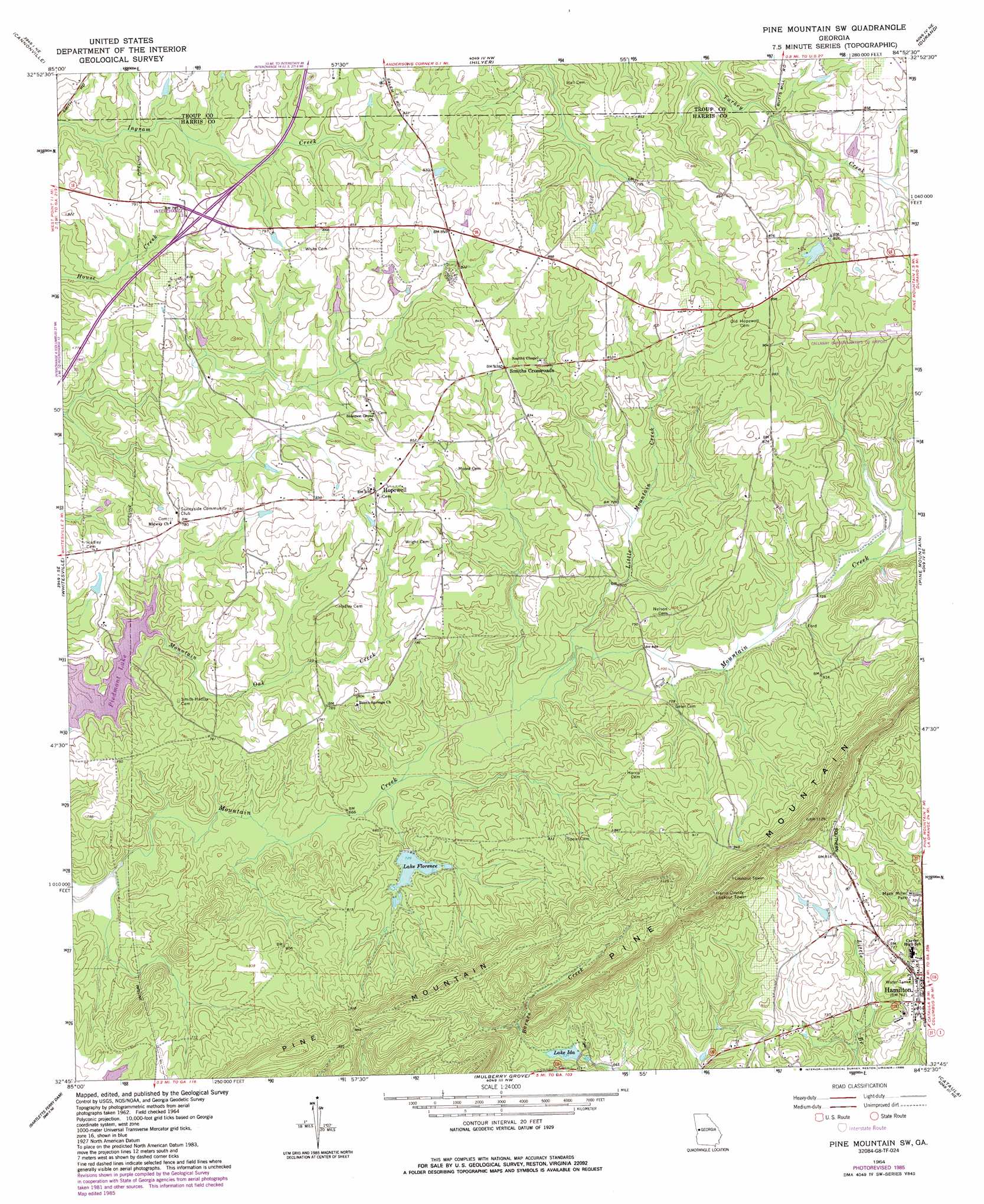
USGS Topo Quad 32084g8 - 1:24,000 scale
| Topo Map Name: | Pine Mountain Sw |
| USGS Topo Quad ID: | 32084g8 |
| Print Size: | ca. 21 1/4" wide x 27" high |
| Southeast Coordinates: | 32.75° N latitude / 84.875° W longitude |
| Map Center Coordinates: | 32.8125° N latitude / 84.9375° W longitude |
| U.S. State: | GA |
| Filename: | o32084g8.jpg |
| Download Map JPG Image: | Pine Mountain Sw topo map 1:24,000 scale |
| Map Type: | Topographic |
| Topo Series: | 7.5´ |
| Map Scale: | 1:24,000 |
| Source of Map Images: | United States Geological Survey (USGS) |
| Alternate Map Versions: |
Pine Mountain SW GA 1964, updated 1966 Download PDF Buy paper map Pine Mountain SW GA 1964, updated 1986 Download PDF Buy paper map Pine Mountain SW GA 2011 Download PDF Buy paper map Pine Mountain SW GA 2014 Download PDF Buy paper map |
1:24,000 Topo Quads surrounding Pine Mountain Sw
Abbottsford |
La Grange |
Mountville |
Odessadale |
Greenville |
Lanett North |
Cannonville |
Hilyer |
Durand |
Warm Springs |
Lanett South |
Whitesville |
Pine Mountain Sw |
Pine Mountain |
Shiloh |
Beulah |
Bartletts Ferry Dam |
Mulberry Grove |
Cataula |
Waverly Hall |
Bleecker |
Smiths Station |
Fortson |
Midland |
Upatoi |
> Back to 32084e1 at 1:100,000 scale
> Back to 32084a1 at 1:250,000 scale
> Back to U.S. Topo Maps home
Pine Mountain Sw topo map: Gazetteer
Pine Mountain Sw: Airports
Callaway Gardens-Harris County Airport elevation 270m 885′Pine Mountain Sw: Dams
Foundation Lake Dam elevation 257m 843′Lake Florence Dam elevation 218m 715′
Lake Ida Dam elevation 222m 728′
Pine Mountain Chalet Lake Dam elevation 259m 849′
Tabernacle Camp Lake Dam elevation 268m 879′
Pine Mountain Sw: Lakes
Lake Florence elevation 218m 715′Pine Mountain Sw: Parks
Mack Miller Park elevation 224m 734′Pine Mountain Sw: Populated Places
Beech Springs elevation 244m 800′Copeland (historical) elevation 240m 787′
Hopewell elevation 256m 839′
Smiths Crossroads elevation 256m 839′
Wisdoms Store (historical) elevation 250m 820′
Pine Mountain Sw: Reservoirs
Foundation Lake elevation 257m 843′Lake Florence elevation 222m 728′
Lake Ida elevation 222m 728′
Pine Mountain Chalet Lake elevation 259m 849′
Tabernacle Camp Lake elevation 268m 879′
Pine Mountain Sw: Streams
Little Mountain Creek elevation 205m 672′Pine Mountain Sw digital topo map on disk
Buy this Pine Mountain Sw topo map showing relief, roads, GPS coordinates and other geographical features, as a high-resolution digital map file on DVD:
Gulf Coast (LA, MS, AL, FL) & Southwestern Georgia
Buy digital topo maps: Gulf Coast (LA, MS, AL, FL) & Southwestern Georgia
 & Southwestern Georgia map DVD")