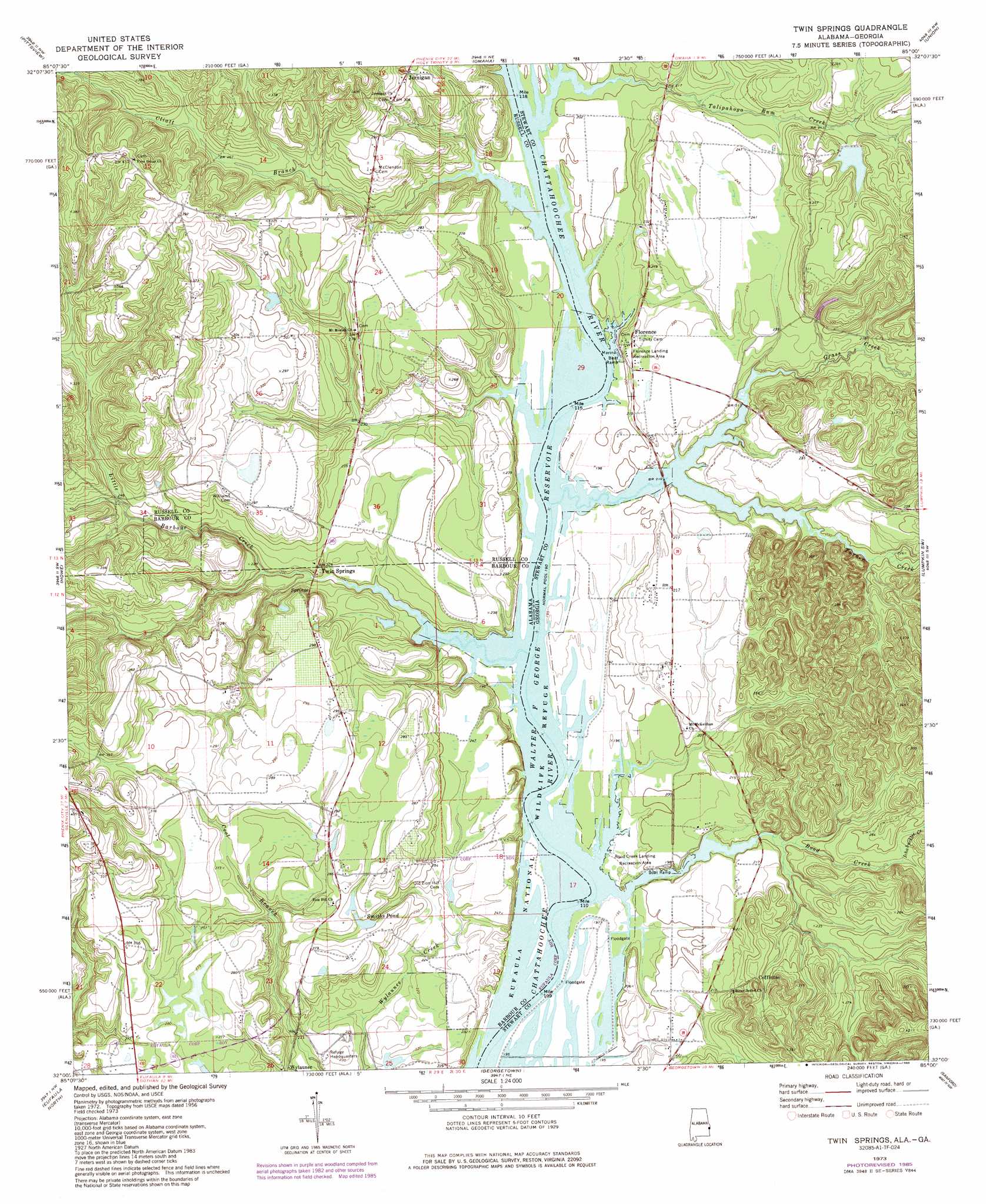
Twin Springs Topo Map Alabama
To zoom in, hover over the map of Twin Springs
USGS Topo Quad 32085a1 - 1:24,000 scale
| Topo Map Name: | Twin Springs |
| USGS Topo Quad ID: | 32085a1 |
| Print Size: | ca. 21 1/4" wide x 27" high |
| Southeast Coordinates: | 32° N latitude / 85° W longitude |
| Map Center Coordinates: | 32.0625° N latitude / 85.0625° W longitude |
| U.S. States: | AL, GA |
| Filename: | o32085a1.jpg |
| Download Map JPG Image: | Twin Springs topo map 1:24,000 scale |
| Map Type: | Topographic |
| Topo Series: | 7.5´ |
| Map Scale: | 1:24,000 |
| Source of Map Images: | United States Geological Survey (USGS) |
| Alternate Map Versions: |
Twin Springs AL 1973, updated 1976 Download PDF Buy paper map Twin Springs AL 1973, updated 1985 Download PDF Buy paper map Twin Springs AL 2011 Download PDF Buy paper map Twin Springs AL 2011 Download PDF Buy paper map Twin Springs AL 2014 Download PDF Buy paper map |
1:24,000 Topo Quads surrounding Twin Springs
Hatchechubbee |
Seale |
Fort Mitchell |
Fort Benning |
Cusseta |
Rutherford |
Pittsview |
Omaha |
Union |
Louvale |
Batesville |
Howe |
Twin Springs |
Lumpkin Sw |
Lumpkin |
White Oak |
Eufaula North |
Georgetown |
Sanford |
County Line |
Baker Hill |
Eufaula South |
Hatcher |
Morris |
Cuthbert |
> Back to 32085a1 at 1:100,000 scale
> Back to 32084a1 at 1:250,000 scale
> Back to U.S. Topo Maps home
Twin Springs topo map: Gazetteer
Twin Springs: Dams
Bradley Lake Dam elevation 84m 275′Twin Springs: Parks
Florence Landing Recreation Area elevation 67m 219′Florence Marina State Park elevation 60m 196′
Rood Creek Landing Recreation Area elevation 60m 196′
Sheppard Plantation Battle Monument elevation 70m 229′
Twin Springs: Populated Places
Cedar (historical) elevation 92m 301′Coffinton elevation 85m 278′
Florence elevation 67m 219′
Roanoke (historical) elevation 58m 190′
Twin Springs: Post Offices
Cliatts Post Office (historical) elevation 82m 269′Twin Springs: Reservoirs
Bradley Lake elevation 84m 275′Smiths Pond elevation 78m 255′
Twin Springs: Streams
Cliatt Branch elevation 58m 190′Grass Creek elevation 60m 196′
Ichabuckler Creek elevation 69m 226′
Little Barbour Creek elevation 58m 190′
Mathias Branch elevation 59m 193′
Rood Creek elevation 59m 193′
Talipahoga Rum Creek elevation 58m 190′
Turner Creek elevation 58m 190′
Twin Springs digital topo map on disk
Buy this Twin Springs topo map showing relief, roads, GPS coordinates and other geographical features, as a high-resolution digital map file on DVD:
Gulf Coast (LA, MS, AL, FL) & Southwestern Georgia
Buy digital topo maps: Gulf Coast (LA, MS, AL, FL) & Southwestern Georgia
 & Southwestern Georgia map DVD")