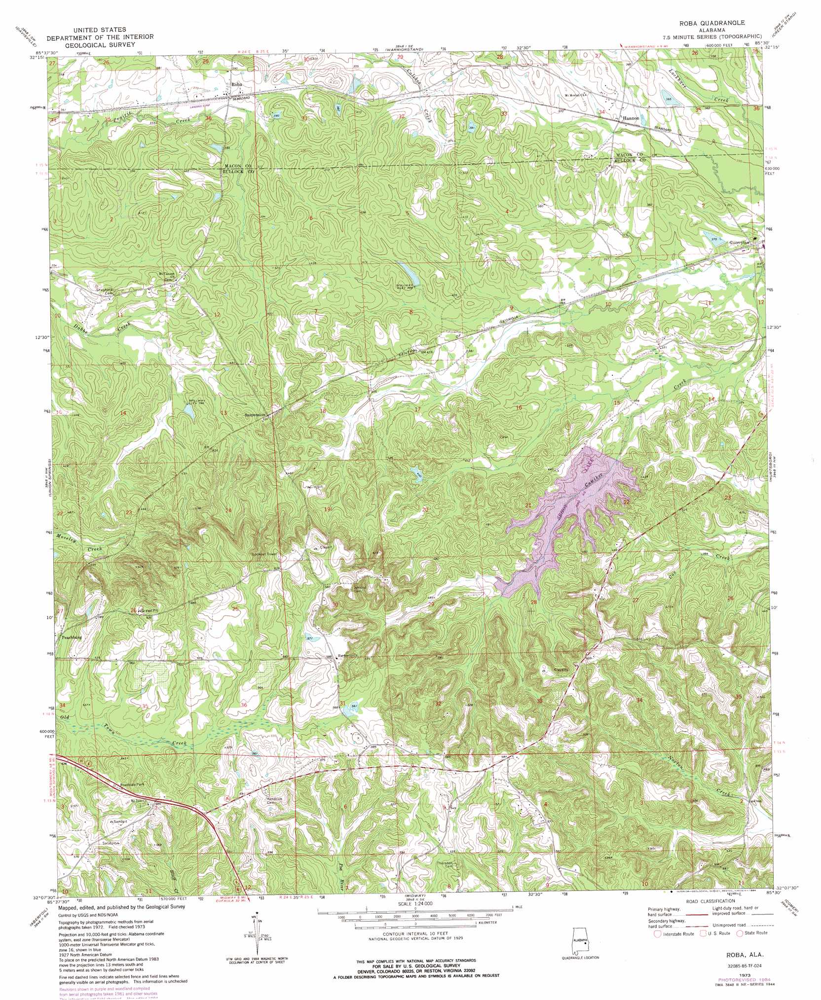
Roba Topo Map Alabama
To zoom in, hover over the map of Roba
USGS Topo Quad 32085b5 - 1:24,000 scale
| Topo Map Name: | Roba |
| USGS Topo Quad ID: | 32085b5 |
| Print Size: | ca. 21 1/4" wide x 27" high |
| Southeast Coordinates: | 32.125° N latitude / 85.5° W longitude |
| Map Center Coordinates: | 32.1875° N latitude / 85.5625° W longitude |
| U.S. State: | AL |
| Filename: | o32085b5.jpg |
| Download Map JPG Image: | Roba topo map 1:24,000 scale |
| Map Type: | Topographic |
| Topo Series: | 7.5´ |
| Map Scale: | 1:24,000 |
| Source of Map Images: | United States Geological Survey (USGS) |
| Alternate Map Versions: |
Roba AL 1973, updated 1976 Download PDF Buy paper map Roba AL 1973, updated 1984 Download PDF Buy paper map Roba AL 2011 Download PDF Buy paper map Roba AL 2014 Download PDF Buy paper map |
1:24,000 Topo Quads surrounding Roba
La Place |
Tuskegee |
Little Texas |
Society Hill |
Marvyn |
Hardaway |
Davisville |
Warriorstand |
Creek Stand |
Hatchechubbee |
Thompson |
Union Springs |
Roba |
Hurtsboro |
Rutherford |
Almeria |
Aberfoil |
Midway |
Comer |
Batesville |
Saco |
Perote |
Mount Andrew |
Clayton North |
White Oak |
> Back to 32085a1 at 1:100,000 scale
> Back to 32084a1 at 1:250,000 scale
> Back to U.S. Topo Maps home
Roba topo map: Gazetteer
Roba: Airports
Spratling Field elevation 110m 360′Roba: Dams
Mcclean Lake Dam elevation 124m 406′Sehoy Dam elevation 114m 374′
Sehoy Plantation Lake Dam elevation 115m 377′
Roba: Populated Places
Guerryton elevation 109m 357′Hannon elevation 109m 357′
Peachburg elevation 161m 528′
Roba elevation 113m 370′
Suspension elevation 127m 416′
Roba: Post Offices
Roba Post Office elevation 113m 370′Roba: Reservoirs
Mcclean Lake elevation 124m 406′Sehoy Lake elevation 121m 396′
Sehoy Lake elevation 114m 374′
Roba digital topo map on disk
Buy this Roba topo map showing relief, roads, GPS coordinates and other geographical features, as a high-resolution digital map file on DVD:
Gulf Coast (LA, MS, AL, FL) & Southwestern Georgia
Buy digital topo maps: Gulf Coast (LA, MS, AL, FL) & Southwestern Georgia
 & Southwestern Georgia map DVD")