Hatchechubbee Topo Map Alabama
To zoom in, hover over the map of Hatchechubbee
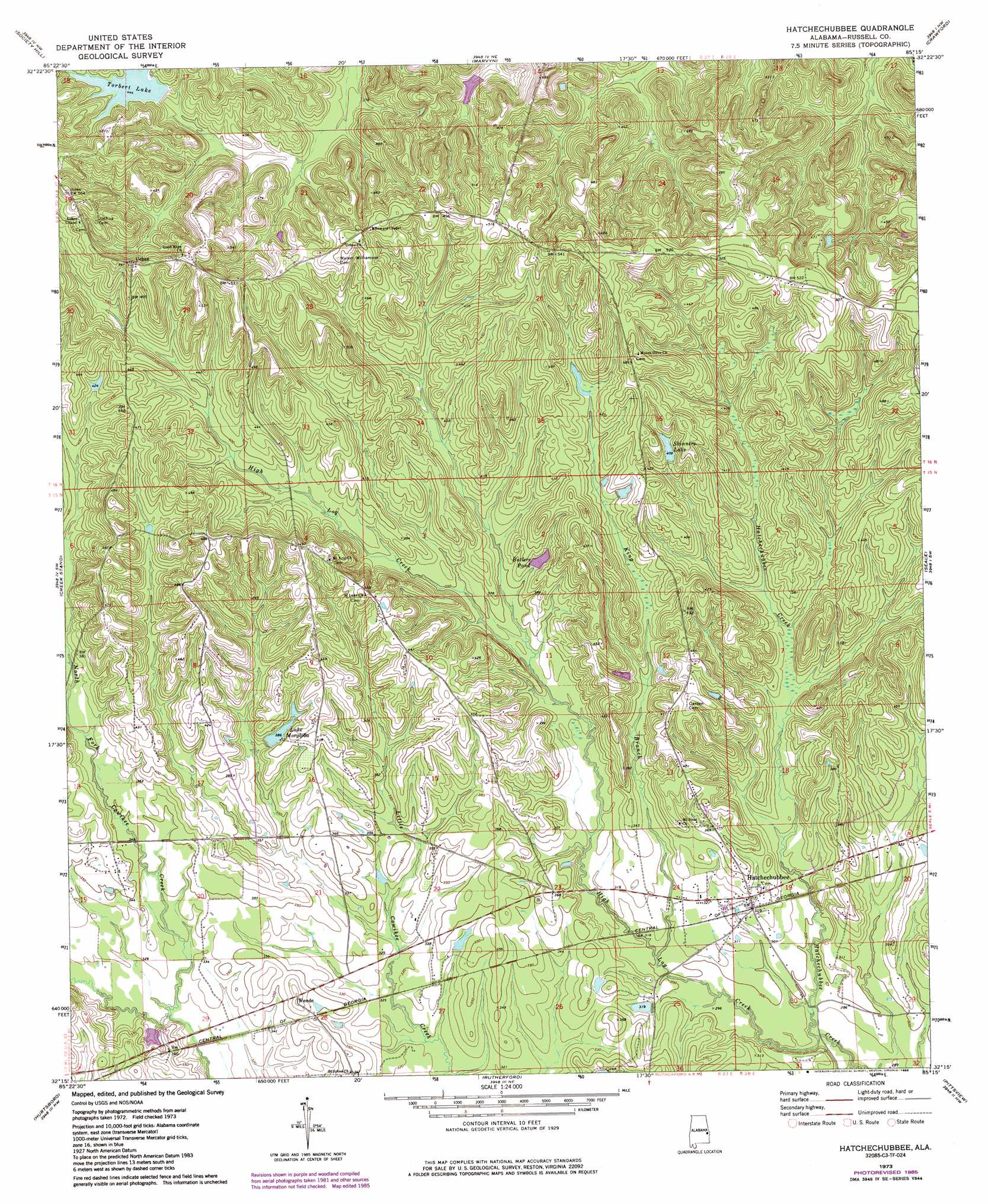
USGS Topo Quad 32085c3 - 1:24,000 scale
| Topo Map Name: | Hatchechubbee |
| USGS Topo Quad ID: | 32085c3 |
| Print Size: | ca. 21 1/4" wide x 27" high |
| Southeast Coordinates: | 32.25° N latitude / 85.25° W longitude |
| Map Center Coordinates: | 32.3125° N latitude / 85.3125° W longitude |
| U.S. State: | AL |
| Filename: | o32085c3.jpg |
| Download Map JPG Image: | Hatchechubbee topo map 1:24,000 scale |
| Map Type: | Topographic |
| Topo Series: | 7.5´ |
| Map Scale: | 1:24,000 |
| Source of Map Images: | United States Geological Survey (USGS) |
| Alternate Map Versions: |
Hatchechubbee AL 1973, updated 1975 Download PDF Buy paper map Hatchechubbee AL 1973, updated 1985 Download PDF Buy paper map Hatchechubbee AL 2011 Download PDF Buy paper map Hatchechubbee AL 2014 Download PDF Buy paper map |
1:24,000 Topo Quads surrounding Hatchechubbee
Loachapoka |
Auburn |
Parkers Crossroads |
Bleecker |
Smiths Station |
Little Texas |
Society Hill |
Marvyn |
Crawford |
Phenix City |
Warriorstand |
Creek Stand |
Hatchechubbee |
Seale |
Fort Mitchell |
Roba |
Hurtsboro |
Rutherford |
Pittsview |
Omaha |
Midway |
Comer |
Batesville |
Howe |
Twin Springs |
> Back to 32085a1 at 1:100,000 scale
> Back to 32084a1 at 1:250,000 scale
> Back to U.S. Topo Maps home
Hatchechubbee topo map: Gazetteer
Hatchechubbee: Dams
Margloba Dam elevation 122m 400′Torberts Lake Dam elevation 129m 423′
Hatchechubbee: Lakes
Smiths Pond (historical) elevation 137m 449′Hatchechubbee: Populated Places
Hatchechubbee elevation 97m 318′Uchee elevation 165m 541′
Wende elevation 107m 351′
Hatchechubbee: Post Offices
Hatchechubbee Post Office elevation 99m 324′Sandford Post Office (historical) elevation 134m 439′
Hatchechubbee: Reservoirs
Lake Morgloba elevation 119m 390′Skinners Lake elevation 124m 406′
Hatchechubbee: Streams
High Log Creek elevation 83m 272′King Branch elevation 89m 291′
Polecat Branch elevation 100m 328′
Porters Mill Creek elevation 106m 347′
Hatchechubbee: Swamps
Butlers Pond elevation 111m 364′Hatchechubbee digital topo map on disk
Buy this Hatchechubbee topo map showing relief, roads, GPS coordinates and other geographical features, as a high-resolution digital map file on DVD:
Gulf Coast (LA, MS, AL, FL) & Southwestern Georgia
Buy digital topo maps: Gulf Coast (LA, MS, AL, FL) & Southwestern Georgia
 & Southwestern Georgia map DVD")