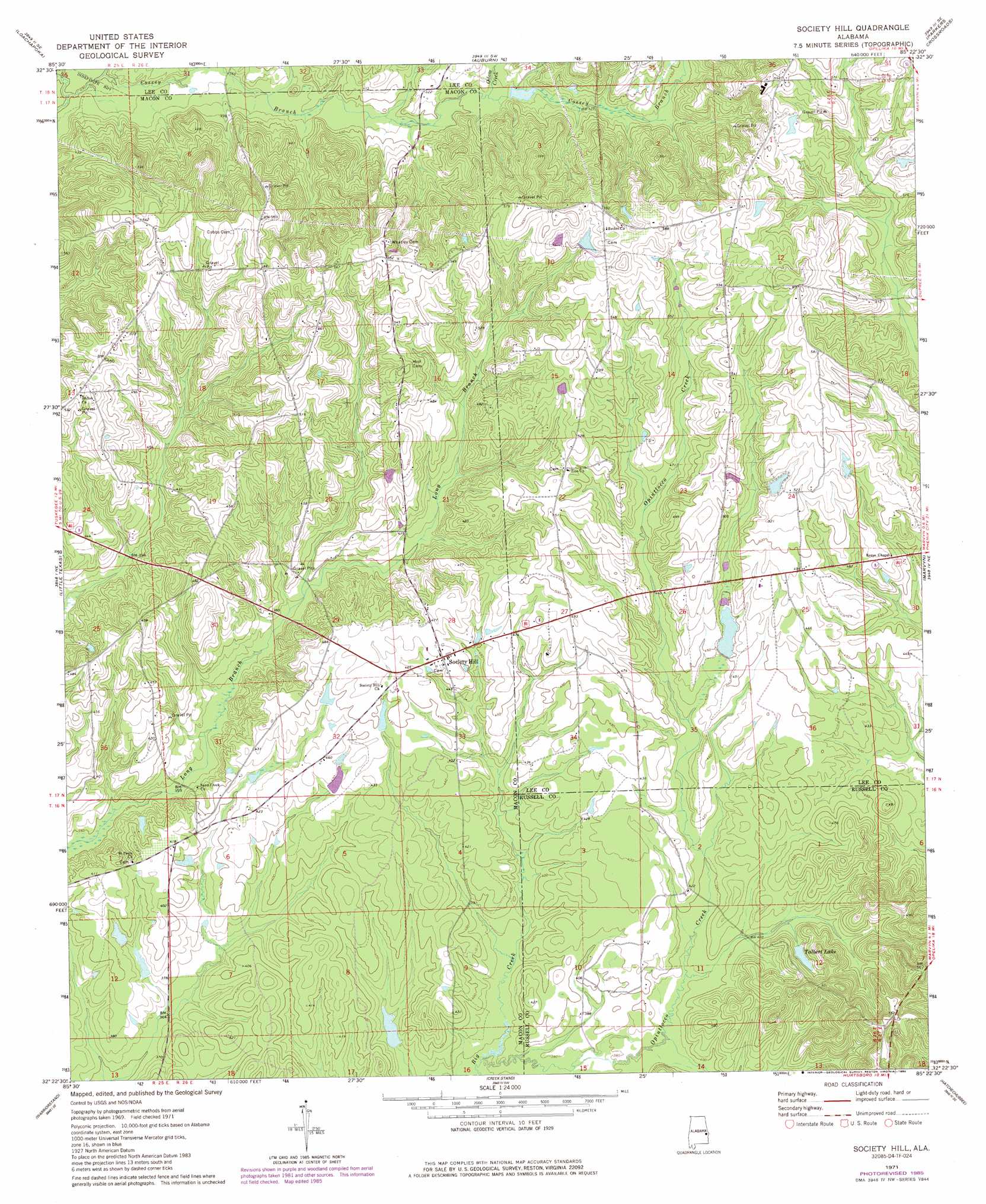
Society Hill Topo Map Alabama
To zoom in, hover over the map of Society Hill
USGS Topo Quad 32085d4 - 1:24,000 scale
| Topo Map Name: | Society Hill |
| USGS Topo Quad ID: | 32085d4 |
| Print Size: | ca. 21 1/4" wide x 27" high |
| Southeast Coordinates: | 32.375° N latitude / 85.375° W longitude |
| Map Center Coordinates: | 32.4375° N latitude / 85.4375° W longitude |
| U.S. State: | AL |
| Filename: | o32085d4.jpg |
| Download Map JPG Image: | Society Hill topo map 1:24,000 scale |
| Map Type: | Topographic |
| Topo Series: | 7.5´ |
| Map Scale: | 1:24,000 |
| Source of Map Images: | United States Geological Survey (USGS) |
| Alternate Map Versions: |
Society Hill AL 1971, updated 1973 Download PDF Buy paper map Society Hill AL 1971, updated 1986 Download PDF Buy paper map Society Hill AL 2011 Download PDF Buy paper map Society Hill AL 2014 Download PDF Buy paper map |
1:24,000 Topo Quads surrounding Society Hill
Thornton |
Waverly |
Opelika West |
Opelika East |
Beulah |
Notasulga |
Loachapoka |
Auburn |
Parkers Crossroads |
Bleecker |
Tuskegee |
Little Texas |
Society Hill |
Marvyn |
Crawford |
Davisville |
Warriorstand |
Creek Stand |
Hatchechubbee |
Seale |
Union Springs |
Roba |
Hurtsboro |
Rutherford |
Pittsview |
> Back to 32085a1 at 1:100,000 scale
> Back to 32084a1 at 1:250,000 scale
> Back to U.S. Topo Maps home
Society Hill topo map: Gazetteer
Society Hill: Dams
Ag Engineering Farm Pond elevation 134m 439′Huskeys Dam elevation 120m 393′
J P Groce Dam elevation 121m 396′
Jacobs Dam elevation 134m 439′
T U Kelly Number 1 Dam elevation 109m 357′
T U Kelly Number 2 Dam elevation 117m 383′
Talbert Dam elevation 141m 462′
Society Hill: Parks
Tsinia Wildlife Viewing Area elevation 152m 498′Society Hill: Populated Places
Society Hill elevation 143m 469′Society Hill: Reservoirs
Engineering Farm Pond elevation 134m 439′Groce Lake elevation 121m 396′
Huskeys Pond elevation 120m 393′
Kelly Pond Number Two elevation 117m 383′
Kellys Pond Number One elevation 109m 357′
Lake Jacobs elevation 134m 439′
Talbert Lake elevation 130m 426′
Society Hill: Streams
Ailey Branch elevation 128m 419′Bennett Branch elevation 128m 419′
Big Creek elevation 112m 367′
Odom Creek elevation 124m 406′
Strawberry Branch elevation 112m 367′
Society Hill digital topo map on disk
Buy this Society Hill topo map showing relief, roads, GPS coordinates and other geographical features, as a high-resolution digital map file on DVD:
Gulf Coast (LA, MS, AL, FL) & Southwestern Georgia
Buy digital topo maps: Gulf Coast (LA, MS, AL, FL) & Southwestern Georgia
 & Southwestern Georgia map DVD")