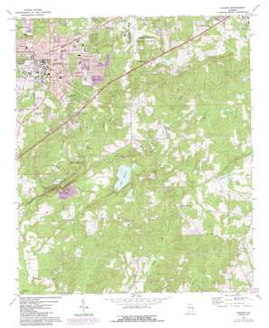
Auburn Topo Map Alabama
To zoom in, hover over the map of Auburn
USGS Topo Quad 32085e4 - 1:24,000 scale
| Topo Map Name: | Auburn |
| USGS Topo Quad ID: | 32085e4 |
| Print Size: | ca. 21 1/4" wide x 27" high |
| Southeast Coordinates: | 32.5° N latitude / 85.375° W longitude |
| Map Center Coordinates: | 32.5625° N latitude / 85.4375° W longitude |
| U.S. State: | AL |
| Filename: | o32085e4.jpg |
| Download Map JPG Image: | Auburn topo map 1:24,000 scale |
| Map Type: | Topographic |
| Topo Series: | 7.5´ |
| Map Scale: | 1:24,000 |
| Source of Map Images: | United States Geological Survey (USGS) |
| Alternate Map Versions: |
Auburn AL 1971, updated 1973 Download PDF Buy paper map Auburn AL 1971, updated 1984 Download PDF Buy paper map Auburn AL 2011 Download PDF Buy paper map Auburn AL 2014 Download PDF Buy paper map |
1:24,000 Topo Quads surrounding Auburn
> Back to 32085e1 at 1:100,000 scale
> Back to 32084a1 at 1:250,000 scale
> Back to U.S. Topo Maps home
Auburn topo map: Gazetteer
Auburn: Airports
Auburn-Opelika Robert G Pitts Airport elevation 233m 764′Auburn: Crossings
Interchange 57 elevation 204m 669′Auburn: Dams
Alnoname One Dam elevation 166m 544′Auburn Outing Club Dam elevation 149m 488′
Chewacla State Park Dam elevation 125m 410′
Country Club Dam elevation 223m 731′
Hamilton Dam elevation 210m 688′
Johnson Lake Dam elevation 166m 544′
Lake Ogletree Number One Dam elevation 145m 475′
M M Jones Dam elevation 178m 583′
Murphy Dam elevation 190m 623′
Ogletree Number Two Dam elevation 167m 547′
Prather Dam elevation 202m 662′
Roy Lazenby Dam elevation 136m 446′
Wilmore Dam elevation 155m 508′
Auburn: Lakes
Dukes Pond elevation 231m 757′Greg Lake elevation 149m 488′
Auburn: Parks
Auburn University Historic District elevation 213m 698′Bailey Park elevation 180m 590′
Chewacla State Park elevation 144m 472′
Donald E Davis Arboretum elevation 202m 662′
Duck Samford Park elevation 205m 672′
Fenton Little Park elevation 209m 685′
Hutsell Track elevation 192m 629′
Jordan-Hare Stadium elevation 195m 639′
Old Main and Church Street Historic District elevation 219m 718′
Auburn: Populated Places
Auburn elevation 215m 705′Bent Creek elevation 217m 711′
Cary Woods elevation 203m 666′
Cloverleaf elevation 186m 610′
Colonial Acres elevation 183m 600′
Country Hills elevation 182m 597′
Forestdale elevation 196m 643′
Glen Haven elevation 210m 688′
Hallway elevation 238m 780′
Indian Hills elevation 216m 708′
Mitchell Crossroads elevation 177m 580′
Oak Hollow elevation 162m 531′
Orr Estates elevation 236m 774′
Shelton Woods elevation 201m 659′
Tanglewood elevation 177m 580′
Terrace Acres elevation 201m 659′
Town and Country elevation 222m 728′
Twin Creeks elevation 158m 518′
Union Crossroads elevation 185m 606′
University Estates elevation 189m 620′
Whipporwill Estates elevation 166m 544′
Windsor Forest elevation 195m 639′
Windway elevation 171m 561′
Woodfield elevation 198m 649′
Woodland elevation 203m 666′
Woodland Hills elevation 208m 682′
Wright Crossroads elevation 156m 511′
Auburn: Post Offices
Auburn Post Office elevation 215m 705′Auburn: Reservoirs
Auburn City Lake elevation 145m 475′Auburn Outing Club Lake elevation 149m 488′
Barksdale Lake elevation 150m 492′
Chewacla State Park Lake elevation 125m 410′
Cress Outing Club Lake elevation 167m 547′
Davis Lake elevation 168m 551′
Hamilton Lake elevation 197m 646′
Johnson Lake elevation 166m 544′
Jones Lake elevation 183m 600′
Lake Ogletree elevation 140m 459′
Lake Whatley elevation 166m 544′
Lake Wilmore elevation 159m 521′
Lazenby Lake elevation 136m 446′
Mezicks Pond elevation 222m 728′
Neals Pond elevation 134m 439′
Orr Estates Lake elevation 209m 685′
Orr Estates Pond elevation 224m 734′
Prather Lake elevation 196m 643′
Sougahatchee Lake elevation 223m 731′
Stansons Lake elevation 217m 711′
Auburn: Streams
Moores Mill Creek elevation 125m 410′Nash Creek elevation 149m 488′
Parkerson Mill Creek elevation 113m 370′
Robinson Creek elevation 166m 544′
Auburn digital topo map on disk
Buy this Auburn topo map showing relief, roads, GPS coordinates and other geographical features, as a high-resolution digital map file on DVD:
Gulf Coast (LA, MS, AL, FL) & Southwestern Georgia
Buy digital topo maps: Gulf Coast (LA, MS, AL, FL) & Southwestern Georgia


