Notasulga Topo Map Alabama
To zoom in, hover over the map of Notasulga
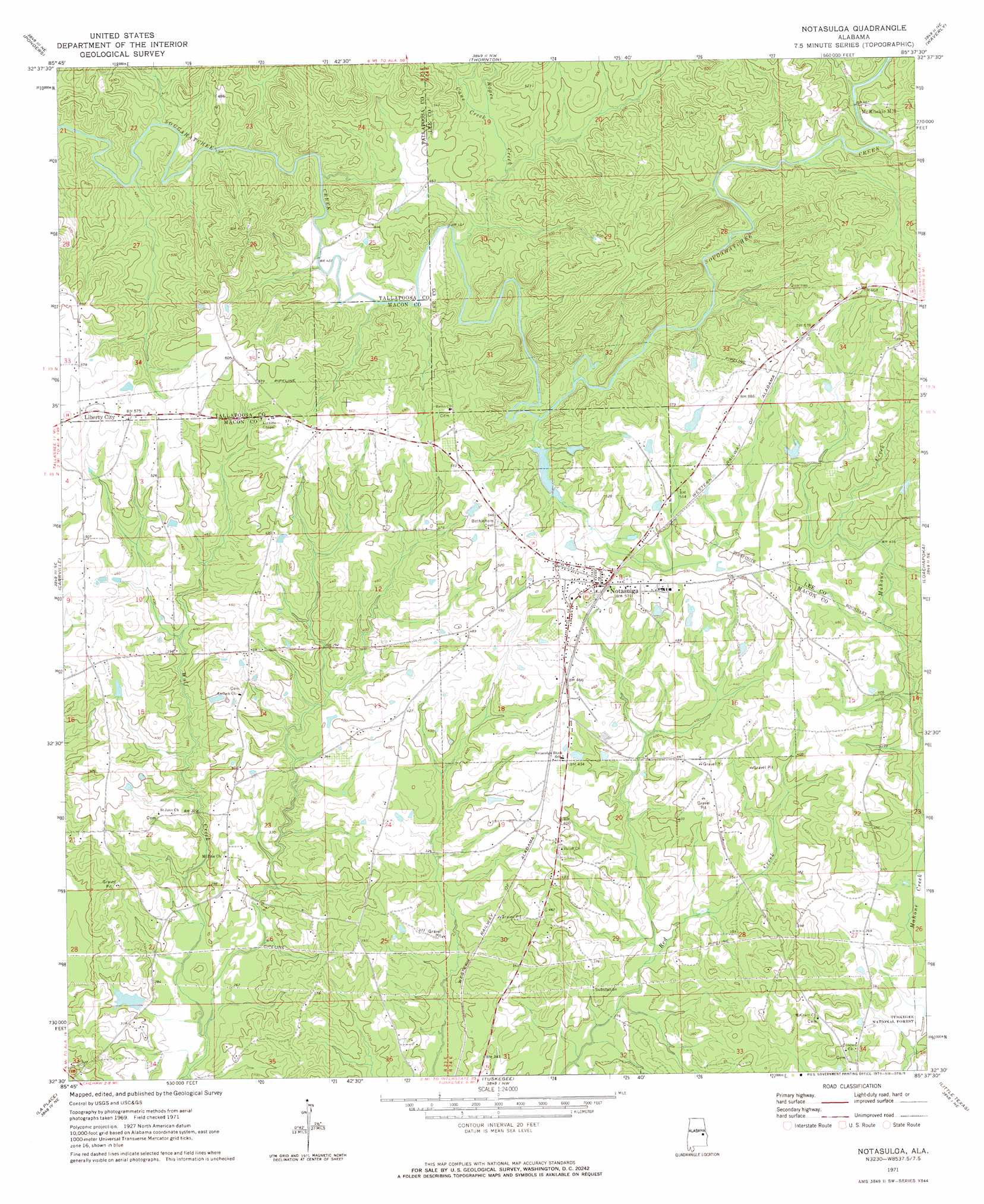
USGS Topo Quad 32085e6 - 1:24,000 scale
| Topo Map Name: | Notasulga |
| USGS Topo Quad ID: | 32085e6 |
| Print Size: | ca. 21 1/4" wide x 27" high |
| Southeast Coordinates: | 32.5° N latitude / 85.625° W longitude |
| Map Center Coordinates: | 32.5625° N latitude / 85.6875° W longitude |
| U.S. State: | AL |
| Filename: | o32085e6.jpg |
| Download Map JPG Image: | Notasulga topo map 1:24,000 scale |
| Map Type: | Topographic |
| Topo Series: | 7.5´ |
| Map Scale: | 1:24,000 |
| Source of Map Images: | United States Geological Survey (USGS) |
| Alternate Map Versions: |
Notasulga AL 1971, updated 1973 Download PDF Buy paper map Notasulga AL 1971, updated 1973 Download PDF Buy paper map Notasulga AL 2011 Download PDF Buy paper map Notasulga AL 2014 Download PDF Buy paper map |
| FStopo: | US Forest Service topo Notasulga is available: Download FStopo PDF Download FStopo TIF |
1:24,000 Topo Quads surrounding Notasulga
Our Town |
Dadeville |
Camp Hill |
Camp Hill Se |
Moorefield |
Red Hill |
Ponders |
Thornton |
Waverly |
Opelika West |
Tallassee |
Carrville |
Notasulga |
Loachapoka |
Auburn |
Shorter |
La Place |
Tuskegee |
Little Texas |
Society Hill |
Chesson |
Hardaway |
Davisville |
Warriorstand |
Creek Stand |
> Back to 32085e1 at 1:100,000 scale
> Back to 32084a1 at 1:250,000 scale
> Back to U.S. Topo Maps home
Notasulga topo map: Gazetteer
Notasulga: Bridges
Page Bridge elevation 144m 472′Notasulga: Dams
G E Kimbrough Dam elevation 160m 524′Notasulga City Lake Dam elevation 143m 469′
Williams Dam elevation 88m 288′
Notasulga: Populated Places
Liberty City elevation 174m 570′McRitchie Mill elevation 156m 511′
Notasulga elevation 156m 511′
Notasulga: Reservoirs
Kimbrough Lake elevation 160m 524′Notasulga City Lake elevation 143m 469′
Notasulga: Streams
Cane Creek elevation 137m 449′East Branch Wolfe Creek elevation 115m 377′
Oliver Creek elevation 71m 232′
Ropes Creek elevation 128m 419′
Town Creek elevation 137m 449′
West Branch Wolfe Creek elevation 115m 377′
Notasulga digital topo map on disk
Buy this Notasulga topo map showing relief, roads, GPS coordinates and other geographical features, as a high-resolution digital map file on DVD:
Gulf Coast (LA, MS, AL, FL) & Southwestern Georgia
Buy digital topo maps: Gulf Coast (LA, MS, AL, FL) & Southwestern Georgia
 & Southwestern Georgia map DVD")