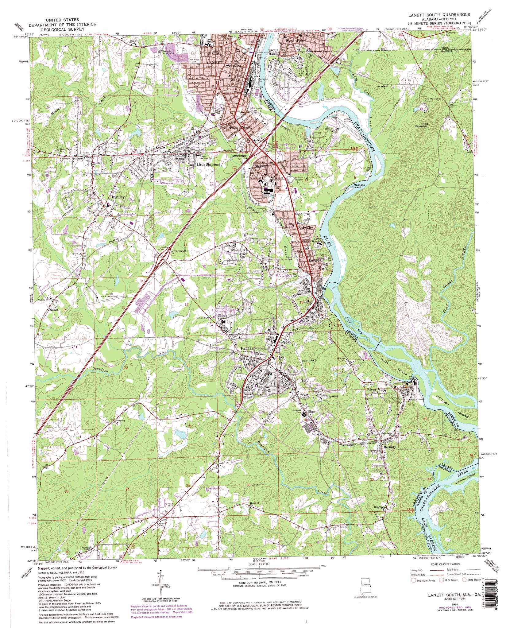
Lanett South Topo Map Alabama
To zoom in, hover over the map of Lanett South
USGS Topo Quad 32085g2 - 1:24,000 scale
| Topo Map Name: | Lanett South |
| USGS Topo Quad ID: | 32085g2 |
| Print Size: | ca. 21 1/4" wide x 27" high |
| Southeast Coordinates: | 32.75° N latitude / 85.125° W longitude |
| Map Center Coordinates: | 32.8125° N latitude / 85.1875° W longitude |
| U.S. States: | AL, GA |
| Filename: | o32085g2.jpg |
| Download Map JPG Image: | Lanett South topo map 1:24,000 scale |
| Map Type: | Topographic |
| Topo Series: | 7.5´ |
| Map Scale: | 1:24,000 |
| Source of Map Images: | United States Geological Survey (USGS) |
| Alternate Map Versions: |
Lanett South AL 1964, updated 1966 Download PDF Buy paper map Lanett South AL 1964, updated 1976 Download PDF Buy paper map Lanett South AL 1964, updated 1984 Download PDF Buy paper map Lanett South AL 1964, updated 1984 Download PDF Buy paper map Lanett South AL 2011 Download PDF Buy paper map Lanett South AL 2011 Download PDF Buy paper map Lanett South AL 2014 Download PDF Buy paper map |
1:24,000 Topo Quads surrounding Lanett South
Milltown |
Five Points |
Abbottsford |
La Grange |
Mountville |
Lafayette |
Fredonia |
Lanett North |
Cannonville |
Hilyer |
Moorefield |
Cusseta |
Lanett South |
Whitesville |
Pine Mountain Sw |
Opelika West |
Opelika East |
Beulah |
Bartletts Ferry Dam |
Mulberry Grove |
Auburn |
Parkers Crossroads |
Bleecker |
Smiths Station |
Fortson |
> Back to 32085e1 at 1:100,000 scale
> Back to 32084a1 at 1:250,000 scale
> Back to U.S. Topo Maps home
Lanett South topo map: Gazetteer
Lanett South: Airports
George H Lanier Memorial Hospital Airport elevation 193m 633′Lanett Municipal Airport elevation 188m 616′
Valley Airport elevation 173m 567′
Lanett South: Bends
Great Bend elevation 179m 587′Lanett South: Crossings
Cave Springs Crossing (historical) elevation 159m 521′Houston Ferry (historical) elevation 159m 521′
Interchange 77 elevation 207m 679′
Interchange 79 elevation 188m 616′
Magnolia Ferry (historical) elevation 169m 554′
Lanett South: Dams
Beal Juniors Lake Dam elevation 180m 590′Beal Lake Dam elevation 182m 597′
Phillips Dam elevation 198m 649′
Riverside Number 1 Dam elevation 199m 652′
Riverside Number 2 Dam elevation 199m 652′
Taunton Dam elevation 183m 600′
Lanett South: Guts
Crow Hop elevation 163m 534′Lanett South: Islands
Hills Island elevation 190m 623′Johnson Island elevation 188m 616′
Magnolia Island elevation 166m 544′
Lanett South: Parks
Jennings Field elevation 187m 613′Tater Miller Field elevation 177m 580′
West Side Park elevation 183m 600′
Lanett South: Populated Places
Eady City elevation 182m 597′Fairfax elevation 206m 675′
Glass elevation 206m 675′
Huguley elevation 214m 702′
Lanett elevation 180m 590′
Langdale elevation 182m 597′
Little Shawmut elevation 195m 639′
McGinty elevation 207m 679′
Nelson elevation 197m 646′
Osanippa elevation 202m 662′
Plant City elevation 190m 623′
River View elevation 192m 629′
Shawmut elevation 184m 603′
Valley elevation 173m 567′
Lanett South: Post Offices
Fairfax Post Office elevation 202m 662′Lanett Post Office elevation 182m 597′
Langdale Post Office elevation 176m 577′
River View Post Office elevation 193m 633′
Shawmut Post Office elevation 185m 606′
Lanett South: Reservoirs
Beal Juniors Lake elevation 180m 590′Beal Lake elevation 182m 597′
Philips Lake elevation 198m 649′
Riverside Number One Lake elevation 199m 652′
Riverside Number Two Lake elevation 199m 652′
Taunton Lake elevation 183m 600′
Lanett South: Streams
Flat Shoal Creek elevation 159m 521′Little Osanippa Creek elevation 176m 577′
Long Cane Creek elevation 166m 544′
Moores Creek elevation 164m 538′
Lanett South: Summits
The Mountain elevation 274m 898′Lanett South digital topo map on disk
Buy this Lanett South topo map showing relief, roads, GPS coordinates and other geographical features, as a high-resolution digital map file on DVD:
Gulf Coast (LA, MS, AL, FL) & Southwestern Georgia
Buy digital topo maps: Gulf Coast (LA, MS, AL, FL) & Southwestern Georgia
 & Southwestern Georgia map DVD")