Cannonville Topo Map Georgia
To zoom in, hover over the map of Cannonville
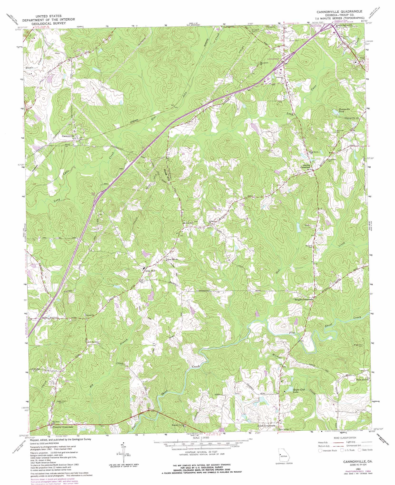
USGS Topo Quad 32085h1 - 1:24,000 scale
| Topo Map Name: | Cannonville |
| USGS Topo Quad ID: | 32085h1 |
| Print Size: | ca. 21 1/4" wide x 27" high |
| Southeast Coordinates: | 32.875° N latitude / 85° W longitude |
| Map Center Coordinates: | 32.9375° N latitude / 85.0625° W longitude |
| U.S. State: | GA |
| Filename: | o32085h1.jpg |
| Download Map JPG Image: | Cannonville topo map 1:24,000 scale |
| Map Type: | Topographic |
| Topo Series: | 7.5´ |
| Map Scale: | 1:24,000 |
| Source of Map Images: | United States Geological Survey (USGS) |
| Alternate Map Versions: |
Cannonville GA 1964, updated 1965 Download PDF Buy paper map Cannonville GA 1964, updated 1974 Download PDF Buy paper map Cannonville GA 1964, updated 1984 Download PDF Buy paper map Cannonville GA 2011 Download PDF Buy paper map Cannonville GA 2014 Download PDF Buy paper map |
1:24,000 Topo Quads surrounding Cannonville
Roanoke East |
Glenn |
Hillcrest |
Hogansville |
Grantville |
Five Points |
Abbottsford |
La Grange |
Mountville |
Odessadale |
Fredonia |
Lanett North |
Cannonville |
Hilyer |
Durand |
Cusseta |
Lanett South |
Whitesville |
Pine Mountain Sw |
Pine Mountain |
Opelika East |
Beulah |
Bartletts Ferry Dam |
Mulberry Grove |
Cataula |
> Back to 32085e1 at 1:100,000 scale
> Back to 32084a1 at 1:250,000 scale
> Back to U.S. Topo Maps home
Cannonville topo map: Gazetteer
Cannonville: Bridges
State Bridge elevation 188m 616′Cannonville: Crossings
Interchange 2 elevation 213m 698′Interchange 3 elevation 216m 708′
Cannonville: Dams
Dickerson Dam elevation 213m 698′Eagle Club Dam elevation 211m 692′
Hammetts Dam elevation 215m 705′
Murphy Lake Dam elevation 195m 639′
Webb Dam elevation 188m 616′
Zachery Dam elevation 220m 721′
Cannonville: Populated Places
Bartley Road Estates elevation 226m 741′Baughs Crossroads elevation 223m 731′
Cannonville elevation 205m 672′
Colonial Heights elevation 239m 784′
Cottons Crossroads elevation 221m 725′
Federal Hills elevation 218m 715′
Gray Hill elevation 237m 777′
Hogg Mountain elevation 228m 748′
Maplecreek Hills elevation 219m 718′
Old Chimney elevation 213m 698′
Parkway Estates elevation 217m 711′
Pioneer Village elevation 221m 725′
Plantation Manor elevation 231m 757′
Raby Woods elevation 234m 767′
Smiths Crossroad elevation 236m 774′
Smoke Rise elevation 198m 649′
South Pine Ranchettes elevation 237m 777′
West Wood elevation 223m 731′
Wood Valley elevation 217m 711′
Cannonville: Reservoirs
Dickerson Lake elevation 213m 698′Eagle Club Lake elevation 211m 692′
Hammetts Pond elevation 215m 705′
Murphy Lake elevation 195m 639′
Webb Lake elevation 188m 616′
Zachery Lake elevation 220m 721′
Cannonville: Streams
Blue John Creek elevation 189m 620′Mud Creek elevation 185m 606′
Panther Creek elevation 201m 659′
Wildcat Creek elevation 183m 600′
Cannonville: Summits
Hogg Mountain elevation 264m 866′Cannonville digital topo map on disk
Buy this Cannonville topo map showing relief, roads, GPS coordinates and other geographical features, as a high-resolution digital map file on DVD:
Gulf Coast (LA, MS, AL, FL) & Southwestern Georgia
Buy digital topo maps: Gulf Coast (LA, MS, AL, FL) & Southwestern Georgia
 & Southwestern Georgia map DVD")