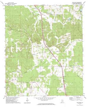
Pine Level Topo Map Alabama
To zoom in, hover over the map of Pine Level
USGS Topo Quad 32086a1 - 1:24,000 scale
| Topo Map Name: | Pine Level |
| USGS Topo Quad ID: | 32086a1 |
| Print Size: | ca. 21 1/4" wide x 27" high |
| Southeast Coordinates: | 32° N latitude / 86° W longitude |
| Map Center Coordinates: | 32.0625° N latitude / 86.0625° W longitude |
| U.S. State: | AL |
| Filename: | o32086a1.jpg |
| Download Map JPG Image: | Pine Level topo map 1:24,000 scale |
| Map Type: | Topographic |
| Topo Series: | 7.5´ |
| Map Scale: | 1:24,000 |
| Source of Map Images: | United States Geological Survey (USGS) |
| Alternate Map Versions: |
Pine Level AL 1971, updated 1974 Download PDF Buy paper map Pine Level AL 1971, updated 1974 Download PDF Buy paper map Pine Level AL 2011 Download PDF Buy paper map Pine Level AL 2014 Download PDF Buy paper map |
1:24,000 Topo Quads surrounding Pine Level
> Back to 32086a1 at 1:100,000 scale
> Back to 32086a1 at 1:250,000 scale
> Back to U.S. Topo Maps home
Pine Level topo map: Gazetteer
Pine Level: Dams
C E Sellers Number 3 Dam elevation 130m 426′C E Sellers Number 4 Dam elevation 119m 390′
I D McClurkin Number 1 Dam elevation 154m 505′
Jack Wool Dam elevation 115m 377′
Pine Level: Populated Places
Currys elevation 145m 475′Macedonia elevation 147m 482′
Pine Level elevation 149m 488′
Pine Level: Post Offices
Pine Level Post Office elevation 150m 492′Pine Level: Reservoirs
I D McClurkin Number One Lake elevation 154m 505′Lake Ben elevation 115m 377′
Sellers Lake Number Four elevation 119m 390′
Sellers Lake Number Three elevation 130m 426′
Sellers Ponds elevation 126m 413′
Pine Level digital topo map on disk
Buy this Pine Level topo map showing relief, roads, GPS coordinates and other geographical features, as a high-resolution digital map file on DVD:
Gulf Coast (LA, MS, AL, FL) & Southwestern Georgia
Buy digital topo maps: Gulf Coast (LA, MS, AL, FL) & Southwestern Georgia


