Calhoun Topo Map Alabama
To zoom in, hover over the map of Calhoun
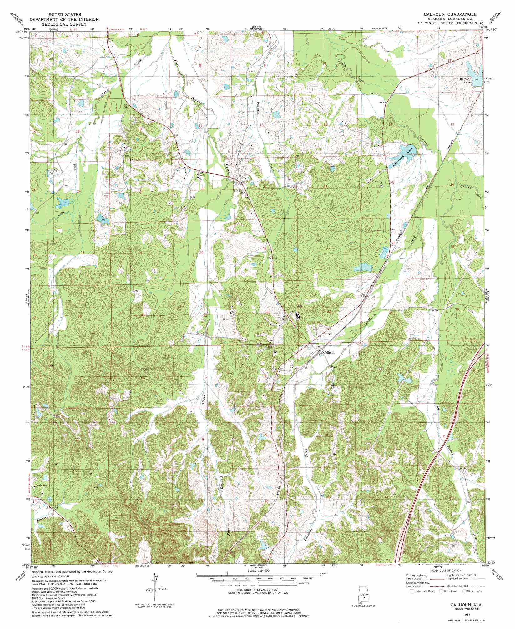
USGS Topo Quad 32086a5 - 1:24,000 scale
| Topo Map Name: | Calhoun |
| USGS Topo Quad ID: | 32086a5 |
| Print Size: | ca. 21 1/4" wide x 27" high |
| Southeast Coordinates: | 32° N latitude / 86.5° W longitude |
| Map Center Coordinates: | 32.0625° N latitude / 86.5625° W longitude |
| U.S. State: | AL |
| Filename: | o32086a5.jpg |
| Download Map JPG Image: | Calhoun topo map 1:24,000 scale |
| Map Type: | Topographic |
| Topo Series: | 7.5´ |
| Map Scale: | 1:24,000 |
| Source of Map Images: | United States Geological Survey (USGS) |
| Alternate Map Versions: |
Calhoun AL 1981, updated 1981 Download PDF Buy paper map Calhoun AL 2011 Download PDF Buy paper map Calhoun AL 2014 Download PDF Buy paper map |
1:24,000 Topo Quads surrounding Calhoun
Benton |
White Hall |
Lowndesboro |
Cantelous |
Montgomery South |
Collirene |
Gordonsville |
Hayneville |
Letohatchee |
Snowdoun |
Braggs |
Mount Willing |
Calhoun |
Sandy Ridge |
Sellers |
Ridgeville |
Fort Dale |
Fort Deposit |
Danielsville |
Lapine |
Forest Home |
Greenville West |
Greenville East |
Honoraville |
Fullers Crossroads |
> Back to 32086a1 at 1:100,000 scale
> Back to 32086a1 at 1:250,000 scale
> Back to U.S. Topo Maps home
Calhoun topo map: Gazetteer
Calhoun: Dams
Ben Spear Dam elevation 67m 219′Hammond Number One Dam elevation 64m 209′
Hammond Number Two Dam elevation 74m 242′
Calhoun: Populated Places
Calhoun elevation 84m 275′Calhoun: Reservoirs
Collins Lake elevation 75m 246′Hammond Lake elevation 70m 229′
Hammonds Lake elevation 77m 252′
Hartleys Pond elevation 95m 311′
Lanes Pond elevation 76m 249′
Midfield Lake elevation 76m 249′
Moore Pond elevation 98m 321′
Olson Pond elevation 104m 341′
Spear Lake elevation 67m 219′
Calhoun: Streams
Ballards Creek elevation 67m 219′Calhoun: Summits
Gilmer Hills elevation 142m 465′Skidl Hill elevation 142m 465′
Calhoun digital topo map on disk
Buy this Calhoun topo map showing relief, roads, GPS coordinates and other geographical features, as a high-resolution digital map file on DVD:
Gulf Coast (LA, MS, AL, FL) & Southwestern Georgia
Buy digital topo maps: Gulf Coast (LA, MS, AL, FL) & Southwestern Georgia
 & Southwestern Georgia map DVD")