Teasleys Mill Topo Map Alabama
To zoom in, hover over the map of Teasleys Mill
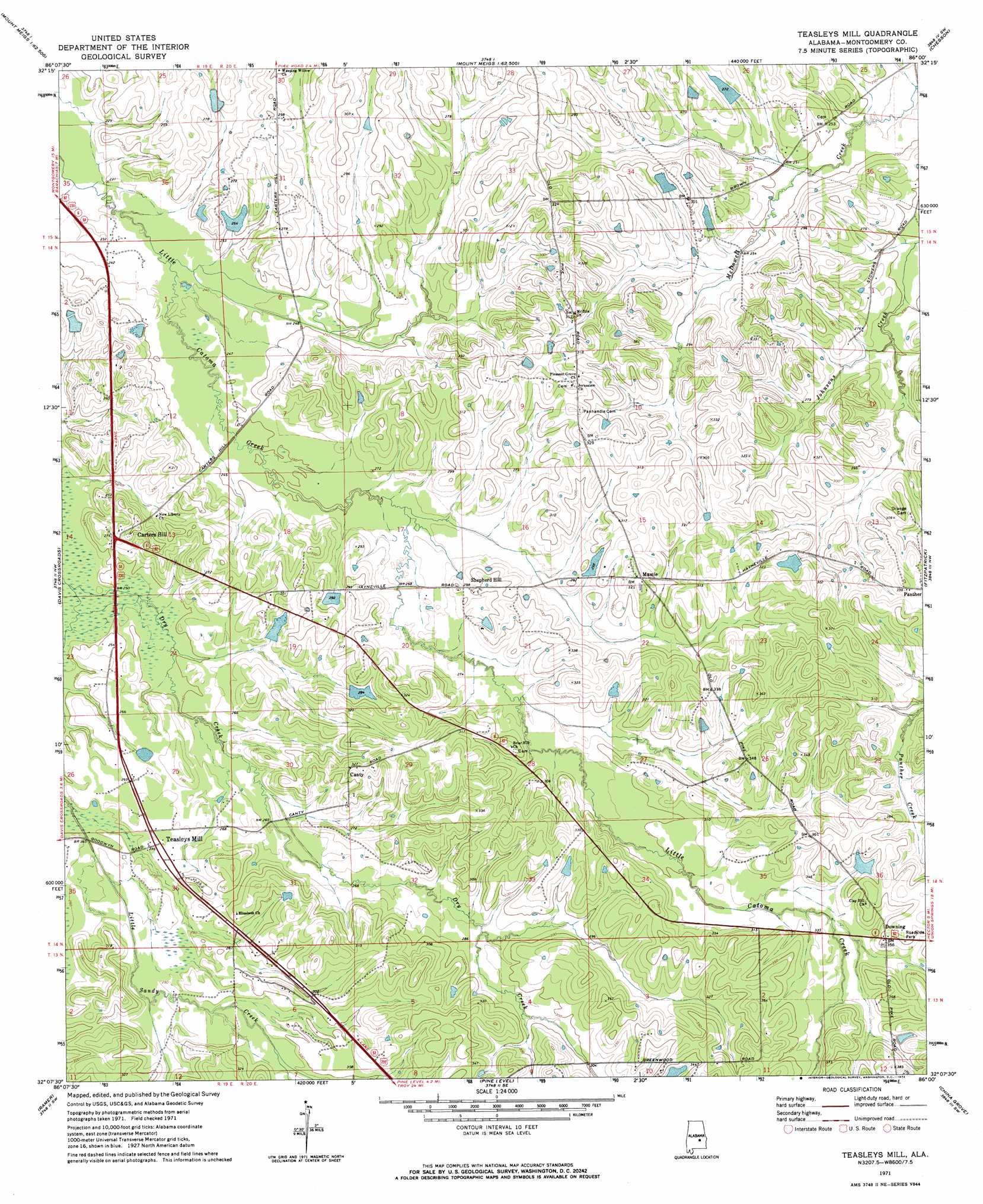
USGS Topo Quad 32086b1 - 1:24,000 scale
| Topo Map Name: | Teasleys Mill |
| USGS Topo Quad ID: | 32086b1 |
| Print Size: | ca. 21 1/4" wide x 27" high |
| Southeast Coordinates: | 32.125° N latitude / 86° W longitude |
| Map Center Coordinates: | 32.1875° N latitude / 86.0625° W longitude |
| U.S. State: | AL |
| Filename: | o32086b1.jpg |
| Download Map JPG Image: | Teasleys Mill topo map 1:24,000 scale |
| Map Type: | Topographic |
| Topo Series: | 7.5´ |
| Map Scale: | 1:24,000 |
| Source of Map Images: | United States Geological Survey (USGS) |
| Alternate Map Versions: |
Teasleys Mill AL 1971, updated 1974 Download PDF Buy paper map Teasleys Mill AL 1971, updated 1974 Download PDF Buy paper map Teasleys Mill AL 2011 Download PDF Buy paper map Teasleys Mill AL 2014 Download PDF Buy paper map |
1:24,000 Topo Quads surrounding Teasleys Mill
Montgomery North |
Willow Springs |
Brassell |
Shorter |
La Place |
Montgomery South |
Barachias |
Mount Meigs |
Chesson |
Hardaway |
Snowdoun |
Davis Crossroads |
Teasleys Mill |
Fitzpatrick |
Thompson |
Sellers |
Ramer |
Pine Level |
China Grove |
Almeria |
Lapine |
Grady |
Ansley |
Needmore |
Saco |
> Back to 32086a1 at 1:100,000 scale
> Back to 32086a1 at 1:250,000 scale
> Back to U.S. Topo Maps home
Teasleys Mill topo map: Gazetteer
Teasleys Mill: Dams
Allison Dam elevation 86m 282′Brooks Number 2 Dam elevation 90m 295′
Guy Pugh Dam elevation 105m 344′
Kirksey Dam elevation 76m 249′
Lee Merriweather Dam elevation 81m 265′
Morris Dees Number 2 Dam elevation 79m 259′
T S Turnipseed Dam elevation 100m 328′
W C Gray Dam elevation 83m 272′
W J Sorrell Dam elevation 89m 291′
W R Turnipseed Dam elevation 90m 295′
Teasleys Mill: Populated Places
Canty elevation 98m 321′Carters Hill elevation 85m 278′
Downing elevation 107m 351′
Mamie elevation 96m 314′
Shepherd Hill elevation 89m 291′
Teasleys Mill elevation 83m 272′
Teasleys Mill: Reservoirs
Allison Lake elevation 86m 282′Brooks Lake Number Two elevation 90m 295′
Grays Lake elevation 83m 272′
Kirksey Lake elevation 76m 249′
Lake Pugh elevation 105m 344′
Merriweather Lake elevation 81m 265′
Morris Dees Lake Number Two elevation 79m 259′
Sorrell Lake elevation 89m 291′
T S Turnipseed Lake elevation 100m 328′
W R Turnipseed Lake elevation 90m 295′
Teasleys Mill digital topo map on disk
Buy this Teasleys Mill topo map showing relief, roads, GPS coordinates and other geographical features, as a high-resolution digital map file on DVD:
Gulf Coast (LA, MS, AL, FL) & Southwestern Georgia
Buy digital topo maps: Gulf Coast (LA, MS, AL, FL) & Southwestern Georgia
 & Southwestern Georgia map DVD")