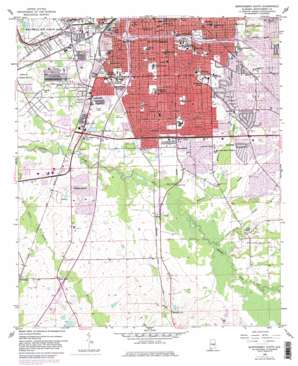
Montgomery South Topo Map Alabama
To zoom in, hover over the map of Montgomery South
USGS Topo Quad 32086c3 - 1:24,000 scale
| Topo Map Name: | Montgomery South |
| USGS Topo Quad ID: | 32086c3 |
| Print Size: | ca. 21 1/4" wide x 27" high |
| Southeast Coordinates: | 32.25° N latitude / 86.25° W longitude |
| Map Center Coordinates: | 32.3125° N latitude / 86.3125° W longitude |
| U.S. State: | AL |
| Filename: | o32086c3.jpg |
| Download Map JPG Image: | Montgomery South topo map 1:24,000 scale |
| Map Type: | Topographic |
| Topo Series: | 7.5´ |
| Map Scale: | 1:24,000 |
| Source of Map Images: | United States Geological Survey (USGS) |
| Alternate Map Versions: |
Montgomery South AL 1958, updated 1959 Download PDF Buy paper map Montgomery South AL 1958, updated 1968 Download PDF Buy paper map Montgomery South AL 1958, updated 1973 Download PDF Buy paper map Montgomery South AL 1958, updated 1982 Download PDF Buy paper map Montgomery South AL 1958, updated 1982 Download PDF Buy paper map Montgomery South AL 1975, updated 1977 Download PDF Buy paper map Montgomery South AL 2011 Download PDF Buy paper map Montgomery South AL 2014 Download PDF Buy paper map |
1:24,000 Topo Quads surrounding Montgomery South
> Back to 32086a1 at 1:100,000 scale
> Back to 32086a1 at 1:250,000 scale
> Back to U.S. Topo Maps home
Montgomery South topo map: Gazetteer
Montgomery South: Airports
Baptist Medical Center Airport elevation 63m 206′Montgomery South: Bridges
Norman Bridge elevation 50m 164′Pete Peterson Bridge elevation 47m 154′
Montgomery South: Canals
Genetta Ditch elevation 55m 180′Montgomery South: Crossings
Interchange 1 elevation 75m 246′Interchange 164 elevation 62m 203′
Interchange 168 elevation 52m 170′
Interchange 169 elevation 56m 183′
Interchange 170 elevation 59m 193′
Interchange 171 elevation 81m 265′
Interchange 2 elevation 83m 272′
Interchange 3 elevation 78m 255′
Lees Ferry (historical) elevation 46m 150′
Montgomery South: Dams
Davis Number 4 Dam elevation 74m 242′Davis Number 5 Dam elevation 74m 242′
Farm Bureau Dam elevation 64m 209′
Fisher Dam elevation 76m 249′
Frank Davis Dam elevation 70m 229′
Montgomery South: Islands
Walker Island (historical) elevation 61m 200′Montgomery South: Parks
Bellingrath Park elevation 65m 213′Bruce Park elevation 87m 285′
Crump Park elevation 59m 193′
Diffly Park elevation 55m 180′
Hayneville Road Park elevation 51m 167′
Hornet Stadium elevation 72m 236′
Oak Park elevation 86m 282′
Old Selma Road Park elevation 52m 170′
Smiley Young Park elevation 52m 170′
Taylor Field elevation 74m 242′
Washington Park elevation 63m 206′
Western Hills Park elevation 65m 213′
Woodcrest Park elevation 52m 170′
Montgomery South: Populated Places
Arlington elevation 59m 193′Bellemeade elevation 64m 209′
Brentwood elevation 69m 226′
Brickdale Estates elevation 52m 170′
Carver Park elevation 56m 183′
Cleveland Meadows elevation 55m 180′
Cloverdale elevation 76m 249′
Cloverland elevation 66m 216′
Clubview Estates elevation 71m 232′
Cross Creek elevation 60m 196′
Druid Hills elevation 64m 209′
Edgemont Heights elevation 62m 203′
Elsmeade elevation 68m 223′
English Village elevation 58m 190′
Gay Meadows elevation 70m 229′
Gibbs Village elevation 52m 170′
Gladlane Estates elevation 66m 216′
Governors Estates elevation 62m 203′
Greater Washington Park elevation 51m 167′
Grove Hill elevation 76m 249′
Highland Village elevation 51m 167′
Hillwood elevation 84m 275′
Hillwood West elevation 84m 275′
Hope Hull elevation 63m 206′
Lagos del Sol elevation 65m 213′
Lakeview Heights elevation 86m 282′
Lynndale elevation 67m 219′
Lynwood Terrace elevation 58m 190′
Maxwell Heights elevation 51m 167′
Mayfair elevation 85m 278′
McGehee Estates elevation 72m 236′
McGehees elevation 72m 236′
Memorial Heights elevation 61m 200′
Mobile Heights elevation 65m 213′
Montgomery elevation 73m 239′
Normandale elevation 70m 229′
Oak Park elevation 79m 259′
Perry Hills elevation 82m 269′
Powelldale elevation 64m 209′
Prairie View Estates elevation 50m 164′
Ridgecrest elevation 62m 203′
Ridgefield elevation 82m 269′
Rosemond Estates elevation 71m 232′
Seth Johnson Estates elevation 64m 209′
Southern Meadows elevation 61m 200′
Southlawn elevation 58m 190′
Southlawn East elevation 62m 203′
Southmont elevation 57m 187′
Spring Park elevation 62m 203′
Spring Valley elevation 64m 209′
Steiner elevation 79m 259′
Sunshine Acres elevation 56m 183′
Valley Whispers elevation 68m 223′
Vaughan Meadows elevation 80m 262′
Village West elevation 61m 200′
Washington Park elevation 70m 229′
West End elevation 52m 170′
Western Hills elevation 61m 200′
Westgate elevation 62m 203′
Westview Gardens elevation 50m 164′
Wildwood elevation 71m 232′
Wiley elevation 56m 183′
Windwood elevation 58m 190′
Woodcrest Estates elevation 53m 173′
Woodley East Estates elevation 68m 223′
Woodley Park elevation 65m 213′
Young Forte Village elevation 53m 173′
Montgomery South: Post Offices
Hope Hull Post Office elevation 70m 229′Montgomery Post Office elevation 62m 203′
Montgomery South: Reservoirs
Farm Bureau Lake elevation 64m 209′Fisher Lake elevation 76m 249′
Frank Davis Lake elevation 70m 229′
Hillake elevation 53m 173′
Twin Lakes elevation 73m 239′
Montgomery South: Streams
Baldwin Slough elevation 48m 157′Ramer Creek elevation 55m 180′
Whites Slough elevation 51m 167′
Montgomery South digital topo map on disk
Buy this Montgomery South topo map showing relief, roads, GPS coordinates and other geographical features, as a high-resolution digital map file on DVD:
Gulf Coast (LA, MS, AL, FL) & Southwestern Georgia
Buy digital topo maps: Gulf Coast (LA, MS, AL, FL) & Southwestern Georgia


