Cantelous Topo Map Alabama
To zoom in, hover over the map of Cantelous
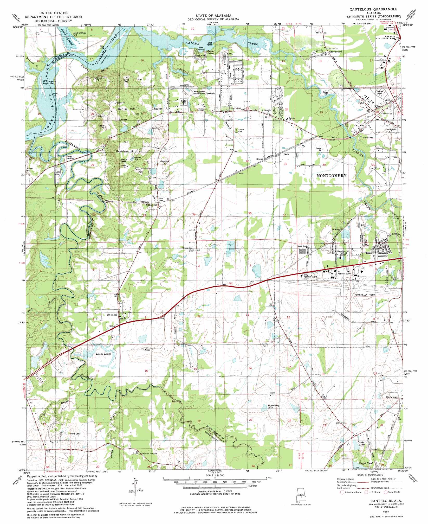
USGS Topo Quad 32086c4 - 1:24,000 scale
| Topo Map Name: | Cantelous |
| USGS Topo Quad ID: | 32086c4 |
| Print Size: | ca. 21 1/4" wide x 27" high |
| Southeast Coordinates: | 32.25° N latitude / 86.375° W longitude |
| Map Center Coordinates: | 32.3125° N latitude / 86.4375° W longitude |
| U.S. State: | AL |
| Filename: | o32086c4.jpg |
| Download Map JPG Image: | Cantelous topo map 1:24,000 scale |
| Map Type: | Topographic |
| Topo Series: | 7.5´ |
| Map Scale: | 1:24,000 |
| Source of Map Images: | United States Geological Survey (USGS) |
| Alternate Map Versions: |
Montgomery SW AL 1975, updated 1977 Download PDF Buy paper map Cantelous AL 1981, updated 1982 Download PDF Buy paper map Cantelous AL 1981, updated 1984 Download PDF Buy paper map Cantelous AL 2011 Download PDF Buy paper map Cantelous AL 2014 Download PDF Buy paper map |
1:24,000 Topo Quads surrounding Cantelous
Vida |
Old Kingston |
Deatsville |
Elmore |
Wetumpka |
Autaugaville |
Forester |
Prattville |
Montgomery North |
Willow Springs |
White Hall |
Lowndesboro |
Cantelous |
Montgomery South |
Barachias |
Gordonsville |
Hayneville |
Letohatchee |
Snowdoun |
Davis Crossroads |
Mount Willing |
Calhoun |
Sandy Ridge |
Sellers |
Ramer |
> Back to 32086a1 at 1:100,000 scale
> Back to 32086a1 at 1:250,000 scale
> Back to U.S. Topo Maps home
Cantelous topo map: Gazetteer
Cantelous: Airports
Dannelly Field elevation 61m 200′Cantelous: Bars
Graves Bar elevation 37m 121′Lower Catoma Bar elevation 40m 131′
Manack Bar elevation 37m 121′
O'Possum Bight Bar elevation 41m 134′
Cantelous: Bends
Durant Bend elevation 44m 144′Cantelous: Dams
Baggett Dam elevation 64m 209′Bowling Dam elevation 62m 203′
C D Long Lake Dam elevation 44m 144′
C H Warner Dam elevation 57m 187′
D W Rutland Dam elevation 87m 285′
Elgin Dam elevation 63m 206′
Flowers Dam elevation 52m 170′
Cantelous: Islands
Manacks Island (historical) elevation 37m 121′Cantelous: Parks
Selbrook Park elevation 46m 150′Twin Gates Park elevation 53m 173′
Cantelous: Populated Places
Antioch elevation 52m 170′Brewer Estates elevation 63m 206′
Cantelous elevation 63m 206′
Catoma elevation 64m 209′
Cedar Point elevation 46m 150′
Country Estates elevation 49m 160′
Dannley Pines elevation 61m 200′
Fairview elevation 52m 170′
Grovewood elevation 47m 154′
Lee Farms elevation 48m 157′
Mount Sinai elevation 58m 190′
Selbrook elevation 48m 157′
Stones elevation 51m 167′
Twin Gates Estates elevation 53m 173′
Cantelous: Reservoirs
Baggett Lake elevation 64m 209′C D Long Lake elevation 44m 144′
Elgin Lake elevation 63m 206′
Flowers Lake elevation 52m 170′
Lake Bowling elevation 62m 203′
Lake Linda elevation 62m 203′
Lucky Lakes elevation 47m 154′
Rutland Lake elevation 87m 285′
Sugarberry Lake elevation 62m 203′
Warner Lake elevation 57m 187′
Cantelous: Streams
Antioch Branch elevation 40m 131′Caney Branch elevation 46m 150′
Catoma Creek elevation 37m 121′
Dry Creek elevation 43m 141′
Noland Creek elevation 37m 121′
Pintlala Creek elevation 37m 121′
Rock Creek elevation 41m 134′
Steep Creek elevation 45m 147′
Cantelous: Summits
Cantelous Hill elevation 104m 341′Gunter Hill elevation 94m 308′
Cantelous digital topo map on disk
Buy this Cantelous topo map showing relief, roads, GPS coordinates and other geographical features, as a high-resolution digital map file on DVD:
Gulf Coast (LA, MS, AL, FL) & Southwestern Georgia
Buy digital topo maps: Gulf Coast (LA, MS, AL, FL) & Southwestern Georgia
 & Southwestern Georgia map DVD")