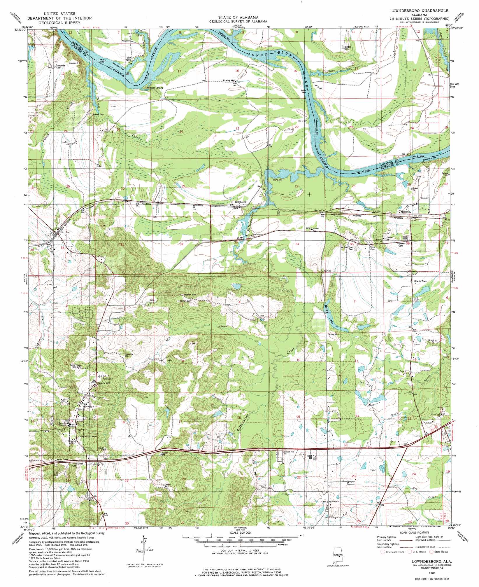
Lowndesboro Topo Map Alabama
To zoom in, hover over the map of Lowndesboro
USGS Topo Quad 32086c5 - 1:24,000 scale
| Topo Map Name: | Lowndesboro |
| USGS Topo Quad ID: | 32086c5 |
| Print Size: | ca. 21 1/4" wide x 27" high |
| Southeast Coordinates: | 32.25° N latitude / 86.5° W longitude |
| Map Center Coordinates: | 32.3125° N latitude / 86.5625° W longitude |
| U.S. State: | AL |
| Filename: | o32086c5.jpg |
| Download Map JPG Image: | Lowndesboro topo map 1:24,000 scale |
| Map Type: | Topographic |
| Topo Series: | 7.5´ |
| Map Scale: | 1:24,000 |
| Source of Map Images: | United States Geological Survey (USGS) |
| Alternate Map Versions: |
Autaugaville SE AL 1975, updated 1977 Download PDF Buy paper map Lowndesboro AL 1981, updated 1981 Download PDF Buy paper map Lowndesboro AL 1981, updated 1981 Download PDF Buy paper map Lowndesboro AL 2011 Download PDF Buy paper map Lowndesboro AL 2014 Download PDF Buy paper map |
1:24,000 Topo Quads surrounding Lowndesboro
Milton |
Vida |
Old Kingston |
Deatsville |
Elmore |
Durant Bend |
Autaugaville |
Forester |
Prattville |
Montgomery North |
Benton |
White Hall |
Lowndesboro |
Cantelous |
Montgomery South |
Collirene |
Gordonsville |
Hayneville |
Letohatchee |
Snowdoun |
Braggs |
Mount Willing |
Calhoun |
Sandy Ridge |
Sellers |
> Back to 32086a1 at 1:100,000 scale
> Back to 32086a1 at 1:250,000 scale
> Back to U.S. Topo Maps home
Lowndesboro topo map: Gazetteer
Lowndesboro: Bars
Huffman Bar elevation 38m 124′Newport Bar elevation 38m 124′
Tallawassee Bar elevation 38m 124′
Lowndesboro: Dams
Mcqueens Dam elevation 62m 203′Nichols Dam elevation 67m 219′
Reese Dam elevation 51m 167′
York Number 2 Dam elevation 71m 232′
Lowndesboro: Lakes
Berry Lake elevation 53m 173′Lowndesboro: Populated Places
Burkville elevation 46m 150′Lowndesboro elevation 123m 403′
Manack elevation 61m 200′
Robinsons elevation 47m 154′
Saint Clair elevation 63m 206′
Lowndesboro: Post Offices
Burkville Post Office elevation 46m 150′Lowndesboro Post Office elevation 126m 413′
Saint Clair Post Office elevation 64m 209′
Lowndesboro: Reservoirs
Dickens Pond elevation 92m 301′McQueens Pond elevation 61m 200′
Nichols Lake elevation 67m 219′
York Lake elevation 71m 232′
Lowndesboro: Streams
Bear Creek elevation 38m 124′Billdee Creek elevation 38m 124′
Dry Creek elevation 52m 170′
Powell Creek elevation 38m 124′
Rocky Branch elevation 38m 124′
Tallawassee Creek elevation 38m 124′
Tensaw Creek elevation 39m 127′
Lowndesboro digital topo map on disk
Buy this Lowndesboro topo map showing relief, roads, GPS coordinates and other geographical features, as a high-resolution digital map file on DVD:
Gulf Coast (LA, MS, AL, FL) & Southwestern Georgia
Buy digital topo maps: Gulf Coast (LA, MS, AL, FL) & Southwestern Georgia
 & Southwestern Georgia map DVD")