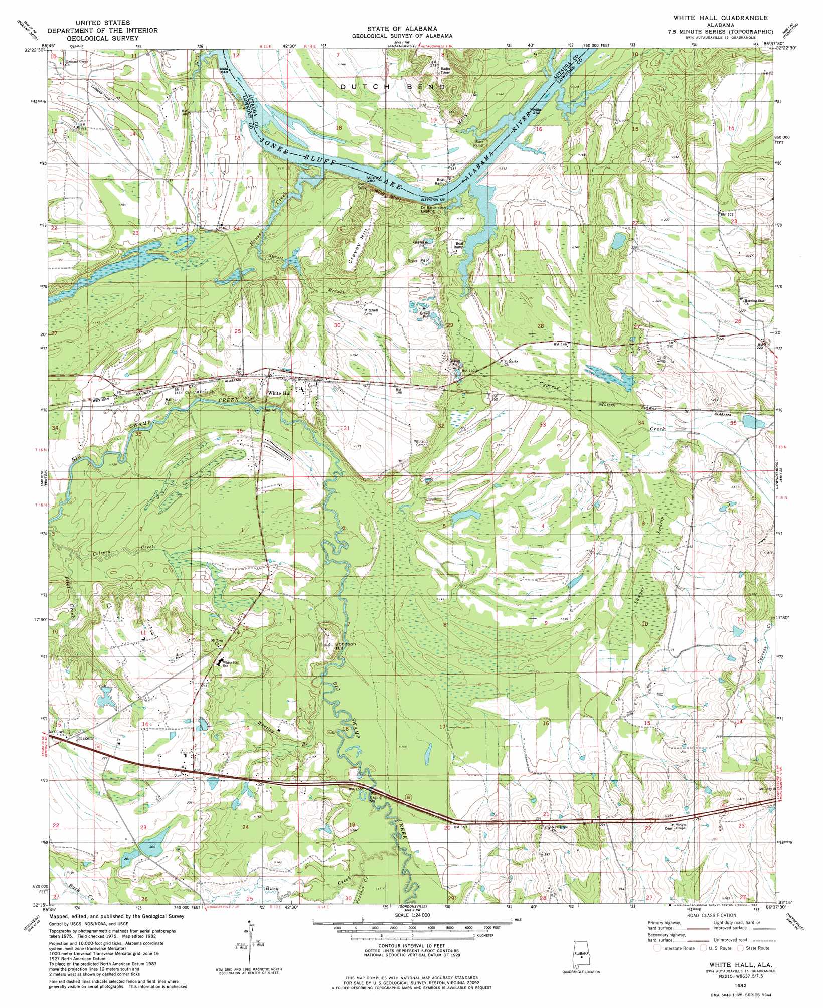
White Hall Topo Map Alabama
To zoom in, hover over the map of White Hall
USGS Topo Quad 32086c6 - 1:24,000 scale
| Topo Map Name: | White Hall |
| USGS Topo Quad ID: | 32086c6 |
| Print Size: | ca. 21 1/4" wide x 27" high |
| Southeast Coordinates: | 32.25° N latitude / 86.625° W longitude |
| Map Center Coordinates: | 32.3125° N latitude / 86.6875° W longitude |
| U.S. State: | AL |
| Filename: | o32086c6.jpg |
| Download Map JPG Image: | White Hall topo map 1:24,000 scale |
| Map Type: | Topographic |
| Topo Series: | 7.5´ |
| Map Scale: | 1:24,000 |
| Source of Map Images: | United States Geological Survey (USGS) |
| Alternate Map Versions: |
Autaugaville SW AL 1975, updated 1977 Download PDF Buy paper map White Hall AL 1982, updated 1982 Download PDF Buy paper map White Hall AL 2011 Download PDF Buy paper map White Hall AL 2014 Download PDF Buy paper map |
1:24,000 Topo Quads surrounding White Hall
Jones |
Milton |
Vida |
Old Kingston |
Deatsville |
Burnsville |
Durant Bend |
Autaugaville |
Forester |
Prattville |
Sardis |
Benton |
White Hall |
Lowndesboro |
Cantelous |
Pleasant Hill |
Collirene |
Gordonsville |
Hayneville |
Letohatchee |
Minter |
Braggs |
Mount Willing |
Calhoun |
Sandy Ridge |
> Back to 32086a1 at 1:100,000 scale
> Back to 32086a1 at 1:250,000 scale
> Back to U.S. Topo Maps home
White Hall topo map: Gazetteer
White Hall: Bars
Holy Ground Bar elevation 38m 124′White Hall: Cliffs
Blue Bluff elevation 61m 200′White Hall: Crossings
Powells Ferry (historical) elevation 38m 124′White Hall: Dams
B C Rhyne Lake Dam elevation 63m 206′C H Rhyne Dam elevation 59m 193′
Cooper Branch Narrows Lake Dam elevation 43m 141′
White Hall: Populated Places
Trickem elevation 65m 213′White Hall elevation 56m 183′
White Hall: Reservoirs
B C Rhyne Lake elevation 63m 206′Hoffman Rhyne Lake elevation 59m 193′
Milligans Pond elevation 53m 173′
The Narrows Lake elevation 43m 141′
White Hall: Streams
Buck Creek elevation 43m 141′Cypress Creek elevation 38m 124′
House Creek elevation 38m 124′
Molly Branch elevation 38m 124′
Panther Creek elevation 43m 141′
Pilot Creek elevation 34m 111′
Spratt Branch elevation 38m 124′
Whatley Branch elevation 43m 141′
White Hall: Summits
Cravey Hill elevation 81m 265′Johnson Hill elevation 65m 213′
White Hall: Swamps
Sawyer Swamp elevation 43m 141′White Hall digital topo map on disk
Buy this White Hall topo map showing relief, roads, GPS coordinates and other geographical features, as a high-resolution digital map file on DVD:
Gulf Coast (LA, MS, AL, FL) & Southwestern Georgia
Buy digital topo maps: Gulf Coast (LA, MS, AL, FL) & Southwestern Georgia
 & Southwestern Georgia map DVD")