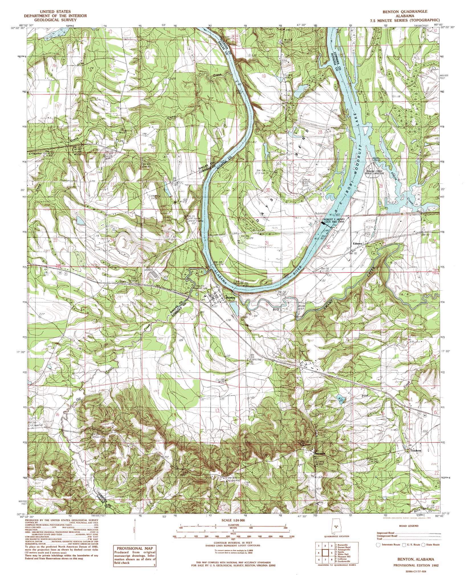
Benton Topo Map Alabama
To zoom in, hover over the map of Benton
USGS Topo Quad 32086c7 - 1:24,000 scale
| Topo Map Name: | Benton |
| USGS Topo Quad ID: | 32086c7 |
| Print Size: | ca. 21 1/4" wide x 27" high |
| Southeast Coordinates: | 32.25° N latitude / 86.75° W longitude |
| Map Center Coordinates: | 32.3125° N latitude / 86.8125° W longitude |
| U.S. State: | AL |
| Filename: | o32086c7.jpg |
| Download Map JPG Image: | Benton topo map 1:24,000 scale |
| Map Type: | Topographic |
| Topo Series: | 7.5´ |
| Map Scale: | 1:24,000 |
| Source of Map Images: | United States Geological Survey (USGS) |
| Alternate Map Versions: |
Benton SE AL 1975 Download PDF Buy paper map Benton AL 1982, updated 1983 Download PDF Buy paper map Benton AL 2011 Download PDF Buy paper map Benton AL 2014 Download PDF Buy paper map |
1:24,000 Topo Quads surrounding Benton
Summerfield |
Jones |
Milton |
Vida |
Old Kingston |
Selma |
Burnsville |
Durant Bend |
Autaugaville |
Forester |
Blackwell Bend |
Sardis |
Benton |
White Hall |
Lowndesboro |
Elm Bluff |
Pleasant Hill |
Collirene |
Gordonsville |
Hayneville |
Carlowville |
Minter |
Braggs |
Mount Willing |
Calhoun |
> Back to 32086a1 at 1:100,000 scale
> Back to 32086a1 at 1:250,000 scale
> Back to U.S. Topo Maps home
Benton topo map: Gazetteer
Benton: Bars
Bar Below Benton elevation 27m 88′Benton: Bends
Days Bend elevation 46m 150′Benton: Dams
B C Rhyne Dam elevation 36m 118′M A Richard Dam elevation 49m 160′
Robert F Henry Lock and Dam elevation 24m 78′
Upchurch Lake Dam elevation 34m 111′
Benton: Parks
Prairie Creek Public Land Use elevation 40m 131′Benton: Populated Places
Benton elevation 43m 141′Edsons elevation 41m 134′
Petronia elevation 129m 423′
Benton: Post Offices
Benton Post Office elevation 43m 141′Benton: Reservoirs
B C Rhyne Lake elevation 36m 118′R E 'Bob' Woodruff Reservoir elevation 24m 78′
Richard Lake elevation 49m 160′
Benton: Streams
Big Swamp Creek elevation 24m 78′Camp Creek elevation 28m 91′
Old Town Creek elevation 24m 78′
Prairie Creek elevation 38m 124′
Valley Creek elevation 31m 101′
Benton digital topo map on disk
Buy this Benton topo map showing relief, roads, GPS coordinates and other geographical features, as a high-resolution digital map file on DVD:
Gulf Coast (LA, MS, AL, FL) & Southwestern Georgia
Buy digital topo maps: Gulf Coast (LA, MS, AL, FL) & Southwestern Georgia
 & Southwestern Georgia map DVD")